The winter of 2009-2010 will go down as one of the best ever (if you like winter, that is). The biggest reason for that is February 2010 and its cascade of significant winter storms that placed the month as one of the snowiest of all time. The February 5-6, 2010 snowstorm event was one of the capping events of the month and winter as a whole.
The first event started in the morning on February 5th. Forecasts in the days leading up to this event were mixed. Models were showing a lot of precipitation, but also a strong push of upper-level warm air into Ohio. How far north this warm layer reached was the point of contention. In most years, the WTOD, or the “Warm Tongue of Death” as some Ohio weather enthusiasts like to refer to it, is a constant threat each and every winter. When a storm is moving north or northeast south of the state, they tend to pull warm air north, and the Appalachian Mountains act like a funnel directing this warm air straight into Ohio. During winter events, it presents itself as a layer of warm air above the surface, often turning snow to ice, sleet or just plain rain, even if the surface itself is relatively cold. It’s a constant source of frustration for winter weather lovers. It was this phenomenon that was predicted to strike again and the dividing line, as it so often is, was predicted to be along I-70/I-71. North of there, mostly or all snow was predicted, while south was more mix, ice and rain. The I-70 corridor, including Columbus, was to be the northern extent of this mixing, limiting snowfall accumulations. Still, even with the mix predicted, a solid 4″-6″ was predicted, which is a decent event by itself and typically the largest snow event of any given winter.
Precipitation began as snow across southern counties by dawn and spread north, reaching the Columbus area between 9AM and 9:30AM. It started out as flurries, but the flakes were already fairly large. Within 15 minutes, the flurries had turned to very heavy, wet snow. Flakes were as large as quarters at times and stayed large, accumulating quickly despite the above freezing temperatures. Visibility quickly dropped to a half mile or less at times, and traffic quickly snarled with accidents as plows could not keep up with the pace of the inch-per-hour snowfall rates. Between 4PM and 5PM, there was a respite as snowfall lightened and there was a mix of sleet and ice pellets, but all snow resumed once heavier precipitation moved in, concluding the only and very short period of mixing I-70 had. Snow continued through the night of the 5th and into the 6th, finally ending before noon.
Snowfall totals were impressive, especially along and north of I-70, where little mixing took place, but also in pockets to the southeast of Columbus, like Lancaster. For Columbus, the 9.9″ that fell was good enough to be a top 15 largest snowstorm for the city. It would not, however, be the largest snowfall of the month.
Some snow totals across Ohio from February 5-6, 2010
Greenville: 14.8″
Lancaster: 13.0″
Akron: 12.1″
Bellefontaine: 12.0″
Urbana: 12.0″
Westerville: 11.4″
Dayton: 11.1″
Springfield: 11.0″
Columbus: 9.9″
Youngstown: 8.4″
Delaware: 8.0″
Cleveland: 5.9″
Cincinnati: 4.5″
Circleville: 3.0″
Toledo: 3.0″
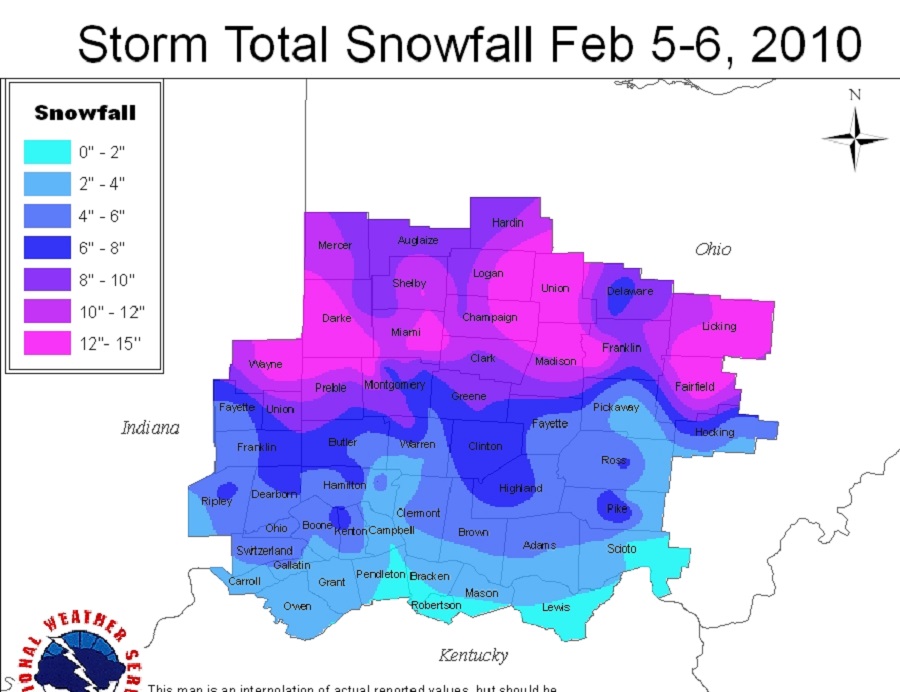
Snow totals for the NWS Wilmington area.
This event was the only the beginning of what would be a trio of consecutive snowstorms that would strike the area over the course of 11 days, including the February 9-10, 2010 Snowstorm, which occurred just a few days later.
The Wilmington National Weather Service, meanwhile, is a great source if you want to know the current weather in the area.