

This page details extreme temperature events around Columbus since the 19th Century. Events are listed in chronological order starting with the most recent, and divided by event type.
**Last Updated: 11/10/2025- Added to 1990-1999.
Extreme Cold
2020-2029
2010-2019
2000-2009
1990-1999
April 9th-15th, 1997
April 1997 was about 4-5 degrees colder than normal across the state, with the peak coming mid-month. Temperatures bottomed out in the teens and low 20s on some of the mornings during this period, with highs failing to make it out of the 30s across Central Ohio on the 9th. The cold damaged some plants and trees that were beginning to bloom. Columbus temperatures were below normal on all but 4 days during the month, and lows hit freezing or below on 10 days.
January, 1997
Although the winter of 1996-97 went down as warmer than average, January did have two brief, but memorable cold spells mid-month. The first occurred on the 11th-13th when temperatures across much of the state failed to make it out of the single-digits for highs, with lows below zero. Columbus temperatures stayed between -1 and 13 degrees over the course of the period. A second cold wave on the 17th-18th produced similar conditions. Wind chills during both periods were between -25 and -40 degrees. Pipes froze and ruptured, and some people were treated for or succumbed to hypothermia across the state, though none occurred in Central Ohio.
January, 1994
January 1994 was described as a “classic” when it came to winter weather. Siginficant snowstorms and record cold made January the highlight of the 1993-1994 winter season. The coldest period of the month occuring between the 14th and 22nd and featured the coldest temperatures Columbus has ever experienced. The month as a whole is detailed on the Ohio’s Greatest Arctic Outbreak page.
Here are some articles from the month.
January 16, 1994: City shivers through coldest day since 1989
January 19, 1994: City shivers under brutal cold
January 20, 1994: It was the coldest day ever Part 1
January 20, 1994: It was the coldest day ever Part 2
1980-1989
December, 1985
The fall of 1985 had been very wet, but not particularly cold. That changed in December when temperatures fell below normal on the 2nd and stayed there most of the rest of the month. Similar to December 2000 or 2010, December 1985 had no extreme cold- its lowest temperature was 0 on the 26th- but rather was just consistently well below normal. The average temperature of 26 degrees is the 13th lowest on record and 7.5 degrees below the average. The cold weather pattern that brought with it several light snowfalls kept an inch or two of snow cover on the ground for most of the month. The persistent cold did not last into January, 1986, which was almost 4 degrees above normal.
December, 1983
A bit colder than normal fall and first half of the month turned significantly colder after the 16th of December. Successive cold fronts on the 14th-15th and then again on the 22nd brought gradually colder weather, culminating in the coldest Christmas Eve and Christmas Day in history. The stronger front on the 22nd turned temperatures from the low 40s into the single digits. Christmas Eve had a high of just 4 with a low of -12, but Christmas Day was even colder, with a high of only 1 degree above zero and a low of -12, with wind chills reportedly being around 50 below. The cold weather brought broken pipes, stalled cars and even some power outages as some transformers broke down. No Christmas before or since has been as cold. The month of December overall ended up nearly 9 degrees below normal.
1970-1979
1960-1969
1950-1959
January, 1950
January 1950 was a very warm month in what was one of the warmest winters on record up to that time. The weather was so consistently warm that nature itself seemed confused. The Climatological Report for the month stated the following:
It was warm enough to cause the appearance of small new leaves and a few blossoms on certain shrubs northward as far as Columbus. Tulips and other plants sent up shoots several inches above the ground. Crocus bloomed in some places.
Columbus warmth peaked with a high of 74 degrees on the 25th, the warmest temperature ever recorded for January and indeed the warmest ever recorded for the entire December-January-February period as a whole up to that point. Today, the high still stands as the warmest for the date. The record for the warmest high for the entire winter was not matched again until February 11, 1999, but wasn’t broken until February 26, 2000 when the high hit 75. The current winter record is 78, reached on February 24, 2017.
1940-1949
January, 1940
For winter weather, the decade of the 1940s was not very noteworthy. On average, its winters produced the least snowfall and most were well above average in temperatures. The decade did not begin that way, however. January 1940 was historically cold, and with an average temperature of just 17.8 degrees- almost 12 degrees below normal- and remains the 3rd coldest January ever recorded. Temperatures were in the teens on New Year’s Day and remained below freezing for most of the month. Lows fell below 0 on 4 days, with the cold peak occurring on the 19th with a high of 2 and a low of -11. Snowfall was normal, and the cold kept measurable snow on the ground on all but 3 days.
1870-1879
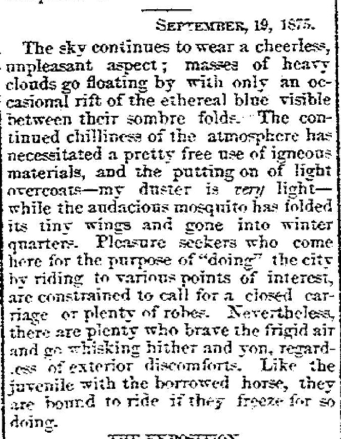
September, 1875
An unusually cold period occurred mid-late September of 1875. Although temperature records are not available for the time, it seems- based on the below except from the Columbus Dispatch- that the cold was indeed unusual for the season.
Extreme Heat
1930-1939
1936
Summer 1936
The 5th warmest summer on record for Ohio and the 2nd warmest for Columbus, Summer 1936 followed a very cold winter and spring that saw measurable snow through April 21st. The first heat arrived the 2nd week of May, with a high of 94 on the 9th, and May-June were generally above normal. However, it would be July, 1936 that truly put the summer in the record books, with the greatest heat wave of all time. Between July 7th-18th, the average high was 99.7 degrees, and reached over 100 degrees for 7 consecutive days, the longest such stretch in history. The 106 degrees on July 14th tied for the hottest temperature ever recorded in Columbus. Temperatures reached over 100 again on July 27th and August 19th. The summer’s 9 days over 100 degrees remains the most of any summer since 1878.
Summer 1934
Officially the hottest summer ever in Ohio and Columbus to the present day, it was able to accomplish this feat despite August 1934 being slightly below normal, an indication of the extreme heat in June and July. Temperatures reached 90 or higher on 39 days between June-August, the 5th most on record, but temperatures often far surpassed that mark. Three separate heat waves scorched Ohio, each one more intense than the last. The first was from May 31st-June 4th, when the high reached 96 degrees on the 1st. The second occurred between June 24th and July 5th, and included 2 rare June 100-degree days, peaking at 101 on the 28th. The third heat wave occurred from July 19th-26th. With an average high of 100.5 during the heat wave, and temperatures reaching a record 106, it was the worst heat in Columbus history up to that time. It’s only been matched or beaten once, just 2 years later.
The average temperature in Ohio during Summer 1934 was 77.5 degrees, half a degree higher than any other summer before or since.
For more historic weather events, visit the
Significant Events Archive