
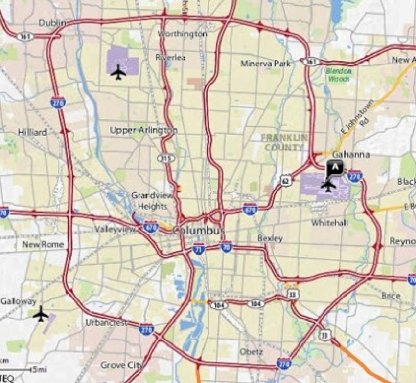
The road and highway system history for Columbus goes all the way back to the very founding of the city. Chronicled here is an expanding list of dates and events that shaped the current system.
**Last Updated: 6/18/2024- Added new dates to 1960-1969.
1797-1809
One of the first known roads built in Franklinton is Sandusky Street, which runs north-south across the fledgling community. It gets its name because it leads of out Franklinton on a collection of trails towards the town of Sandusky on Lake Erie.
After Worthington is founded in 1803, a connecting road is built between the two villages. The road runs south from Worthington near the present-day course of High Street, turns west near present-day Brevoort Road, follows the Olentangy River before crossing near present-day Dodridge Street. It then follows the west bank of the Olentangy until crossing the river at what was once the Sandusky Street Bridge.
1810-1819
1816
Lucas Sullivant constructs a wooden bridge at Broad Street across the Scioto River, the first bridge to cross the river. Crossings prior to bridge construction were made by ferry.
1820-1829
1823
The first iteration of Park Street is laid out from what was the north end of Front Street to around modern Goodale. The road is created to allow better access to the old North Graveyard.
1824
The first Broad Street bridge over the Scioto River rots to the point of collapse. A new bridge of similar design is quickly rebuilt.
1830-1839
1830
The first iteration of what would become Park Street is vacated on petition by Lincoln Goodale when North Graveyard expands enough to allow direct access from High Street.
1832
The second Broad Street bridge is destroyed in a flood. A third bridge begins construction almost immediately.
1833
The National Road is completed through Columbus.
1834
The third Broad Street bridge over the Scioto, a wooden covered bridge, is completed by the US government.
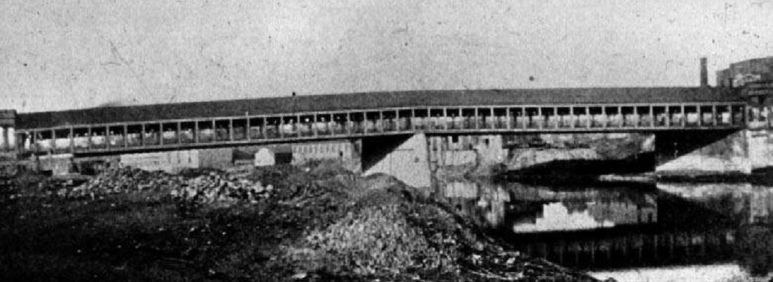
The Broad Street covered bridge, likely in the 1870s.
1840-1849
1850-1859
1857
Columbus posts the names of its streets for the first time at a cost of $528.87.
1860-1869
1863
The first bridge across the Olentangy River, at King Avenue, is completed. It is a steel truss design.
1870-1879
1873
Parts of Broad Street Downtown are surfaced with gravel and broken stone to combat the almost impassible mud that envelops the street during heavy rains. It is the first street in Columbus to have any surface beyond dirt. The cost of the resurfacing is $3 per foot.
1880-1889
1882
The covered Broad Street bridge is replaced again, this time with an iron version.
1890-1899
1899
The Packard Company Service Station opens at 1199 Franklin Avenue. It is considered the first commercial auto repair garage in it the United States.
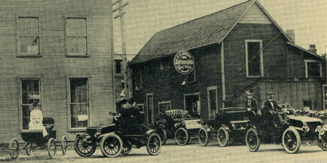
A scene in front of 1199 Franklin Avenue in the early 1900s.
1900-1909
1901
An iron bridge is completed at the Scioto River crossing of Sandusky Street. The narrow, 2-lane crossing would be almost immediately insufficient.
1910-1919
Sunday, July 30, 1911
High Street between Clintonville and Webster Park is announced to be widened to 30 feet, the same width as High south of Clintonville. The widening is to include a raised drive area for cars that will be even with the surface of the interurban tracks, allowing autos to cross High from one side to the other for the first time.
March 21-25, 1913
An enormous flood destroys the iron Broad Street bridge, along with many others along the Scioto and Olentangy rivers.
April, 1918
A new Broad Street bridge begins construction.
1920-1929
October 31, 1921
“Memorial Bridge”, the 5th Broad Street bridge over the Scioto River, is completed and dedicated at a cost of $628,000. It is a 7-span concrete structure. It is dedicated to WWI veterans.
1922
Alkire Road, on the city’s southwest side, begins construction despite heavy local resident protests. The cost of the 10.3 mile road is $270,844.
November 2, 1925
Columbus’ new traffic light system is turned on for the first time, and is considered to be the largest such system of any city in the nation at the time.
August 18, 1927
Construction for one of the city’s very first parking garages begins at 90 N. Front Street. The structure, called the Merchants Garage, is to be 6-stories in height and have a capacity of 1,000 cars during peak times.
June 4, 1928
The Front Street parking garage opens to traffic.
June 8, 1928
Columbus’ first taxi company, Green Cab Co., begins operations with 6 cars.
October, 1928
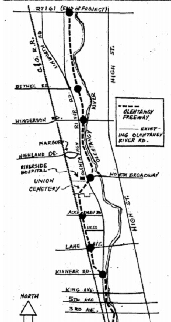
Completion of the rebuilding of the Sandusky Street right-of-way between the Scioto River bridge to Dublin Road occurs. It is the first step in a proposed “Olentangy Boulevard” that will run up the western side of the Olentangy River. Franklin County engineer, Curtis Lattimer, states that the boulevard is meant to eliminate 2 at-grade rail crossings as well as reduce congestion from through traffic. The Olentangy Boulevard is to be constructed between 5th Avenue and Sandusky Street. North of 5th, sections of an Olentangy River roadway already exist due to previous piecemeal efforts by developers who were anticipating the construction of new residential subdivisions along its route. These subdivisions were never built.
1930-1939
April 1, 1932
Removal of the East Broad parkway begins. In an ironic twist, the first tree removed, an American Elm, is replanted on the west Statehouse lawn as part of Arbor Day.
April 2, 1932
George Washington Boulevard, in front of Central High School (now COSI), is dedicated with a ceremony and the planting of more than 150 cherry trees along the riverfront.
April 14, 1938
City and State leaders meet at the Southern Hotel to discuss plans for relieving traffic at the Spring-Sandusky intersection. The dangerous intersection suffers from the confluence of the Scioto and Olentangy rivers, several railroad tracks and overpasses, and narrow roadways, underpasses and bridges. Two main plans are discussed, with one proposing to relocate part of the river itself 400 feet north to facilitate reconstruction.
April 24, 1939
Legislation is submitted to Columbus City Council to change the name of Olentangy River Road to Lattimer Boulevard, after the late County engineer Curtis Lattimer. Lattimer spearheaded the project to complete what was then known as Olentangy Boulevard. Many residents, however, are opposed to the name change and it does not occur.
1940-1949
January 4, 1941
Columbus installs 1,000 parking meters Downtown, the first in the city. The fee is 5 cents per hour 8am-6pm. The city would collect about 10,000 nickels a day from the meters over the following few days.
January 11, 1941
Ohio State Highway Director Hal G. Sours proposes legislation authorizing the construction of high-speed freeways near points of entrance to larger cities. Sours says, “A freeway system, working hardship on no one, would at the same time assure a smooth, steady movement of traffic and curtail the possibility of crossroad collisions.”
January 1, 1946
Due to increasing congestion and accidents at the Spring-Sandusky intersection, planners begin work on an update for the dangerous crossing, including starting work on a new scale model. Changes include a new Sandusky Street bridge, new overpasses, rail bridges and other improvements.
January, 1947
Senator Evert Addison proposes a bill, sponsored by the Ohio Redevelopment Commission, that would allow municipalities to condemn property and lease it to private companies to create off-street parking lots.
1948
The new Sandusky Street bridge over the Scioto River is completed. It is considered the original piece of what would become the Columbus freeway system.
April 29, 1948
Former governor Frank Lausche advocates for a 1,200-mile freeway system in the state, saying the system would “bring widespread benefits to agriculture and industry.”
1949
The federal government drafts a national plan for a 40,000-mile highway system.
1950-1959
1950
The highway that would become I-71, connecting Cleveland, Columbus and Cincinnati, is proposed.
April 10, 1951
Columbus voters approve a bond issue to fund planning and right of way purchasing of the Innerbelt freeway system.
May 16, 1951
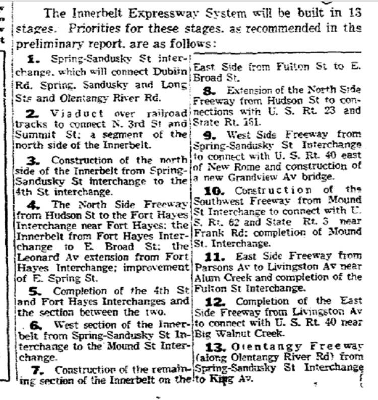
The proposed route for the Columbus freeway system is released for public review. It is to be 22-miles in length and cost $85,350,000 to build, funded by the bond issue approval in April, as well as state and federal funds. The system is proposed to be built in 13 stages, as follows from a 1951 article:
Of the proposals, the original plan for what would become I-670 calls for Leonard Avenue to be reconstructed into a major thoroughfare, though not a highway.
March 15, 1952
Plans for the new Columbus expressway system are completed, with a new projected cost of $92.8 million.
1954
Columbus has the 2nd best traffic safety record of cities its size (Population 300K-500K) in the nation when it records a traffic fatality rate of just 2 per 10,000 vehicles. The records are compiled by the National Safety Council.
January 10, 1955
The first section of a rebuilt Spring-Sandusky interchange opens to traffic.
September 1, 1957
The route for a 6.2-mile section of the “North Freeway”, or I-71, between the intersection of Cleveland Avenue/Leonard Avenue north to the the city boundary half a mile east of Sinclair Road, is approved.
1957
The Columbus Commission Annual Planning Report calls for a 6-lane, east-west freeway between Fort Hayes and the airport along Leonard Avenue, or what would become I-670. The same report calls for an additional “expressway” along 17th Avenue between I-71 and the airport.
1958
Sandusky Street, one of the oldest streets in Franklinton and Columbus, is destroyed and its route almost entirely covered with the construction of the first section of Rt. 315.
October 30, 1959
The first piece of the new freeway system, the west leg of the Innerbelt including the Scioto River bridge, is dedicated by Mayor Sensenbrenner.
1960-1969
June, 1960
The I-71 section between Park Road and Strimple Avenue is completed and opened to traffic at a cost of $2,949,951.
July, 1960
I-71 between Stimmel Road and Harrisburg is completed and opened to traffic at a cost of $9,306,857.
September, 1960
I-71 between Strimple Avenue to Maynard Avenue is completed and opened to traffic at a cost of $13,176,327.
September 25, 1960
Front Street becomes one-way going north between Spring and Main, Civic Center Drive becomes one-way going south between Main and Broad, and Marconi Boulevard becomes one-way going south between Gay and Broad. For Marconi, this is an extension from the existing one-way between Gay and Spring. These one-way changes generally last for the next 50+ years.
October 12, 1963
A compromise between officials Ohio State University officials and the State Highway Department is reached regarding the proposed route of Rt. 315 after years of dispute.
1963 map of the proposed route of 315.
1965
Columbus’ Green Cab Co. becomes United Transportation.
June 15, 1966
The first segment of the “East Freeway”, or I-70, opens from Downtown to Miller-Kelton. It is also announced that the highway will not open to Alum Creek Drive as expected and is running 2 months behind due to a Vietnam War-related shortage of copper wiring needed for highway lighting.
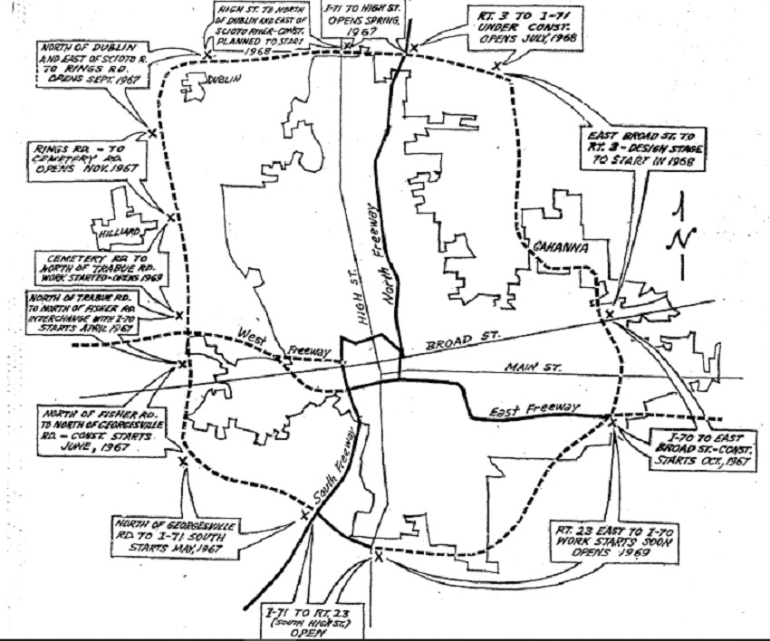
An Outerbelt (270) rendering map from 1966.
August, 1967
The second section of I-270 opens between Rt. 23 and I-71 on the North Side.
1970-1979
1972
Rt. 104 on the South Side is completed between I-71 and Lockbourne Road.
May, 1973
Reconstruction of the Mound-Sandusky interchange for I-71/I-70/Rt 315 begins at a cost of $18 million.
June 29, 1973
A proposal is made to turn Broad Street through Downtown into a landscaped boulevard for the first time since the 1930s. The proposal calls for construction of a 10-foot median strip down the center of Broad between I-71 and 315. The median would include about 70 trees with another 125 along new tree laws on the north and south sides, along with 6000 bushes. The plan also includes a pair of parks at the northeast and southeast corners of Cleveland Avenue and Broad, and on both sides of Broad just west of Veterans Memorial. The price tag for the proposal is $343,000.
September 14, 1974
Columbus asks the federal government to add a proposed highway from the convention center to the airport on a list of federally-funded highway projects. Approval would mean up to 90% of the cost would be paid for by the federal government. This request also effectively ends discussion of the proposed 17th Avenue freeway.
November, 1975
The “West Freeway”, or I-70, opens between Holton Avenue and West Broad Street. The section, which contains several ramps and bridges, costs $6.5 million.
August 17, 1976
A public meeting is held to share 3 proposed routes for the 670 highway project. Most of those in attendance are opposed to any route.
November 14, 1977
Former Columbus Mayor Maynard Sensenbrenner writes an opinion piece supporting the construction of the controversial I-670 freeway that will connect Downtown to northeastern Franklin County.
March 22, 1978
The final route of I-670 is announced, chosen from 5 potential routes, a no-build alternative and several mass transit alternatives. The proposed route requires the demolition of 211 homes, 20 businesses and a pair of parks. The cost of building the 5.27-mile proposal from Ft. Hayes to Rt 62 is $221 million.
1980-1989
1985
It is determined that salt corrosion at the base of the Broad Street bridge makes it unsafe and in need of replacement.
1987
A MORPC study concludes that Downtown parking spaces have grown from 58,160 to 66,842 since 1984.
1990-1999
January 28, 1991
Demolition of the 1921 Broad Street bridge begins.
June, 1992
The $13 million “Discovery Bridge”, the most recent Broad Street bridge iteration, is completed.
2000-2009
2005
The city pushes a plan to cover the Downtown I-70 trench with an 8-lane landscaped “grand boulevard” lined with shops in the run-up to deciding how to rebuild the I-70/I-71 split. It is one of 5 proposals.