
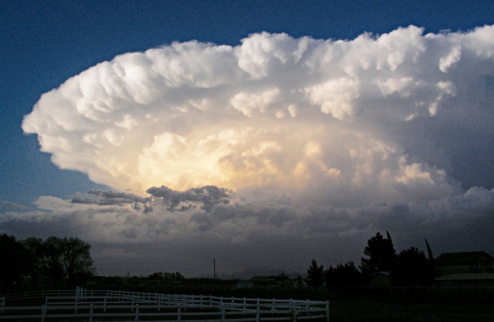
Severe weather events related to thunderstorm activity of any scale are detailed here. All events are listed in chronological order by year and date, most recent to oldest.
**Last Updated: 4/22/2025- Added 2024 severe reports.
2020-2029
2020
May 14, 2020
Showers and thunderstorms developed through the afternoon hours in association with an upper level disturbance moving through the region. Severe weather stayed north of I-70.
https://www.weather.gov/iln/20200514
May 10, 2020
Severe thunderstorms ahead of a cold front brought mostly high winds. The winds of up to 60MPH downed trees and power lines. There were 19 total severe reports.
https://www.weather.gov/iln/20200510
April 8, 2020
Thunderstorms moved through the area in the early morning, with the main story being large hail up to 1″. Strong winds generally stayed under 50MPH in the storms, producing only scattered downed limbs. 7 severe reports occurred.
https://www.weather.gov/iln/20200408
March 28, 2020
A warm front lifting north across the area brought scattered severe thunderstorms during the afternoon hours. Heavy rain, hail and high winds occurred mainly along and north of I-70. 7 severe reports occurred during the storms.
https://www.weather.gov/iln/20200328
2010-2019
2019
July 2, 2019
More than 50 reports of wind damage were reported across the area as thunderstorms developed during the afternoon hours. See details here: https://www.weather.gov/iln/20190702
April 14, 2019 Event
Several reports of high winds and wind damage from thunderstorms occurred across the area. See details here: https://www.weather.gov/iln/20190414
April 12, 2019: Thunderstorm-induced traight-line winds of 70-75MPH hit Union County at 8:57AM. See details here: https://www.weather.gov/iln/20190412_union
March 14, 2019 Event
Thunderstorms developed ahead of a cold front, bringing a wide variety of severe weather to the area. See the details here: https://www.weather.gov/iln/20190314
2018
May 21, 2018
**Coming Soon**
April 3-4, 2018
**Coming Soon**
2012
March 18, 2012
Thunderstorms developed during the afternoon on the south side of a passing system. Heavy rains brought flooding to Newark, Dublin and areas near Marysville, and winds gusted to 56MPH in Dublin. The main story of the day was hail. Hail between 1″-1.75″ in diameter fell in many locations across Central Ohio, producing scattered damage to trees, windows and siding.
2000-2009
October 4, 2006
Storms swept over the Columbus area after 6:30PM, bringing funnel clouds, heavy rain, strong winds and large hail. Hail measuring up to 1.5″ hit the West Side, Upper Arlington and Gahanna, causing several million dollars in damage to homes, cars and trees.
April 20, 2003
The Easter Sunday hail storm of 2003 is one of the most damaging the region has ever seen. Storms developed over the Indiana/Illinois border during the afternoon and raced eastward, moving into the Columbus area at around 7pm. Between 7pm and 7:30pm, hail pummeled northern Franklin and southern Delaware counties. The hail in some places was golf ball sized or larger, and in parts of Hilliard, Upper Arlington, Worthington, Dublin and Westerville, it accumulated 6 inches deep. No hail at all was reported immediately to the south and east of this swath.
Thousands of cars were dented, trees were stripped bare and siding, windows and roofs were damaged throughout the northern Columbus suburbs. Hail damages reached as high as $150 million in the region, which was still recovering a year later.
1990-1999
July 2, 1997
Thunderstorms developed in Indiana ahead of a strong cold front and quickly developed into a bow echo that moved east-southeast from the northern Miami Valley into Columbus. The bow echo caused damaging winds of 60MPH-70MPH across Central Ohio.
In Delaware County, 70MPH winds ripped the roof off a barn and downed trees between Delaware and Sunbury.
Outside of Plain City, another barn lost its roof, while power lines and trees were blown down countywide.
The story was similar in Fairfield, Franklin, Licking and Hocking counties, with numerous trees and power lines downed, along with minor structural damage to some buildings.
May 18, 1997
This was a very active severe weather day across Ohio. In all, there were 62 severe weather reports, with all but one being hail or thunderstorm wind. In Central Ohio, the severe weather moved through between 2PM-4PM.
Lewis Center in Delaware County reported 0.75″ hail at 2:15PM along Lewis Center Road.
The west side of Iberia in northern Morrow County reported 1″ hail at 3:35PM.
In Madison County between London and Rosedale, winds of 60MPH knocked down trees on roads and some homes at around 4:30PM.
Marysville in Union County was also hit with 60MPH winds, blowing down numerous trees there.
At around 5PM, Delaware was hit by 70MPH winds, damaging 6 homes from falling trees.
Columbus and Franklin County were also hit by 70MPH winds around 5:20PM, producing tree damage and destroying a barn.
The final severe report in Central Ohio occurred at 6:30PM when 1″ hail fell on Crooksville in Perry County.
May 14, 1997
Afternoon thunderstorms brought wind and hail to Central Ohio. In Canal Winchester, winds of up to 60MPH knocked down numerous trees, blocking several roads.
https://www.ncdc.noaa.gov/stormevents/eventdetails.jsp?id=5603555https://www.ncdc.noaa.gov/stormevents/eventdetails.jsp?id=5603555https://www.ncdc.noaa.gov/stormevents/eventdetails.jsp?id=5603555
Hail was the most common severe weather report, however. 0.75″ hail fell across Grove City and Whisler in far southern Pickaway County, with it reaching 1.25″ in diameter at Laurelville in Hocking County. Damage was not widespread.
May 3, 1997
Thunderstorms developed just east and north of Columbus around Noon. They produced winds up to 70MPH around Pataskala, knocking down numerous trees. In Chesterville in Morrow County, thunderstorm winds destroyed a machine shed and took the roof off a barn.
0.88″ hail fell on the far east side of Pataskala just before 10AM.
January 5, 1997
A line of severe thunderstorms moving at 50MPH prompted severe thunderstorm warnings throughout Central Ohio between 1AM-2AM, bringing damaging winds. Winds gusted to 58MPH in parts of Franklin, Delaware, Madison, Licking and Fairfield counties, downing trees and causing mostly minor damage. Major damage, however, occurred at about 1:30AM in Dublin and areas to the northeast when a microburst produced wind gusts to nearly 100MPH. One of the worst-hit neighborhoods was Summit View Woods, where a 3-block area was heavily damaged. 8 homes sustained major structural damage with 37 more having at least minor damage. Numerous trees were downed, chimneys were toppled, fences and sheds destroyed and windows shattered. A child was injured when debris burst through their bedroom window, cutting their leg. Damage in the neighborhood exceeded $1 million.
May 5, 1996
0.75″ hail occurred in Clintonville between 1:21PM-1:25PM.
1980-1989
May 9, 1988
Several areas around the Columbus region experienced hail up to 1.25″ in size during the afternoon. 0.75″ hail fell at Port Columbus, briefly delaying flights. Damage was not widespread.
June 3, 1980
Rounds of severe thunderstorms moved through Central Ohio Monday morning and afternoon. Hail fell in Madison, Franklin and Fairfield counties that reached up to 2″ in diameter, particularly in Columbus, damaging homes, trees and property. The main story was heavy rain, as up to 5″ hit parts of the area, flooding roads and basements, and local streams overflowed their banks.

Flooded campgrounds near Griggs Dam after the storms of June 2, 1980.
1970-1979
May 23, 1970
Multiple rounds of thunderstorms struck the Columbus area during the afternoon, bringing high winds, heavy rain and a damaging hail storm. The first storm hit northern parts of Franklin County at about 3:25pm. Upper Arlington received hail up to 1″ in diameter. The hail damaged trees, vehicles and broke out some windows. A secondary storm moved across the city at around 6pm with a more widespread, but less damaging pea-size hail.
1960-1969
May 28, 1960
Just before noon, the East Side from Bexley north to Agler Road in Linden was hit with an isolated storm that brought heavy rain and hail up to half an inch in diameter. The hail storm lasted up to 15 minutes in the area, pounding gardens and trees, and in some areas, covering the ground completely like a blanket of snow. The hail blocked some sewer drains, causing backups as up to 1.5″ of rain fell in 20 minutes.
1950-1959
April 5, 1957
A week of severe weather culminated in a severe squall line that produced hurricane force winds across Columbus. In an event that was most likely caused by a derecho-type system, a line of severe storms raced south-eastward across the area. Winds gusted to at least 80MPH across the city between about 2:30PM-3PM. Trees and power lines were downed areawide. At Great Southern Shopping Center, the walls of a storeroom under construction were destroyed.
July 3, 1955
Several thunderstorms developed in the Columbus area in the early afternoon. A storm in Delaware County produced lightning that killed 4 members of a family hiding under a tree. In Columbus, strong winds “like a mini tornado” struck the Bexley area, blocking at least a dozen streets with downed trees and damaging some homes.
June 21, 1955
A sudden storm blew up over the North Side of Columbus between 3PM-4PM on Wednesday afternoon. The storm brought hail as big as 1.75″ in diameter, stripping trees of their leaves “like it was October”. The storm also brought high winds and heavy rain that flooded some streets.
March 11, 1955
A strong thunderstorm hit the Columbus area between 4:15AM-5AM on Friday morning. While the storm brought heavy rain, hail and lightning- which burned out transit lines on Cleveland Avenue- the main story was the wind. Across the city, winds topped 70mph, blowing out windows and downing trees and power lines. Electricity was knocked out to large sections of the city and county. Traffic was hampered throughout the early morning by roads blocked by trees and debris. A skylight at the Statehouse was blown off and several buildings, including the Downtown Lazarus and Town & Country Shopping Center, had windows blown out.
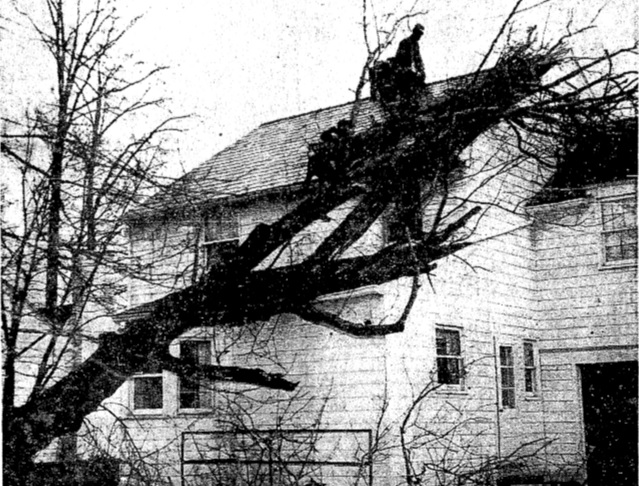
Wind damage from the 3/11/1955 storm.
1920-1929
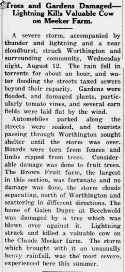
August 12, 1925
As told in the article clips and links below, the Columbus area- particularly the North Side- was hit by a damaging severe thunderstorm during the afternoon. The storm damaged trees and property, and many streets were made impassible from deep flash flooding.
Columbus Dispatch 8-13-1925 Part 1
Columbus Dispatch 8-13-1925 Part 2
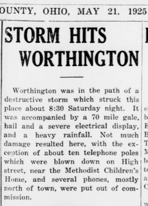
May 16, 1925
A storm struck much of the Columbus area on Saturday evening, bringing damaging lightning, strong winds and flooding.
Columbus Dispatch 5-17-1925 Part 1
Columbus Dispatch 5-17-1925 Part 2
June 22, 1921
Per the Ohio Climatological Record: “On the 22nd, severe local storms accompanied by excessive rainfall occurred in Athens, Madison and Pickaway counties, with the loss of crops, buildings and coal mines at Amesville, Athens County, being estimated at more than $100,000.”
1910-1919
February 15, 1919
Light hail is reported in several areas of the city.
October 18, 1918
Dense smoke from Minnesota forest fires moved into Ohio during the late morning and afternoon. It entered the Columbus area after Noon and spread across Columbus through 1pm. The sky was reported to be a rusty brown to blood-red in color, and the smell of burning wood was pronounced.
September 12, 1918
Thunderstorms brought moderate to severe hail to parts of Ohio. Moderate hail fell in Franklin County, where some windows were broken and light damage occurred to trees and crops.
August 12, 1918
A severe thunderstorm developed directly over Columbus with exceptionally high, but localized winds. The Weather Bureau in Columbus reported a maximum wind speed of 68MPH, with a gust to 102MPH. The greatest wind damage occurred in and around Ohio State University, where buildings were damaged and numerous trees were blown down.
The Columbus Dispatch detailed the August 12, 1918 storm in detail.
August 11, 1918
Light hail and strong winds were reported across southeastern Franklin County as thunderstorms moved through. Power lines were damaged in some parts of the city by high winds.
1890-1899
May 18, 1890
A severe storm brought very strong winds to the northern end of Columbus at around 4PM. At Elizabeth Street near Harbor Road, a 2 story frame house under construction was blown apart. 6 boys seeking shelter inside were injured by falling bricks. Another house just to the north on E. 3rd Avenue was blown off its foundation about 5 inches. East of these homes, trees as large as 2.5 feet in diameter were snapped. It’s possible a small tornado occurred at these locations.
Additional damage occurred to trees along East Broad Street, McMillan Avenue and other places throughout the city, and large hailstones were reported across North Columbus, causing many trees to be stripped of their leaves.
1870-1879
July 4, 1873
In what was reported to be a very active severe weather week for parts of Indiana and Ohio, a strong thunderstorm moved through Columbus at around 2AM. Strong winds were said to have left the city “strewn with limbs of trees”, with telegraph wires downed on Friend Street (Main Street).
Elsewhere, at Etna, a bridge over the National Road washed away and hail was reported nearby that was said to have measured “seven inches in circumference”, causing damage to some houses.
Chart of Ohio Severe Weather Reports by Type by Year 1950-2024
Severe Type | 1950 | 1951 | 1952 | 1953 | 1954 | 1955 | 1956 | 1957 | 1958 | 1959 | 1960 | 1961 | 1962 | 1963 | 1964 | 1965 | 1966 | 1967 | 1968 | 1969 | 1970 | 1971 | 1972 | 1973 | 1974 | 1975 | 1976 | 1977 | 1978 | 1979 | 1980 | 1981 | 1982 | 1983 | 1984 | 1985 | 1986 | 1987 | 1988 | 1989 | 1990 | 1991 | 1992 | 1993 | 1994 | 1995 | 1996 | 1997 | 1998 | 1999 | 2000 | 2001 | 2002 | 2003 | 2004 | 2005 | 2006 | 2007 | 2008 | 2009 | 2010 | 2011 | 2012 | 2013 | 2014 | 2015 | 2016 | 2017 | 2018 | 2019 | 2020 | 2021 | 2022 | 2023 Preliminary | 2024 Preliminary |
Tornadoes | 3 | 3 | 2 | 4 | 13 | 7 | 9 | 4 | 13 | 10 | 7 | 19 | 4 | 19 | 9 | 33 | 3 | 6 | 14 | 17 | 23 | 15 | 10 | 44 | 23 | 12 | 10 | 22 | 18 | 4 | 35 | 26 | 10 | 9 | 2 | 25 | 23 | 6 | 0 | 17 | 24 | 9 | 61 | 24 | 9 | 8 | 10 | 15 | 24 | 18 | 26 | 8 | 25 | 13 | 8 | 4 | 36 | 12 | 13 | 13 | 41 | 39 | 13 | 30 | 20 | 7 | 24 | 42 | 30 | 49 | 21 | 31 | 27 | 56 | 28 |
Wind | 0 | 0 | 0 | 0 | 0 | 4 | 7 | 7 | 12 | 8 | 7 | 11 | 6 | 5 | 7 | 16 | 32 | 17 | 56 | 30 | 29 | 39 | 4 | 76 | 102 | 42 | 56 | 32 | 24 | 27 | 109 | 69 | 178 | 207 | 69 | 83 | 187 | 167 | 85 | 169 | 233 | 253 | 285 | 319 | 419 | 427 | 116 | 183 | 423 | 257 | 299 | 159 | 384 | 764 | 424 | 491 | 466 | 454 | 533 | 234 | 652 | 804 | 712 | 838 | 325 | 536 | 381 | 618 | 856 | 889 | 900 | 436 | 708 | 616 | 57 |
Hail | 0 | 0 | 0 | 0 | 0 | 1 | 6 | 5 | 1 | 5 | 7 | 4 | 13 | 8 | 3 | 6 | 14 | 8 | 11 | 7 | 17 | 10 | 9 | 10 | 42 | 13 | 11 | 12 | 4 | 2 | 87 | 21 | 85 | 71 | 21 | 76 | 34 | 17 | 26 | 23 | 38 | 34 | 34 | 38 | 69 | 65 | 36 | 23 | 147 | 51 | 87 | 86 | 146 | 75 | 84 | 37 | 89 | 84 | 78 | 105 | 189 | 411 | 263 | 185 | 192 | 90 | 78 | 120 | 104 | 139 | 132 | 36 | 82 | 66 | 38 |
Total | 3 | 3 | 2 | 4 | 13 | 12 | 22 | 16 | 26 | 23 | 21 | 34 | 23 | 32 | 19 | 55 | 49 | 31 | 81 | 54 | 69 | 64 | 23 | 130 | 167 | 67 | 77 | 66 | 46 | 33 | 231 | 116 | 273 | 287 | 92 | 184 | 244 | 190 | 111 | 209 | 295 | 296 | 380 | 381 | 497 | 500 | 162 | 221 | 594 | 326 | 412 | 253 | 555 | 852 | 516 | 532 | 591 | 550 | 624 | 352 | 882 | 1254 | 988 | 1053 | 537 | 633 | 483 | 780 | 990 | 1077 | 1053 | 503 | 817 | 738 | 123 |
Top 25 Most Active Severe Weather Days since 1980
Rank | Date | Tornado | Wind | Hail | Total Reports |
1 | 6/29/2012 | 0 | 253 | 16 | 269 |
2 | 7/10/2013 | 5 | 190 | 18 | 213 |
3 | 6/10/2020 | 3 | 193 | 2 | 198 |
4 | 6/13/2022 | 4 | 177 | 3 | 184 |
5 | 5/25/2011 | 8 | 54 | 109 | 171 |
6 | 4/8/2020 | 7 | 64 | 63 | 134 |
7 | 11/10/2002 | 19 | 68 | 48 | 131 |
8 | 7/8/2003 | 0 | 121 | 10 | 131 |
9 | 11/17/2013 | 6 | 123 | 0 | 129 |
10 | 5/21/2004 | 1 | 78 | 49 | 128 |
11 | 6/22/2006 | 10 | 78 | 38 | 126 |
12 | 6/12/2013 | 10 | 74 | 42 | 126 |
13 | 7/1/2012 | 0 | 79 | 40 | 119 |
14 | 7/2/2019 | 0 | 113 | 5 | 118 |
15 | 5/25/2006 | 0 | 69 | 45 | 114 |
16 | 4/3/2018 | 10 | 42 | 60 | 112 |
17 | 4/9/2001 | 1 | 15 | 94 | 110 |
18 | 11/15/2020 | 0 | 109 | 1 | 110 |
19 | 6/15/1982 | 1 | 84 | 22 | 107 |
20 | 5/15/2014 | 1 | 15 | 91 | 107 |
21 | 7/11/2011 | 0 | 73 | 31 | 104 |
22 | 4/1/2023 | 0 | 103 | 1 | 104 |
23 | 5/23/2011 | 4 | 88 | 11 | 103 |
24 | 5/7/2010 | 1 | 33 | 66 | 100 |
25 | 6/25/2013 | 0 | 58 | 41 | 99 |
To see more severe weather history in Central Ohio, check out these pages:
Columbus Tornado History
Thunderstorm Wind
Floods
Here’s a US map of all severe weather reports 1950-2021. It unfortunately does not give specific dates for events, but rather it just shows the type of event by location.