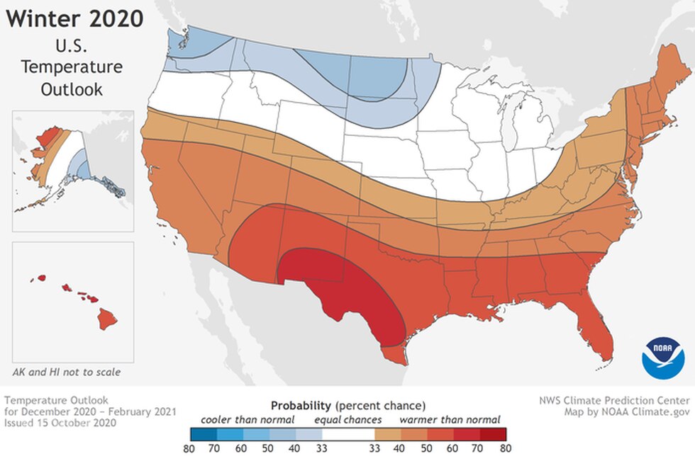
The NOAA temperature outlook for winter 2020-2021.
The Winter 2020-2021 Review is the latest edition in the series. Overall, December and February brought some of the worst winter weather Columbus had seen in several years. Meanwhile, January and March were unusually quiet. Temperatures through January were fairly to slightly above average, while February was well below normal. March and April provided little winter weather, and March had no snowfall whatsoever.
Let’s break the winter down.
December-February Only
Average High: 37.8 42nd Coldest
Average Low: 25.1 34th Warmest
Mean: 31.4 42nd Warmest
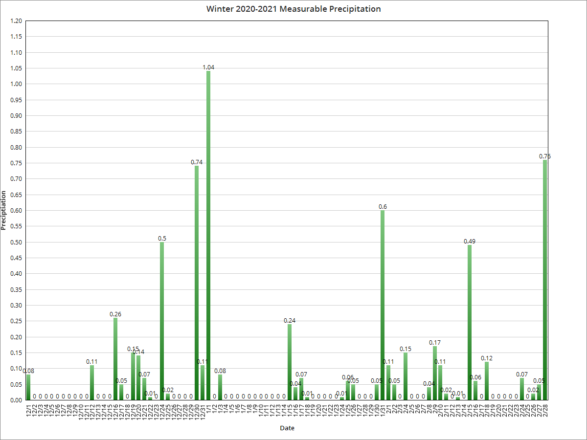
Precipitation: 6.72″ 38th Driest
Snowfall: 24.7″ 31st Snowiest
Average Daily Snow Depth: 1.0″ 15th Highest
Largest Snowstorm: 5″ on 1/30-2/1/2021. This was a long-duration storm that moved only very slowly through the region.
# of 32 or Below Highs: 28 22nd Most
# of 32 or Below Lows: 79 10th Most
# of Measurable Precipitation Days: 38 14th Fewest
# of Measurable Snowfall Days: 23 14th Most
Overall, winter 2020-21 was somewhat average- not too cold, not too warm, not too wet, not too dry, not too snowy, but not snowless.
Entire Cold Season: October-April
Average High: 51.2 15th Warmest
Average Low: 33.6 22nd Warmest
Mean: 42.4 15th Warmest
Precipitation: 20.39″ 56th Wettest
Snowfall: 27.8″ 43rd Snowiest
Average Snow Depth: 0.4″ 5th Lowest
Largest Snowstorm: 5″ on 1/30-2/1/2021
# of 32 or Below Highs: 28 18th Fewest
# of 32 or Below Lows: 107 27th Most
# of Measurable Precipitation Days: 76 11th Fewest
# of Measurable Snowfall Days: 25 16th Fewest
The overall cold season was generally warm, but still managed to provide near normal to slight above normal snowfall for the region.
Average High By Month
October 2020: 63.3 31st Coldest
November 2020: 57.6 8th Warmest
December 2020: 41.5 38th Warmest
January 2021: 37.5 49th Warmest
February 2021: 33.9 20th Coldest
March 2021: 59.0 7th Warmest
April 2021: 64.4 29th Warmest
Average Low By Month
October 2020: 45.6 35th Warmest
November 2020: 37.3 18th Warmest
December 2020: 27.7 36th Warmest
January 2021: 26.6 22nd Warmest
February 2021: 20.4 35th Coldest
March 2021: 34.7 27th Warmest
April 2021: 42.0 35th Warmest
Mean By Month
October 2020: 54.5 38th Coldest
November 2020: 47.4 10th Warmest
December 2020: 34.6 36th Warmest
January 2021: 32.1 39th Warmest
February 2021: 27.2 30th Coldest
March 2021: 46.9 12th Warmest
April 2021: 53.2 28th Warmest
Precipitation By Month
October 2020: 4.19″ 16th Wettest
November 2020: 3.35″ 45th Wettest
December 2020: 2.24″ 44th Driest
January 2021: 2.25″ 50th Driest
February 2021: 2.23″ 64th Wettest
March 2021: 2.85″ 54th Driest
April 2021: 3.28″ 60th Wettest
Snowfall By Month
October 2020: 0.0″ Tied for Least Snowy
November 2020: 1.9″ 21st Least Snowy
December 2020: 8.5″ 22nd Snowy
January 2021: 4.1″ 29th Least Snowy
February 2021: 12.1″ 15th Snowiest
March 2021: 0.0″ Tied for Least Snowy
April 2021: 1.2″ 14th Least Snowy
March’s lack of snowfall tied the record for the only time in history the month did not even have a trace of snowfall.
Average Snow Depth By Month
October 2020: 0.0″
November 2020: 0.0″
December 2020: 0.7″
January 2021: 0.1″
February 2021: 2.4″
March 2021: 0.0″
April 2021: 0.0″
Maximum High By Month
October 2020: 80 on the 22nd
November 2020: 78 on the 8th and 10th
December 2020: 63 on the 11th
January 2021: 51 on the 1st
February 2021: 60 on the 28th
March 2021: 75 on March 24th
April 2021: 83 on April 27th
Maximum High Records
-78 on November 8th was a record high for the date, beating the old record of 74 set in 1945.
-76 on November 9th tied the daily record high with 1975.
-78 on November 10th was a record high for the date, beating the old record of 72 set in 1949.
Minimum High By Month
October 2020: 48 on the 30th
November 2020: 43 on the 18th
December 2020: 18 on the 25th
January 2021: 25 on the 28th
February 2021: 23 on the 7th and 16th
March 2021: 40 on the 15th
April 2021: 37 o the 1st
Maximum Low By Month
October 2020: 62 on the 11th
November 2020: 55 on the 10th
December 2020: 43 on the 12th
January 2021: 37 on the 2nd
February 2021: 43 on the 28th
March 2021: 56 on the 11th
April 2021: 65 on the 28th
Maximum Low Records
-The 65 on April 28th tied the record set in 1914.
Minimum Low By Month
October 2020: 30 on the 31st
November 2020: 25 on the 18th
December 2020: 13 on the 26th and 27th
January 2021: 16 on the 23rd
February 2021: 5 on the 17th
March 2021: 19 on the 5th
April 2021: 21 on the 2nd
Highest Daily Precipitation By Month
October 2020: 1.25″ on the 29th
November 2020: 0.89″ on the 25th
December 2020: 0.74″ on the 30th
January 2021: 1.04″ on the 1st
February 2021: 0.76″ on the 28th
March 2021: 1.12″ on the 18th
April 2021: 1.88″ on the 29th
Precipitation Records
-0.76″ on February 28th was the record for the date, beating the old record of 0.56″ set in 1954.
-The 1.88″ on April 29th was a record for the date, beating the old record of 1.82″ set in 1996.
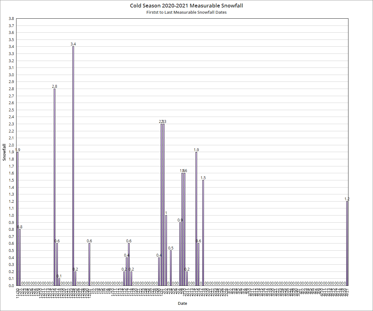
Highest Daily Snowfall By Month
October 2020: 0.0″
November 2020: 1.9″ on the 30th
December 2020: 3.4″ on the 24th
January 2021: 2.3″ on the 31st
February 2021: 2.3″ on the 1st
March 2021: 0.0″
April 2021: 1.2″ on the 21st
Snowfall Records
-2.8″ on December 16th was a record for the date, beating the old record of 1.8″ set in 1953.
-3.4″ on December 24th was a record for the date, beating the old record of 2.7″ set in 1980.
Deepest Snow Depth By Month
October 2020: 0″
November 2020: 0″
December2020: 4″ on the 26th
January 2021: 3″ on the 31st
February 2021: 5″ on the 18th-21st
March 2021: 0.0″
April 2021: 1″ on the 21st
Winter 2020-2021 Daily Graphs

For more winter records and local weather information, visit the following links.
Winter Season Records
Wilmington National Weather Service
Other Recent Winter Season Reviews
Winter 2019-2020
Winter 2018-2019
Winter 2017-2018