The new Winter 2025-2026 Review reveals that the winter was the first snowier than normal winter since 2017-2018. It also featured the first 6″+ snow event since the winter of 2014-2015, with one of the biggest snowstorms of all-time on January 25th. It also featured generally below-normal temperatures for the core of the winter, followed by a very warm spring.
Temperatures
Average High Temperature
October: 67.7
November: 51.6
December: 39.8
January: 32.7
February: 40.5
March: 60.4
April: 71.6
Cold Season Average High: 52.1
Cold Seasond Average High Departure: +1.8
Winter Season Average High: 37.6
Winter Season Average High Departure: -2.3
Mean High Departure from Normal
October: +2.2
November: -0.7
December: -1.7
January: -4.4
February: -0.3
March: +9.3
April: +7.5
Average Low Temperature
October: 46.8
November: 34.1
December: 23.8
January: 15.7
February: 22.4
March: 38.5
April: 48.4
Cold Season Average Low: 32.9
Cold Season Average Low Departure: +0.4
Winter Season Average Low: 20.6
Winter Season Average Low Departure: -4.0
Mean Low Departure from Normal
October: +2.0
November: -0.9
December: -3.8
January: -6.3
February: -0.4
March: +6.5
April: +6.2
Mean Temperature
October: 57.3
November: 42.9
December: 31.8
January: 24.2
February: 31.5
March: 49.5
April: 60.0
Cold Season Average Mean: 42.5
Cold Season Average Mean Departure: +1.0
Winter Season Average Mean: 29.1
Winter Season Average Mean Departure: -3.1
Mean Departure from Normal
October: +2.1
November: -0.7
December: -2.7
January: -5.4
February: -1.0
March: +7.9
April: +6.8
Coldest High Temperature
October: 51 on the 22nd and 30th
November: 33 on the 10th
December: 18 on the 14th
January: 12 on the 28th
February: 19 on the 5th
March: 27 on the 17th
April: 46 on the 7th
Coldest Low Temperature
October: 34 on the 24th and 25th
November: 19 on the 29th
December: 1 on the 15th
January: -9 on the 31st
February: 0 on the 2nd
March: 20 on the 17th and 18th
April: 29 on the 8th
Coldest Mean Temperature
October: 46 on the 24th and 30th
November: 28.5 on the 10th and 29th
December: 10 on the 15th
January: 2 on the 28th
February: 10.5 on the 5th
March: 23.5 on the 17th
April: 38.5 on the 7th
Warmest High Temperature
October: 85 on the 4th
November: 67 on the 5th
December: 68 on the 28th
January: 65 on the 9th
February: 65 on the 18th
March: 86 on the 22nd
April: 84 on the 14th and 15th
Warmest Low Temperature
October: 59 on the 7th
November: 49 on the 15th
December: 40 on the 28th
January: 39 on the 9th
February: 48 on the 18th
March: 62 on the 31st
April: 67 on the 3rd and 13th
Warmest Mean Temperature
October: 70.5 on the 3rd and 4th
November: 57.5 on the 15th
December: 54 on the 28th
January: 52 on the 9th
February: 56.5 on the 18th
March: 70.5 on the 31st
April: 74.5 on the 15th
Temperature Records
October
None
November
None
December
A record daily high was tied on the 28th. The high of 68 degrees tied the previous record set in 1984.
January
A record daily high was set on the 9th. The high of 65 degrees broke the old record of 62 set in 1946 and 1949.
A record daily low was set on the 31st. The low of -9 degrees broke the old record of -6 set in 2004.
The period of January 24-January 31st featured 8 consecutive highs below 20 degrees. This ties the record for the longest such consecutive streak, matching similar records set 1/10-1/17/1893 and 2/6-2/13/1899.
February
None
March
A daily record warm low was set on the 7th. The low of 59 degrees broke the old record of 56 set in 1974.
A daily record warm low was set on the 10th. The low of 56 degrees broke the old record of 53 set in 1879.
A daily record high was set on the 22nd. The high of 86 degrees broke the old record of 85 set in 2012. This also broke the record for the warmest temperature ever recorded in March.
A daily record warm low was set on the 31st. Thg low of 62 degrees broke the old record of 61 set in 1998.
April
A daily record warm low was set on the 3rd. The low of 67 degrees broke the old record of 58 set in both 1892 and 1963.
A daily record warm low was set on the 13th. The low of 67 degrees broke the old record of 63 set in 2018.
A daily record warm low was set on the 14th. The low of 63 degrees broke the old record of 61 set in 1941.
A daily record high was tied on the 15th. The high of 84 degrees tied the old record of 84 set in 2010.
A daily record warm low was set on the 15th. The low of 65 degrees broke the old record of 62 set in both 1912 and 1941.
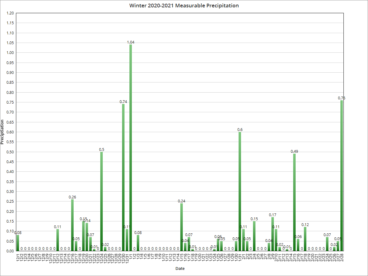
Precipitation
Total Precipitation Days
October: 7
November: 16
December: 19
January: 21
February: 14
March: 18
April: 19
Monthly Precipitation Total
October: 3.88″
November: 2.32″
December: 2.50″
January: 1.63″
February: 2.27″
March: 5.62″
April: 3.09″
Cold Season Total: 21.31″
Winter Season Total: 6.40″
Monthly Precipitation Departure from Normal
October: +0.98″
November: -0.57″
December: -0.63″
January: -1.37″
February: -0.14″
March: +2.00″
April: -0.76″
Cold Season Departure from Normal: -0.49″
Winter Season Departure from Normal: -2.14″
Greatest Precipitation
October: 1.84″ on the 7th
November: 0.70″ on the 25th
December: 0.60″ on the 18th
January: 1.09″ on the 25th
February: 1.14″ on the 19th
March: 1.03″ on the 27th
April: 0.80″ on the 22nd
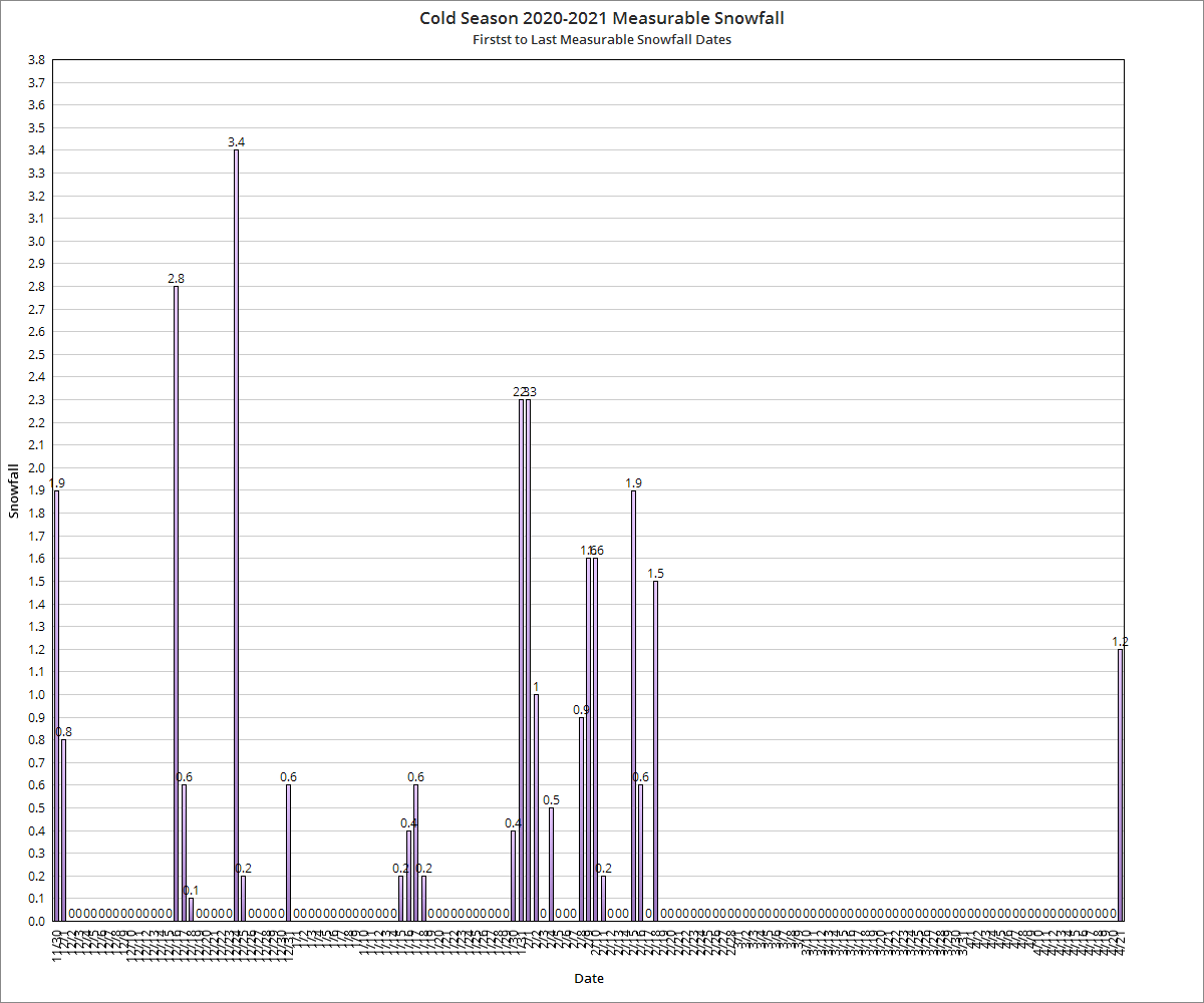
Monthly Snowfall
October: 0″
November: 1.8″
December: 12.2″
January: 13.1″
February: 3.2″
March: 3.6″
April: 0″
Cold Season Total: 33.9″
Winter Season Total: 28.5″
Monthly Snowfall Departure from Normal
October: -0.2″
November: +0.6″
December: +7.1″
January: +3.6″
February: -4.4″
March: -0.5″
April: -0.5″
Cold Season Snowfall Departure: +5.7″
Winter Season Departure from Normal: +6.3″
Greatest Snowfall
October: 0″
November: 1.3″ on the 10th
December: 5.4″ on the 13th
January: 11.9″ on the 25th
February: 1.5″ on the 6th
March: 3.0″ on the 2nd
April: 0″ on All Days
Precipitation Records
October
10/7/2025: Record daily precipitation of 1.84″, breaking the old record of 1.61″ set in 1998.
November
None
December
12/2/2025: Record daily snowfall of 4.7″, breaking the old record of 3.0″ set in 1936.
12/13/2025: Record daily snowfall of 5.4″, breaking the old record of 3.6″ set in 1945.
January
1/25/2026: Record daily snowfall of 11.9″, breaking the old record of 4.7″ set in 1988.
1/25/2026: Record daily precipitation of 1.09″, breaking the old record of 0.68″ set in 1952.
February
None
March
None
April
None
Largest Measurable Snowfalls by Date
1. 1/25/2026: 11.9″
2. 12/13/2025: 5.4″
3. 12/2/2025: 4.7″
4. 3/2/2026: 3.0″
5. 12/31/2025: 1.6″
6. 2/6/2026: 1.5″
7. 11/10/2025: 1.3″
8. 2/22/2026: 0.9″
9. 2/23/2026: 0.7″
10. 11/9/2025, 12/30/2025: 0.5″
11. 3/17/2026: 0.4″
12. 1/15/2026: 0.3″
13. 1/19/2026, 1/22/2026, 1/26/2026, 3/16/2026: 0.2″
14. 1/1/2026, 1/17/2026, 1/24/2026, 2/25/2026: 0.1″
December 2, 2025 Event
December 13, 2025 Event
January 25, 2026 Event
Total Snow Days
October: 0
November: 9
December: 12
January: 16
February: 10
March: 6
April: 0
Deepest Snow Depth
October: 0
November: 1″ on the 10th
December: 5″ on the 2nd and 14th
January: 12″ on the 26th
February: 8″ on the 1st, 2nd and 3rd
March: 2″ on the 2nd
April: 0″ on All Days
Days with Snow Depth of 1″+
October: 0
November: 1
December: 11
January: 9
February: 14
March: 1
April: 0
Average Daily Snow Depth by Month
October: 0
November: Trace
December: 1.1″
January: 2.3″
Feburary: 2.5″
March: 0.1″
April: 0″
Average Daily Wind Speed in MPH
October: 6.8
November: 8.2
December: 9.2
January: 9.8
February: 7.6
March: 10.4
April: 9.9
Highest Wind Gust in MPH
October: 42 on the 21st
November: 43 on the 5th and 26th
December: 51 on the 29th
January: 49 on the 19th
February: 60 on the 20th
March: 69 on the 22nd
April: 54 on the 14th
Clear Days by Month
October: 10
November: 4
December: 1
January: 2
February: 2
March: 2
April: 2
Partly Cloudy Days by Month
October: 16
November: 15
December: 12
January: 10
February: 18
March: 14
April: 19
Cloudy Days by Month
October: 5
November: 11
December: 18
January: 19
February: 8
March: 15
April: 9