Winter 2021-2022 Review


Winter 2021-2022 Review Columbus, Ohio

Time for the Winter 2021-2022 review! Overall, this past winter was much warmer than normal, but almost entirely because of a scorching December. This brought only about 50% of normal snowfall for the season despite being one of the wettest winters on record. This review includes new data not given for past winter reviews- wind and cloud information.

December-February Only
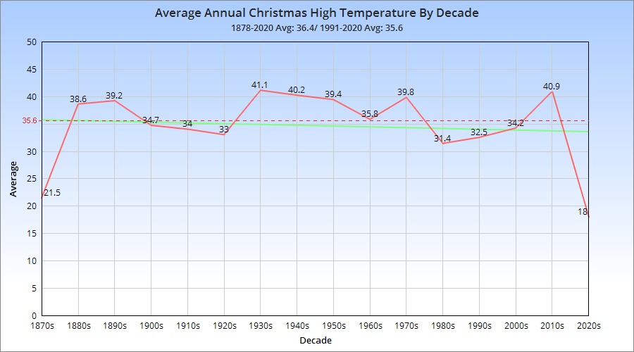
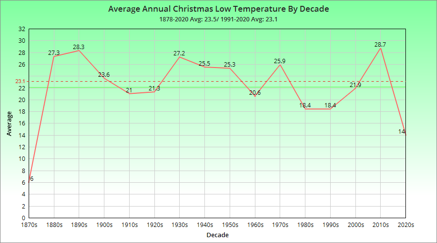
Average High: 41.7 Tied for 19th Warmest
Average Low: 24.7 Tied for 38th Warmest
Mean: 33.2 Tied for 27th Warmest
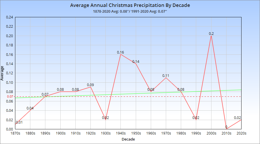
Precipitation: 13.24″ 6th Wettest
Snowfall: 11.6″ Tied for 32nd Least Snowy
Average Daily Snow Depth: 0.4″ Tied for 5th Lowest
Largest Snowstorm: 4.5″ on 2/3-2/4.
# of 32 or Below Highs: 26 Tied for 20th Fewest
# of 32 or Below Lows: 69 Tied for 17th Fewest
# of Measurable Precipitation Days: 33 Tied for 9th Fewest
# of Measurable Snowfall Days: 12 Tied for 8th Fewest
Highest Average Daily Wind Speed in MPH: 18.6 on January 5th
Highest Wind Gust in MPH: 54 on December 11th
# of Clear Days: 11 12.2%
# of Partly Cloudy Days: 43 47.8%
# of Cloudy Days: 36 40.0%

The core of the winter was warm and wet, but with relatively few precipitation days that just brought higher individual totals. Snowfall was way below normal for the period, with no snow events at or above 6″ for the 6th winter in a row. The last time a snow event dropped at least 6″ was on February 21, 2015. 6″ events, historically, have occurred about every 2 years, so in the last 7 years, Columbus should’ve had at least three.

Entire Cold Season: October-April
Average High: 52.1 Tied for 8th Warmest
Average Low: 33.7 Tied for 21st Warmest
Mean: 42.9 Tied for 12th Warmest
Precipitation: 24.32″ Tied for 20th Wettest
Snowfall: 14.5″ 27th Lowest
Average Snow Depth: 0.2″ Tied for 3rd Lowest
Largest Snowstorm: 4.5″ on 2/3-2/4
# of 32 or Below Highs: 27 Tied for 17th Fewest
# of 32 or Below Lows: 100 Tied for 19th Fewest
# of Measurable Precipitation Days: 82 Tied for 17th Fewest
# of Measurable Snowfall Days: 17 Tied for 8th Fewest
Highest Average Daily Wind Speed in MPH: 18.6 on January 5th
Highest Wind Gust in MPH: 54 on December 11th
# of Clear Days: 23 10.8%
# of Partly Cloudy Days: 105 49.6%
# of Cloudy Days: 84 39.6%

The overall cold season was very warm and wet just as the core winter was, with a very warm October and December.

Average High By Month
October 2021: 70.6 Tied for 10th Warmest
November 2021: 50.9 Tied for 47th Coldest
December 2021: 50.5 3rd Warmest
January 2022: 33.5 Tied for 30th Coldest
February 2022: 41.2 Tied for 35th Warmest
March 2022: 56.8 Tied for 11th Warmest
April 2022: 60.1 Tied for 36th Coldest

Average Low By Month
October 2021: 53.9 1st Warmest
November 2021: 32.7 Tied for 25th Coldest
December 2021: 33.1 9th Warmest
January 2022: 17.2 28th Coldest
February 2022: 23.7 55th Coldest
March 2022: 33.8 35th Warmest
April 2022: 40.9 Tied for 32nd Coldest

Mean By Month
October 2021: 62.2 Tied for 3rd Warmest
November 2021: 41.8 Tied for 33rd Coldest
December 2021: 41.8 4th Warmest
January 2022: 25.3 29th Coldest
February 2022: 32.5 46th Warmest
March 2022: 45.3 Tied for 20th Warmest
April 2022: 50.5 Tied for 34th Coldest

Precipitation By Month
October 2021: 3.57″ Tied for 28th Wettest
November 2021: 1.90″ 40th Driest
December 2021: 4.51″ 13th Wettest
January 2022: 2.61″ 59th Wettest
February 2022: 6.12″ Tied for 4th Wettest
March 2022: 2.29″ 37th Driest
April 2022: 3.32″ 58th Wettest

Snowfall By Month
October 2021: 0.0″ Tied for 1st Least Snowy
November 2021: 0.6″ Tied for 8th Least Snowy
December 2021: 0.5″ Tied for 7th Least Snowy
January 2022: 6.3″ Tied for 45th Least Snowy
February 2022: 4.8″ Tied for 35th Least Snowy
March 2022: 2.2″ Tied for 22nd Least Snowy
April 2022: 0.1″ Tied for 3rd Least Snowy

Average Snow Depth By Month
October 2021: 0.0″
November 2021: 0.0″
December 2021: Trace
January 2022: 0.5″
February 2022: 0.7″
March 2022: 0.1″
April 2022: 0.0″


Maximum High By Month
October 2021: 86 on the 14th
November 2021: 69 on the 8th and 11th
December 2021: 65 on the 11th and 27th
January 2022: 59 on the 1st
February 2022: 62 on the 21st
March 2022: 80 on the 30th
April 2022: 84 on the 23rd

Maximum High Records
The 86 on October 14th tied the record for the date, last set in 1897.

Minimum High By Month
October 2021: 51 on the 27th
November 2021: 37 on the 14th
December 2021: 27 on the 7th
January 2022: 19 on the 29th
February 2022: 21 on the 5th
March 2022: 28 on the 12th
April 2022: 41 on the 18th

Maximum Low By Month
October 2021: 68 on the 7th
November 2021: 48 on the 17th
December 2021: 49 on the 25th
January 2022: 41 on the 1st
February 2022: 49 on the 22nd
March 2022: 54 on the 6th
April 2022: 62 on the 24th

Maximum Low Records
-The 65 on October 14th was a record for the date, beating the old record of 62 set in 1879.
-The 64 on October 15th was a record for the date, beating the old record of 62 set in 1897.

Minimum Low By Month
October 2021: 38 on the 27th
November 2021: 22 on the 23rd
December 2021: 20 on the 7th and 23rd
January 2022: 0 on the 26th
February 2022: 11 on the 14th
March 2022: 15 on the 13th
April 2022: 25 on the 2nd

Highest Daily Precipitation By Month
October 2021: 0.82″ on the 24th
November 2021: 0.66″ on the 11th
December 2021: 1.44″ on the 6th
January 2022: 1.34″ on the 1st
February 2022: 1.83″ on the 17th
March 2022: 1.30″ on the 7th
April 2022: 0.64″ on the 18th

Precipitation Records
-The 1.44″ on December 6th was a record for the date, beating the old record of 1.10″ in 1971.
-The 0.82″ on December 25th was a record for the date, beating the old record of 0.79″ in 2009.
-The 1.34″ on January 1st was a record for the date, beating the old record of 1.28″ in 1948.
-The 1.83″ on February 17th was a record for the date, beating the old record of 0.74″ in 1910.
-The 1.40″ on February 22nd was a record for the date, beating the old record of 0.96″ in 1971.

Highest Daily Snowfall By Month
October 2021: 0.0″
November 2021: 0.4″ on the 14th
December 2021: 0.3″ on the 7th
January 2022: 1.7″ on the 16th
February 2022: 3.3″ on the 3rd
March 2022: 2.1″ on the 11th
April 2022: 0.1″ on the 1st

Deepest Snow Depth By Month
October 2021: 0″
November 2021: Trace on the 26th and 27th
December2021: Trace on the 8th
January 2022: 2″ on the 17th, 18th and 25th
February 2022: 4″ on the 5th and 6th
March 2022: 2″ on the 12th
April 2022: 0″

Average Daily Wind Speed by Month in MPH
October 2021: 7.3
November 2021: 7.8
December 2021: 7.8
January 2022: 9.1
February 2022: 9.2
March: 2022: 10.0
April: 2022: 9.5

Highest Wind Gust by Month in MPH
October 2021: 40 on the 17th
November 2021: 40 on the 12th
December 2021: 54 on the 11th
January: 2022: 40 on the 5th
February 2022: 41 on the 17th
March 2022: 45 on the 7th
April 2022: 42 on the 25th

Clear Days by Month
October 2021: 3 9.6%
November 2021: 5 16.7%
December 2021: 4 12.9%
January 2022: 3 9.6%
February 2022: 4 14.3%
March 2022: 2 6.5%
April 2022: 2 6.7%

Partly Cloudy Days by Month
October 2021: 14 45.2%
November 2021: 15 50.0%
December 2021: 13 41.9%
January 2022: 16 51.7%
February 2022: 14 50.0%
March 2022: 18 58.0%
April 2022: 15 50.0%

Cloudy Days by Month
October 2021: 14 45.2%
November 2021: 10 33.3%
December 2021: 14 45.2%
January 2022: 12 38.7%
February 2022: 10 35.7%
March 2022: 11 35.5%
April 2022: 13 43.3%

The following file contains a full daily record of the December-February winter period.
Winter 2021-2022 Dailies

Both the winter season records page and Wilmington National Weather Service provide additional winter weather history and information.

The previous review is at Winter 2020-2021.


Christmas Day Climatology


Christmas Day climatology Columbus, Ohio

Columbus, Ohio weather is has varied wildly over the 143 years of records, and the holidays are no different. It’s seen record warmth into the 60s, and record cold well below zero, as well as heavy snow and driving rainstorms. The records below break down Columbus’ historic Christmas Day climatology.

Normals 1991-2020
High: 35.6
Low: 23.1
Mean: 26.8
Precipitation: 0.10″
Snowfall: 0.1″

1878-2020 Averages
High: 36.4
Low: 23.5
Mean: 30.1
Precipitation: 0.08″
Snowfall: 0.3″

First, let’s take a look at the temperature breakdowns for the holiday.

Top 10 Coldest Highs
1. 1983: 1
2. 1878: 10
3. 1924: 11
4. 1980: 15
5. 1902: 16
6. 1985: 17
7. 2020: 18
8. 1884, 2000: 19
9. 1899, 1906, 1914:20
10. 1950, 1968: 22

Top 10 Coldest Lows
1. 1983: -12
2. 1980: -5
3. 1935: -4
4. 1924: -3
5. 1878: -2
6. 2004: -1
7. 1985: 1
8. 2000: 2
9. 1884: 4
10. 1914, 1999: 7

Top 10 Warmest Highs
1. 1893: 64
2. 1982: 63
3. 1932, 1940: 62
4. 1889: 60
5. 1964: 58
6. 1895, 1955: 57
7. 2019: 56
8. 1891: 55
9. 1936, 2015: 53
10. 1888, 1915, 1987: 52

Top 10 Warmest Lows
1. 1889, 1982: 55
2. 1895: 52
3. 1893: 49
4. 1891: 45
5. 2015: 43
6. 1932, 1940: 40
7. 1888, 1964, 1973: 39
8. 1987: 38
9. 1922, 1941, 2009, 2016: 37
10. 1936, 1972: 36

Number of Christmases with High Temperature
Less than 10: 1
10-19: 8
20-29: 24
30-39: 54
40-49: 36
50-59: 12
60 or Higher: 5

Number of Christmases with Low Temperature
Less than 0: 6
0-9: 7
10-19: 36
20-29: 47
30-39: 38
40-49: 5
50 or Higher: 4


Now let’s example precipitation and snowfall records.

Top 10 Wettest
1. 2009: 0.79″
2. 1944: 0.77″
3. 1926: 0.69″
4. 1951: 0.58″
5. 2006: 0.57″
6. 1945: 0.54″
7. 1957: 0.52″
8. 1987, 2005: 0.51″
9. 1915: 0.48″
10. 1909: 0.47″

Number of Christmases with Precipitation Amount
0.00″: 46
Trace: 27
0.01″-0.24″: 55
0.25″-0.49″: 6
0.50″-0.74″: 7
0.75″-0.99″: 2
1.00″ or More: 0

Top 10 Snowiest
1. 1890: 7.0″
2. 1909: 5.7″
3. 1950: 3.0″
4. 1917: 2.5″
5. 1969: 2.3″
6. 1884: 2.2″
7. 1976: 1.9″
8. 1880: 1.8″
9. 1935: 1.3″
10. 1944: 1.2″

Most Snow on the Ground (Since 1940)
1. 1960: 9″
2. 1961, 1963, 1989, 1995: 4″
3. 1969, 1980, 2004: 3″
4. 1947, 1950, 2000: 2″
5. 1944, 1945, 1951, 1956, 1962, 1990, 1992, 1993, 2010, 2017: 1″

Number of Christmases with Snowfall Amount
0.0″: 75
Trace: 23
0.1″-0.4″: 20
0.5″-0.9″: 9
1″-2.9″: 7
3″ or More: 3


The Very Cold Christmas of 1872


The very cold Christmas of 1872

The very cold Christmas of 1872 began on December 19-20, 1872, when a significant storm system moved northwestward through the Great Lakes. Chicago reported numerous train delays coming from the west, and streets were blocked with drifts in some places. Further east, the storm brought heavy rains to places like Pittsburgh, which saw its river shipping wharfs flooded. Similar to the events of February 1899 and January 1994, this storm seems to have been the catalyst for a major arctic outbreak.

Temperatures began plummeting in the Upper Midwest. By December 21st, reports from Minnesota put temperatures at well below -20, but temperatures were already well below freezing in Ohio. On the 22nd, ice on the Ohio River broke several barges loose from their moorings in Cincinnati and sank them.

Official records of daily weather did not begin in Columbus until the summer of 1878. However, the cold weather did not go unreported. The entire week leading into Christmas was cold, but the arctic air seems to have reached its height on Christmas Eve and Day. Temperatures fell well below zero, with thermometers hitting -10 to -20 across Central Ohio on Christmas Eve.
Temperatures continued below zero on Christmas Day. The Columbus Dispatch, barely a year into its first year of publication, wrote about the cold spell on December 26th.

“A cold spell, a tidal wave, so to speak, has been sweeping all around and over us for the last 48 hours. It was a wave not fully reported by ‘Probabilities’ at Washington, but came through the air, without telegraphic warning, from some frigid region adjacent to the North Pole. This morning we hear of various figures below zero. It is well to shut up the doors, double-bank the windows, pile on the coal, wrap up in furs, and make ready for an Esquimaux winter.
This morning, the wave brought “beautiful snow”, but it did not tarry long enough to settle down to a steady habit and snow us up. The snow breeze passed on. We are pleased that it delayed, no longer. Three such days were enough, even though one of them was Christmas. We will be content if we never see its like again this winter.”

Temperatures were cold across the Great Lakes during the period. In Cleveland, where Lake Erie normally modifies the temperature, it fell to -12 on the 22nd and was -2 on Christmas morning.

After the Christmas Week cold spell, the rest of the winter had several more bouts of severe cold. In some places in the Midwest and Great Lakes, it was one of the coldest winters ever. In Minneapolis, the average temperature over the 3 winter months was just 7.9 degrees, putting it as one of the top 5 coldest winters ever even today.


The December 2007 Clipper and Cold


Forecasts on December 4th, 2007 called for a weak, fast-moving clipper to affect much of the Midwest, Great Lakes, Ohio Valley and east to the Mid-Atlantic coast. Most forecasts in Ohio had the area south of I-80 down to just north of the Ohio River getting 1-3″ of snowfall, with a potential max of 2-4″ in south-central Ohio from Dayton to Chillicothe.

The forecast for Columbus on December 4th, 2007 from the Wilmington National Weather Service:

OHZ045-046-054>056-065-051015-
UNION OH-DELAWARE-MADISON-FRANKLIN OH-LICKING-FAIRFIELD-
INCLUDING THE CITIES OF…MARYSVILLE…DELAWARE…LONDON…
COLUMBUS…NEWARK…LANCASTER
355 PM EST TUE DEC 4 2007

…SNOW ADVISORY IN EFFECT FROM 7 PM THIS EVENING TO 4 PM EST
WEDNESDAY…

.TONIGHT…FLURRIES WITH A SLIGHT CHANCE OF SNOW THIS
EVENING…THEN SNOW LIKELY AFTER MIDNIGHT. SNOW LATE. SNOW
ACCUMULATION AN INCH OR LESS. LOWS IN THE MID 20S. LIGHT NORTHEAST
WINDS…BECOMING SOUTHEAST AFTER MIDNIGHT. CHANCE OF SNOW 100
PERCENT.
.WEDNESDAY…SNOW IN THE MORNING…THEN SNOW LIKELY IN THE
AFTERNOON. TOTAL ACCUMULATION OF 2 TO 3 INCHES. HIGHS IN THE
LOWER 30S. NORTHEAST WINDS 5 TO 10 MPH…BECOMING NORTH 10 TO
15 MPH IN THE AFTERNOON. CHANCE OF SNOW 100 PERCENT.
.WEDNESDAY NIGHT…MOSTLY CLOUDY IN THE EVENING…THEN BECOMING
PARTLY CLOUDY. LOWS 15 TO 20. NORTHWEST WINDS 10 TO 15 MPH…
DECREASING TO AROUND 5 MPH AFTER MIDNIGHT.

Snowfall began in western Ohio at about 10pm and reached central Ohio by midnight on the 4th. It began as flurries and light snow showers but gradually increased in intensity overnight and into the morning of the 5th, becoming heavy at times. By the time that the snowfall ended around 2:30pm in the afternoon, 4-6″ covered most of central Ohio, with the heaviest accumulations right near the I-70 corridor. Another max of snow occurred along a Mansfield to Canton line where a general 4-6″ also occurred.

The night of the 5th-6th brought a cold night for most of Ohio as clear skies after the storm and snow-covered ground sent temperatures far below normal. Most areas saw temperatures in the single digits, and many even fell into the single digits below zero. For Columbus, the low of 9 was the second lowest temperature ever recorded for the 6th of December.


Columbus’ Thanksgiving Day Climatology


Columbus' Thanksgiving Day climatology Columbus, Ohio

Thanksgiving can be a relatively volatile holiday. Sitting on the edge of fall and winter, it can be warm and sunny one year, and then freezing cold with snow falling the next. Here we look back at the averages and the greatest extremes the holiday has ever seen.

Normals *1981-2010
High: 48
Low: 33
Mean: 40.5
Precipitation: 0.11″
Snowfall: 0.1″

Thanksgiving Temperature Records

Top 10 Coldest Highs
1. 1930: 12
2. 1936: 26
3. 1880, 1903, 1905: 27
4. 1938: 28
5. 1892, 1898: 29
6. 1881: 30
7. 1945, 2002, 2013: 32
8. 1886, 1889, 1890, 1929, 1958: 33
9. 1882, 1885, 1901, 2014: 34
10. 1912, 1947, 1956, 1982, 2000: 35

Top 10 Coldest Lows
1. 1930: 3
2.1930, 2005: 15
3. 1929, 1984: 16
4. 2000: 17
5. 1880, 1881, 1892, 1894, 1958: 18
6. 1901, 1905, 2002: 19
7. 1898, 1936, 1938, 1950, 1982, 1989, 1996: 20
8. 1911, 1956, 2013: 21
9. 1882, 1886, 1912, 1945: 22
10. 1994, 2008: 23

Top 10 Warmest Highs
1. 1896: 70
2. 2015: 65
3. 1915, 1940: 64
4. 1879, 1908, 1981, 2007, 2012: 63
5. 1966, 1968, 1973, 1979: 62
6. 1918, 1941: 61
7. 1914, 1927, 1983: 60
8. 1933: 59
9. 1899, 1957: 58
10. 1921, 1943, 1990, 2010: 57

Top 10 Warmest Lows
1. 1979: 53
2. 1896: 52
3. 1940: 51
4. 1957: 49
5. 1879: 48
6. 1934, 1966, 2015: 47
7. 1968: 46
8. 1913, 1933, 1978, 1990, 2003: 43
9. 1899, 1927, 1961: 42
10. 1908, 1951, 1987, 1991, 1998: 41


Top 10 Wettest
1. 2010: 1.76″
2. 1961: 1.58″
3. 1968: 1.22″
4. 1990: 0.71″
5. 1921, 1925: 0.70″
6. 1926: 0.69″
7. 1980: 0.65″
8. 1887: 0.60″
9. 1957: 0.59″
10. 1951: 0.49″

Top 10 Snowiest
1. 1880: 3.2″
2. 1950: 1.1″
3. 1938: 0.8″
4. 1959: 0.7″
5. 1889: 0.4″
6. 1945, 1957: 0.3″
7. 1890, 1954, 2005: 0.2″
8. 1953, 2004: 0.1″
9. Multiple: Trace
10. Multiple: 0

Most Snow on the Ground
1959: 1″
2013: 1″
Trace: Multiple

Climatology for all months of the year is located on the Weather History

Wilmington National Weather Service