The December 2007 Clipper and Cold


Forecasts on December 4th, 2007 called for a weak, fast-moving clipper to affect much of the Midwest, Great Lakes, Ohio Valley and east to the Mid-Atlantic coast. Most forecasts in Ohio had the area south of I-80 down to just north of the Ohio River getting 1-3″ of snowfall, with a potential max of 2-4″ in south-central Ohio from Dayton to Chillicothe.

The forecast for Columbus on December 4th, 2007 from the Wilmington National Weather Service:

OHZ045-046-054>056-065-051015-
UNION OH-DELAWARE-MADISON-FRANKLIN OH-LICKING-FAIRFIELD-
INCLUDING THE CITIES OF…MARYSVILLE…DELAWARE…LONDON…
COLUMBUS…NEWARK…LANCASTER
355 PM EST TUE DEC 4 2007

…SNOW ADVISORY IN EFFECT FROM 7 PM THIS EVENING TO 4 PM EST
WEDNESDAY…

.TONIGHT…FLURRIES WITH A SLIGHT CHANCE OF SNOW THIS
EVENING…THEN SNOW LIKELY AFTER MIDNIGHT. SNOW LATE. SNOW
ACCUMULATION AN INCH OR LESS. LOWS IN THE MID 20S. LIGHT NORTHEAST
WINDS…BECOMING SOUTHEAST AFTER MIDNIGHT. CHANCE OF SNOW 100
PERCENT.
.WEDNESDAY…SNOW IN THE MORNING…THEN SNOW LIKELY IN THE
AFTERNOON. TOTAL ACCUMULATION OF 2 TO 3 INCHES. HIGHS IN THE
LOWER 30S. NORTHEAST WINDS 5 TO 10 MPH…BECOMING NORTH 10 TO
15 MPH IN THE AFTERNOON. CHANCE OF SNOW 100 PERCENT.
.WEDNESDAY NIGHT…MOSTLY CLOUDY IN THE EVENING…THEN BECOMING
PARTLY CLOUDY. LOWS 15 TO 20. NORTHWEST WINDS 10 TO 15 MPH…
DECREASING TO AROUND 5 MPH AFTER MIDNIGHT.

Snowfall began in western Ohio at about 10pm and reached central Ohio by midnight on the 4th. It began as flurries and light snow showers but gradually increased in intensity overnight and into the morning of the 5th, becoming heavy at times. By the time that the snowfall ended around 2:30pm in the afternoon, 4-6″ covered most of central Ohio, with the heaviest accumulations right near the I-70 corridor. Another max of snow occurred along a Mansfield to Canton line where a general 4-6″ also occurred.

The night of the 5th-6th brought a cold night for most of Ohio as clear skies after the storm and snow-covered ground sent temperatures far below normal. Most areas saw temperatures in the single digits, and many even fell into the single digits below zero. For Columbus, the low of 9 was the second lowest temperature ever recorded for the 6th of December.


Columbus’ Thanksgiving Day Climatology


Columbus' Thanksgiving Day climatology Columbus, Ohio

Thanksgiving can be a relatively volatile holiday. Sitting on the edge of fall and winter, it can be warm and sunny one year, and then freezing cold with snow falling the next. Here we look back at the averages and the greatest extremes the holiday has ever seen.

Normals *1981-2010
High: 48
Low: 33
Mean: 40.5
Precipitation: 0.11″
Snowfall: 0.1″

Thanksgiving Temperature Records

Top 10 Coldest Highs
1. 1930: 12
2. 1936: 26
3. 1880, 1903, 1905: 27
4. 1938: 28
5. 1892, 1898: 29
6. 1881: 30
7. 1945, 2002, 2013: 32
8. 1886, 1889, 1890, 1929, 1958: 33
9. 1882, 1885, 1901, 2014: 34
10. 1912, 1947, 1956, 1982, 2000: 35

Top 10 Coldest Lows
1. 1930: 3
2.1930, 2005: 15
3. 1929, 1984: 16
4. 2000: 17
5. 1880, 1881, 1892, 1894, 1958: 18
6. 1901, 1905, 2002: 19
7. 1898, 1936, 1938, 1950, 1982, 1989, 1996: 20
8. 1911, 1956, 2013: 21
9. 1882, 1886, 1912, 1945: 22
10. 1994, 2008: 23

Top 10 Warmest Highs
1. 1896: 70
2. 2015: 65
3. 1915, 1940: 64
4. 1879, 1908, 1981, 2007, 2012: 63
5. 1966, 1968, 1973, 1979: 62
6. 1918, 1941: 61
7. 1914, 1927, 1983: 60
8. 1933: 59
9. 1899, 1957: 58
10. 1921, 1943, 1990, 2010: 57

Top 10 Warmest Lows
1. 1979: 53
2. 1896: 52
3. 1940: 51
4. 1957: 49
5. 1879: 48
6. 1934, 1966, 2015: 47
7. 1968: 46
8. 1913, 1933, 1978, 1990, 2003: 43
9. 1899, 1927, 1961: 42
10. 1908, 1951, 1987, 1991, 1998: 41


Top 10 Wettest
1. 2010: 1.76″
2. 1961: 1.58″
3. 1968: 1.22″
4. 1990: 0.71″
5. 1921, 1925: 0.70″
6. 1926: 0.69″
7. 1980: 0.65″
8. 1887: 0.60″
9. 1957: 0.59″
10. 1951: 0.49″

Top 10 Snowiest
1. 1880: 3.2″
2. 1950: 1.1″
3. 1938: 0.8″
4. 1959: 0.7″
5. 1889: 0.4″
6. 1945, 1957: 0.3″
7. 1890, 1954, 2005: 0.2″
8. 1953, 2004: 0.1″
9. Multiple: Trace
10. Multiple: 0

Most Snow on the Ground
1959: 1″
2013: 1″
Trace: Multiple

Climatology for all months of the year is located on the Weather History

Wilmington National Weather Service


Strange Columbus 1961 Ohio Stadium UFO


Strange Columbus 1961 Ohio Stadium UFO Columbus, Ohio

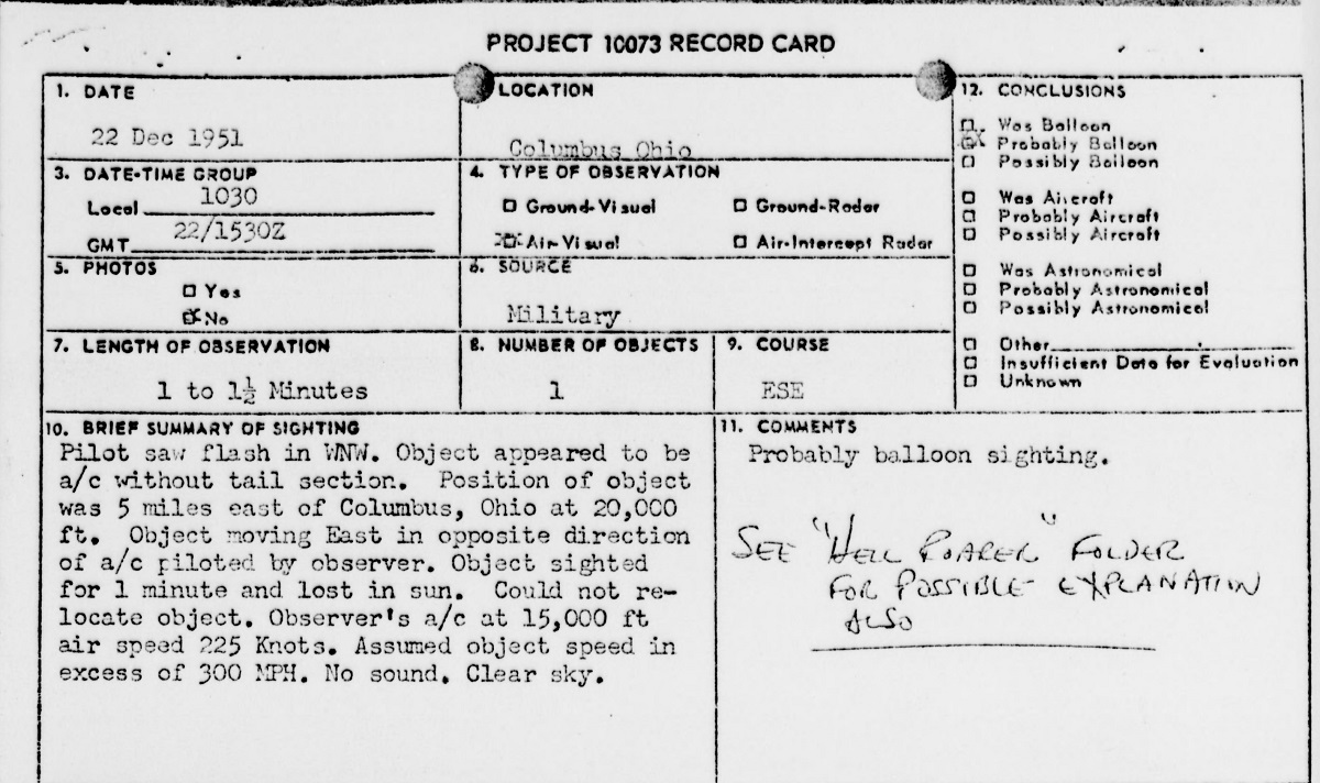
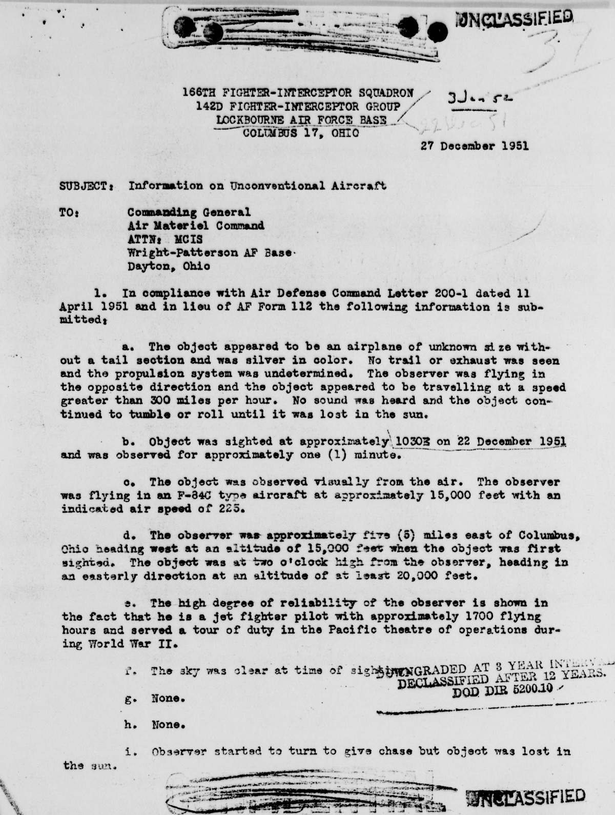
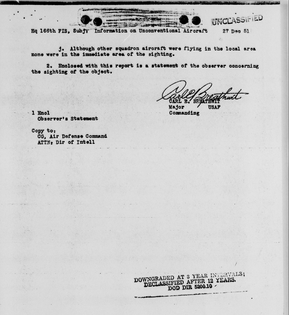
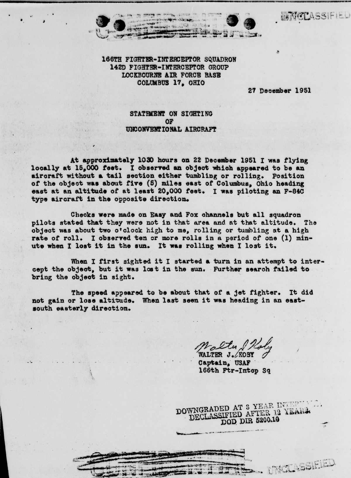
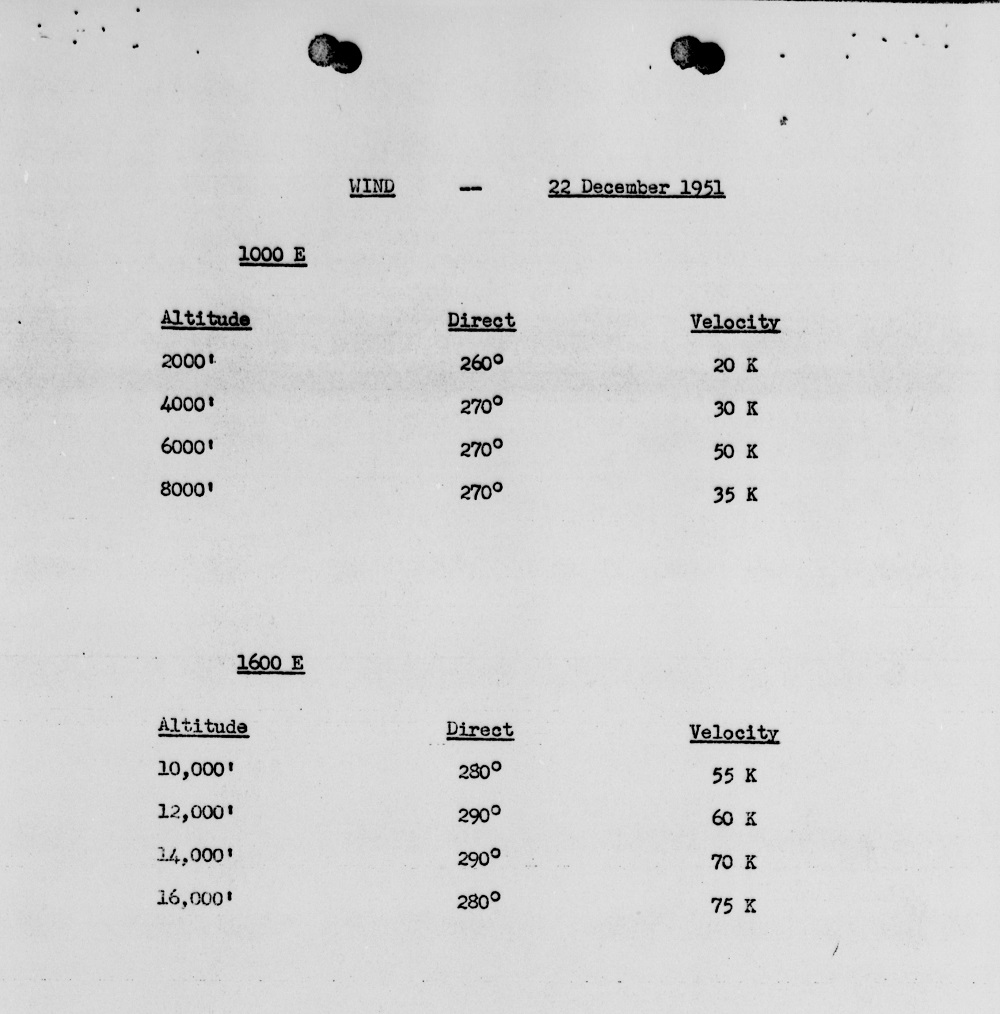
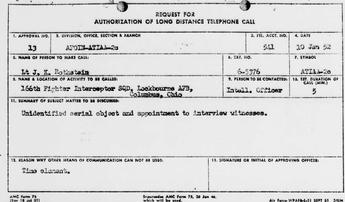
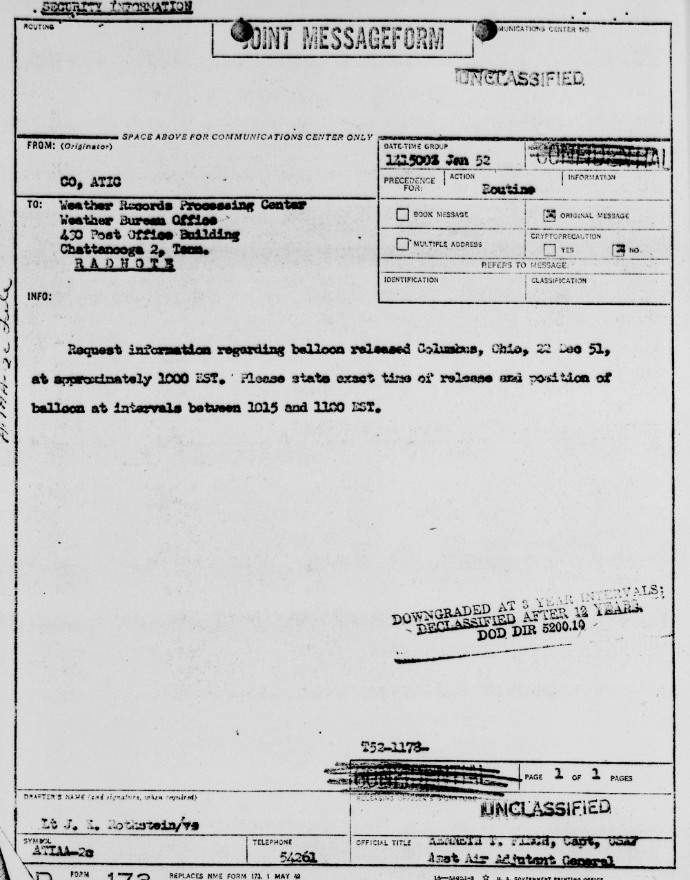
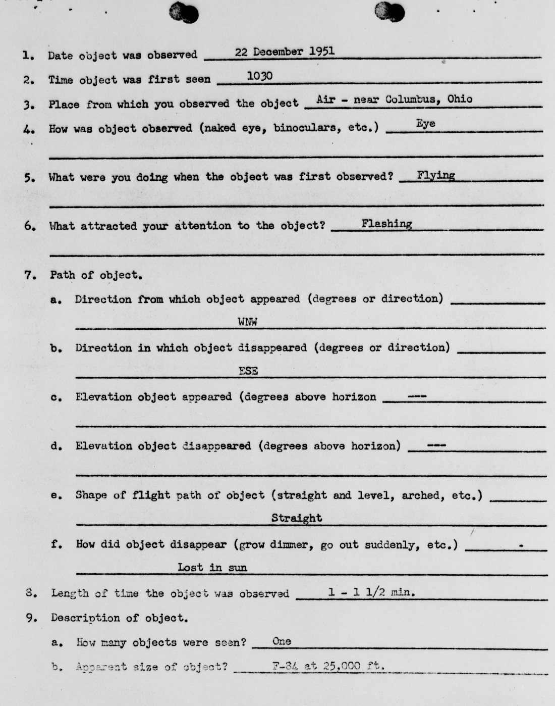
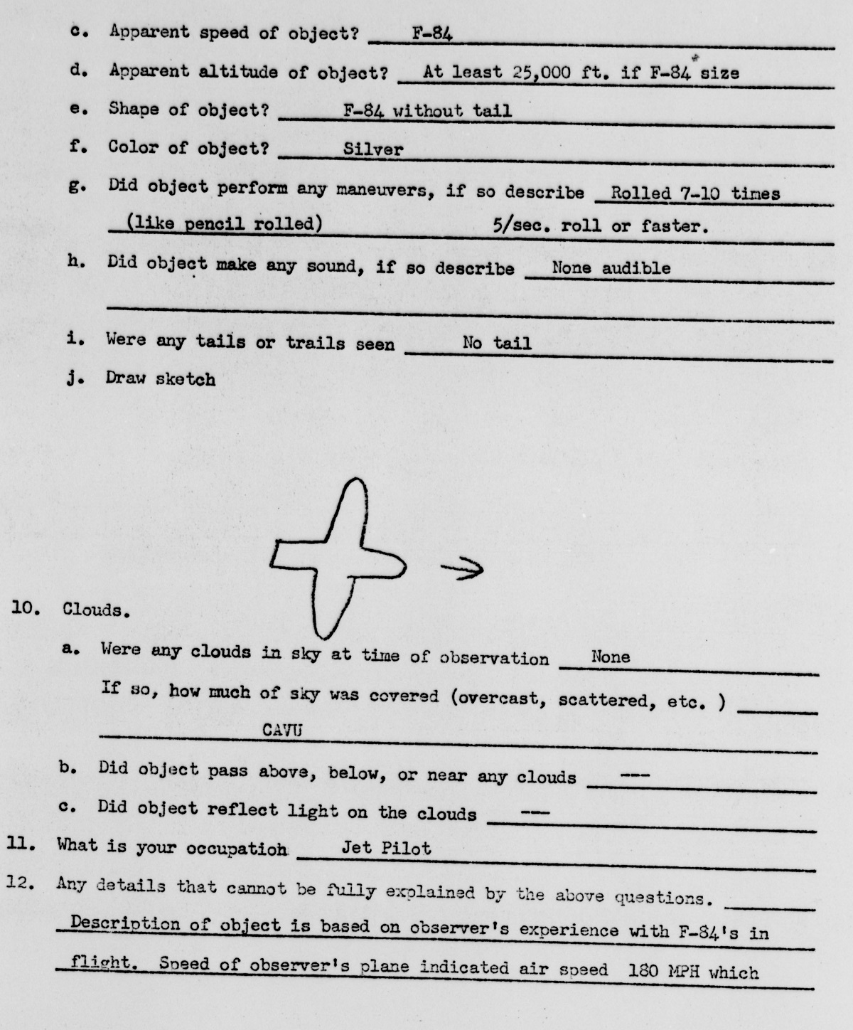
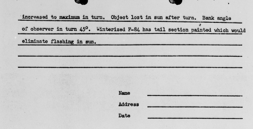
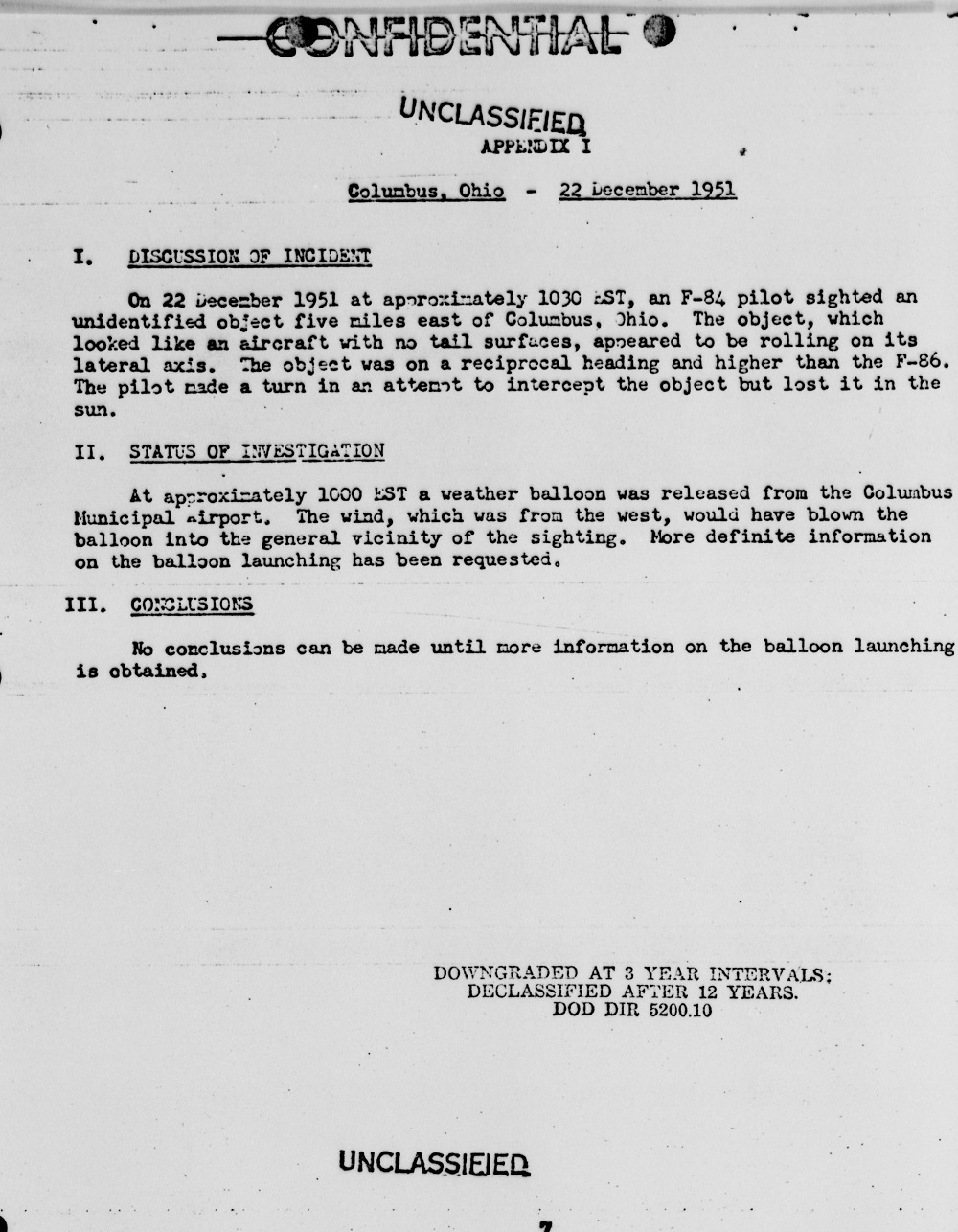
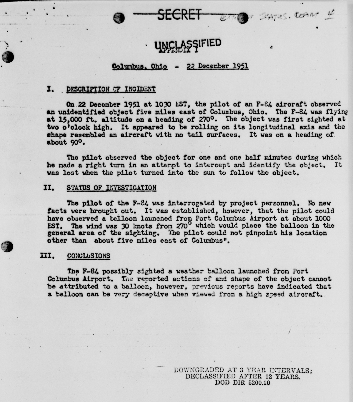
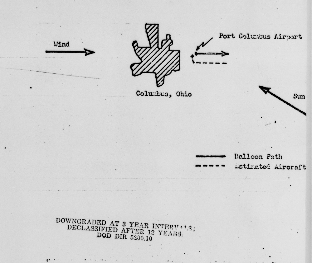
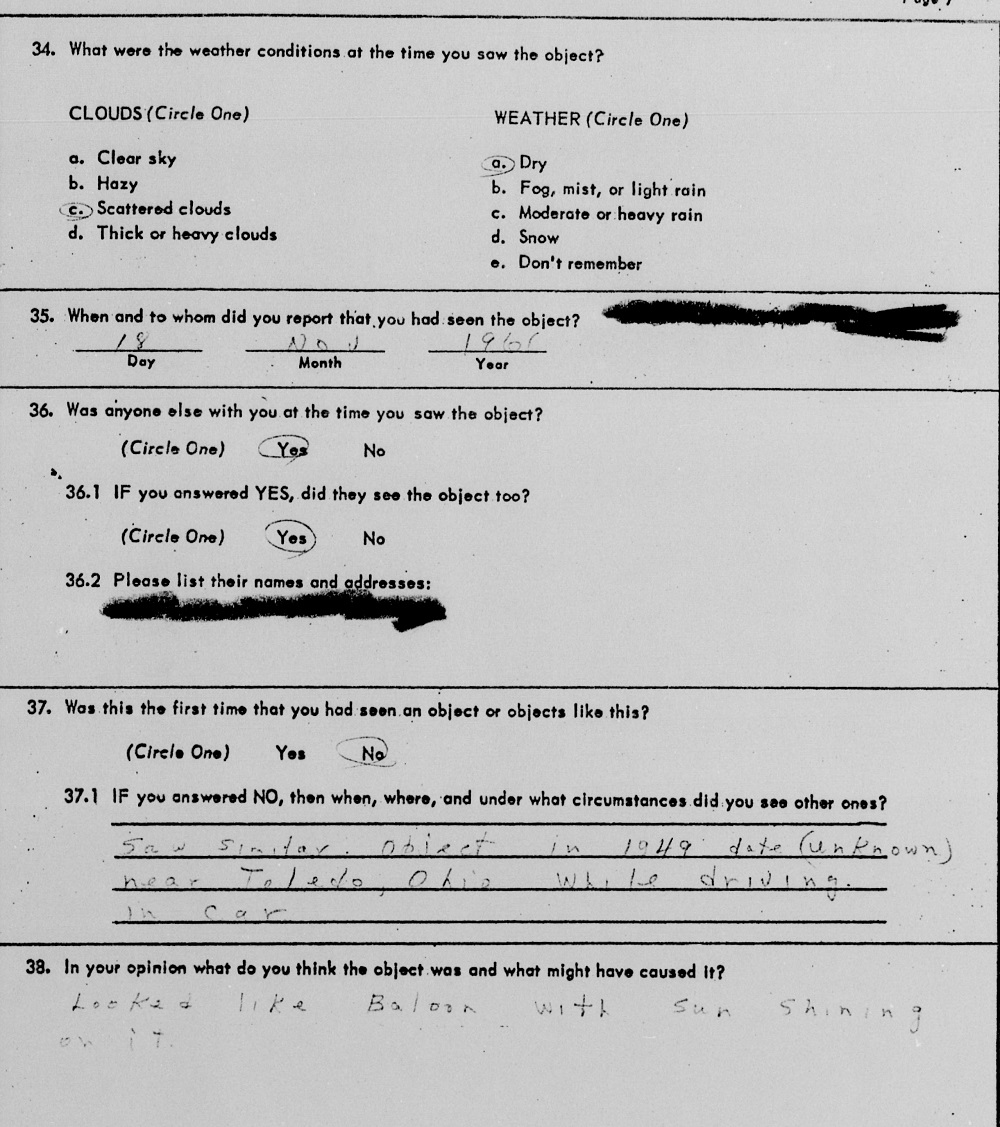
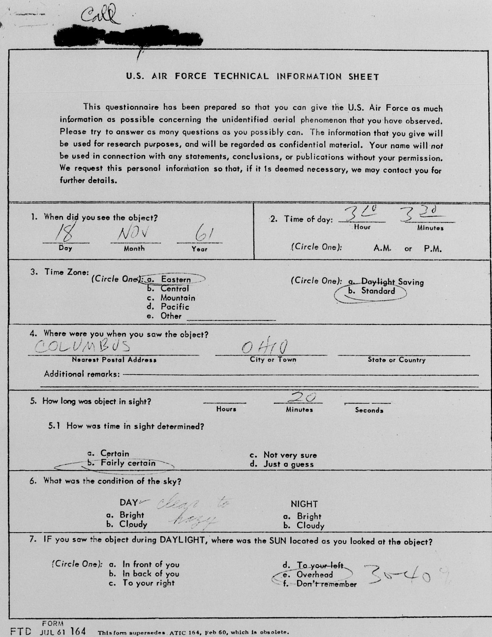
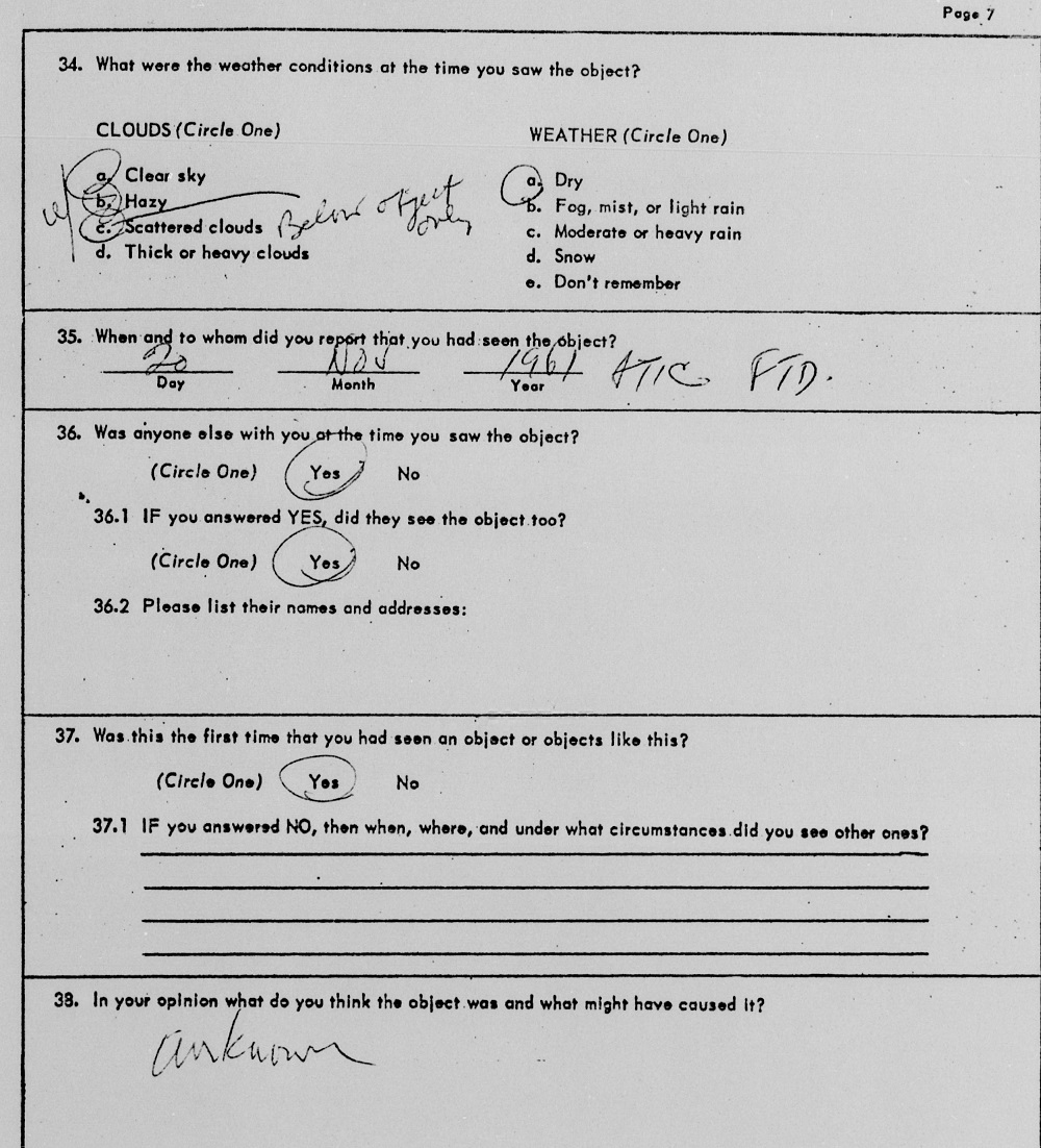
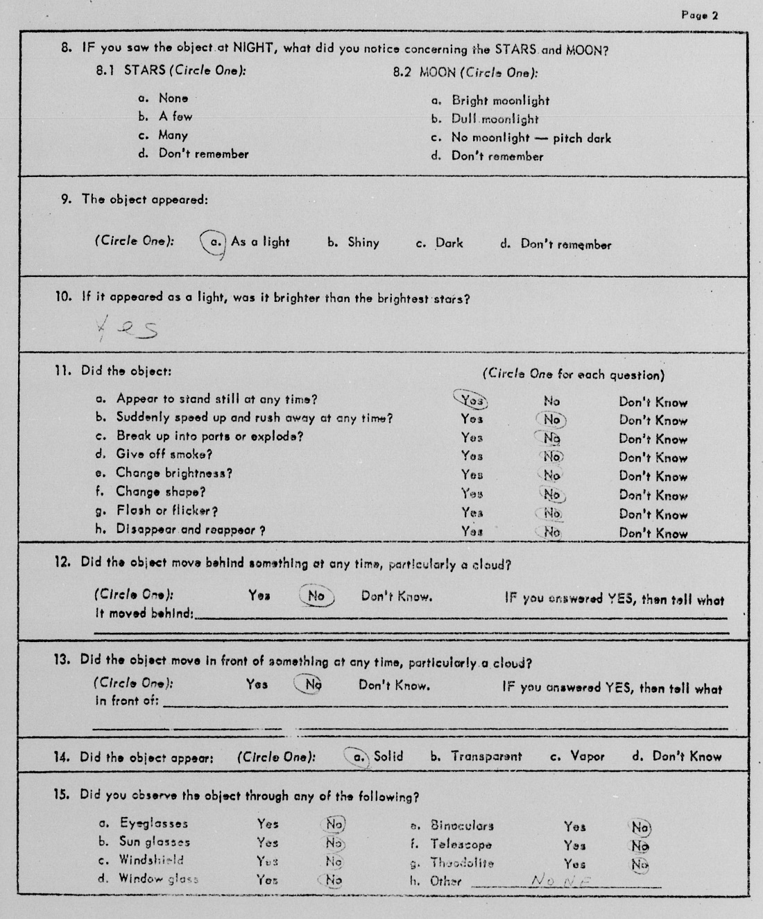
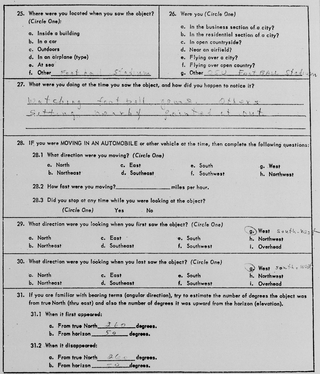
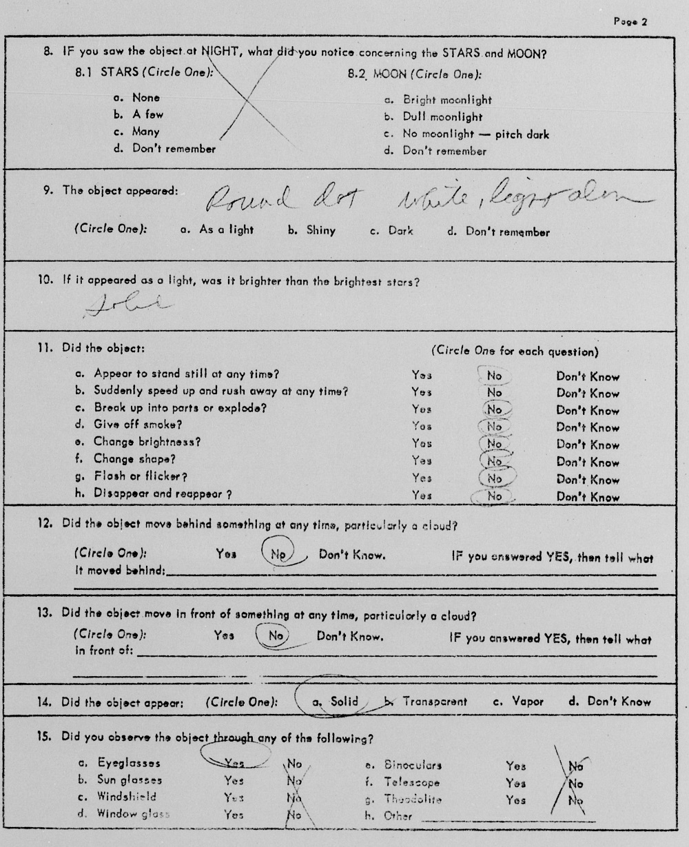
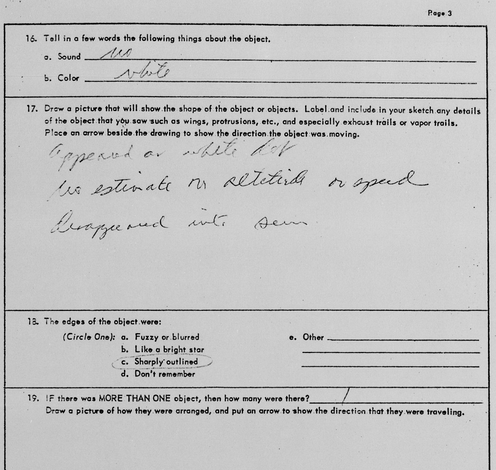
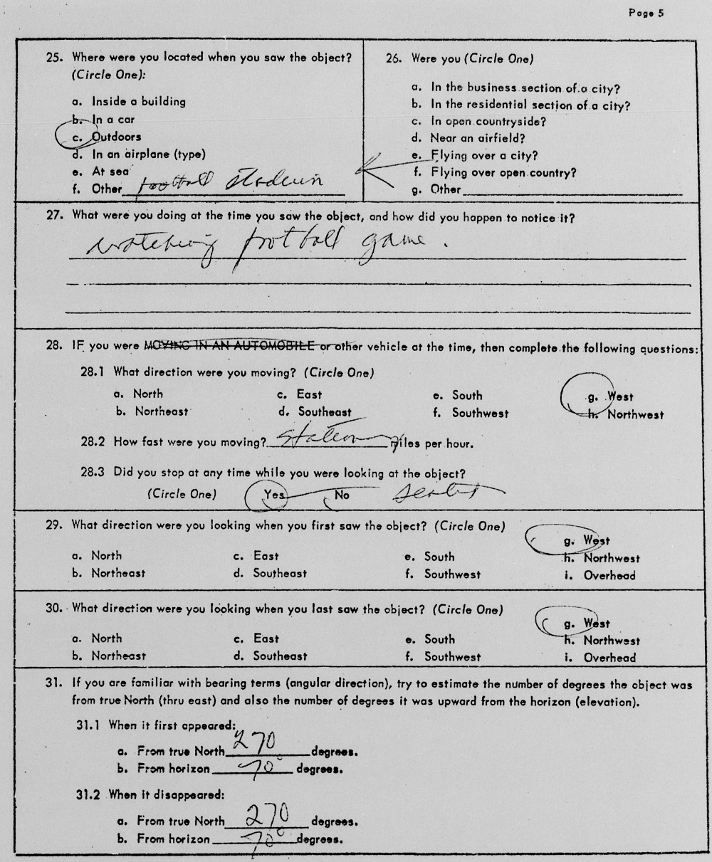
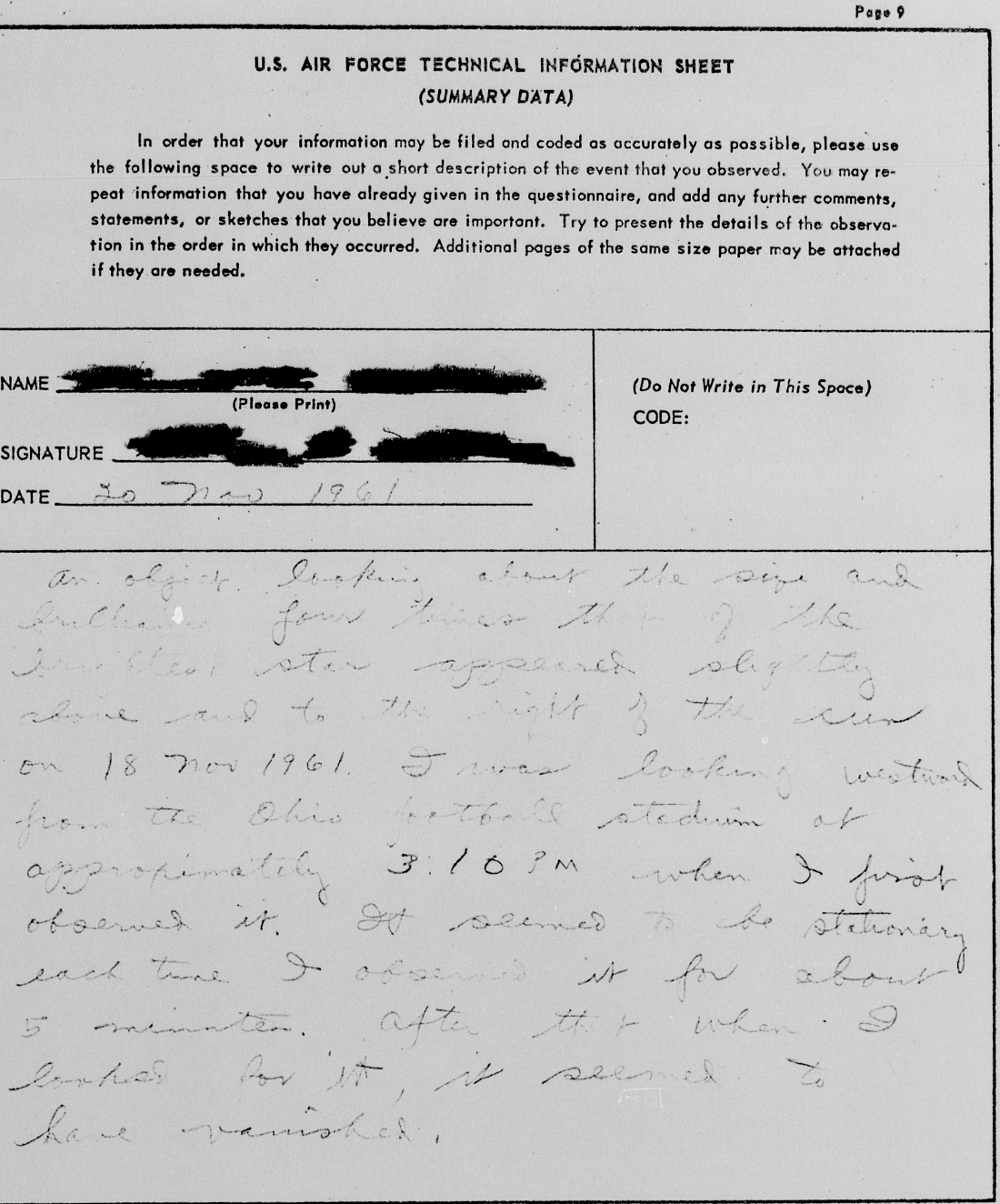
From the files of Project Blue Book. This incident occurred during an Ohio State home football game and could be viewed from the stadium. The object had multiple witnesses, whose accounts are in the pages below. The object was thought to be a balloon, but was never positively identified.


For more incidents around the world, visit the following links.
UFO Database
Mutual UFO Network
National UFO Reporting Center


Things Developers Say


On occasion, city leaders and developers say some absurd, ridiculous and hilariously tone-deaf comments regarding development and other urban issues in and around Columbus. And sometimes, as is the case with this example, those comments will highlight the often underwhelming results compared to the rhetoric.

15 years ago, the southeast corner of West Henderson and Reed Road was filled with a family-owned Italian restaurant called Da Vinci’s Ristorante. The restaurant had sat at the location since the mid-1970s and had become something of a local institution for the area.

For reasons that have been lost if ever reported, Da Vinci’s was closed and torn down in the spring of 2006. The family, it seems were either tired of the restaurant business, or had decided that a prominent location such as theirs could be a better money-making operation if it was redeveloped. Hence, Arlington Pointe, the current development on the site, came into being.

In a Dispatch article from that time, the developer- Ruscilli Real Estate Services- talked about the development in somewhat glowing terms.
“We wanted something that had more of a streetscape appeal,” said Ruscilli Real Estate President Tim Kelton. “There’s a lot of parking in the back and a hallway in the center. We wanted the shops and restaurants and everything very close to Henderson Road to fit into the neighborhood better.”

And what exactly did this development with lots of “streetscape appeal” look like? Yeah, it was just a standard strip center, the same kind that has been built 100,000x over across Ohio and the country, and now dominate the suburbs.
Things developers say Columbus, Ohio
Do the shops look close to Henderson? They are set well back from Henderson, actually, and a large parking lot wraps the entire way around the building. In fact, there is more parking fronting Reed and Henderson than there is in the lot behind the building, as can be seen from the aerial.

Like so many of these suburban strip centers, getting to the shops and office space by any means other than a car was completely ignored. In fact, the development caters to cars so thoroughly that it actually has its own mini-off ramp from Henderson.

Now, there are sidewalks around, but the chances that anyone actually uses them in what must be an unpleasant, loud and dangerous walk seem slim.

Ruscilli did get one thing correct, though- the project did fit in with the area given that the vast majority of neighboring development is much the same.

You can peruse the Proposed Development for upcoming projects.


Earliest First Snows in Columbus


Earliest first snows in Columbus

The city and area may have its first accumulating snow this evening into Sunday, according to the Wilmington National Weather Service. Some may think that it’s a bit early for this to be happening, but in fact, there have been many years with far earlier first snowfalls. So what exactly were the earliest first snows in Columbus?

The earliest recorded measurable snowfall in Columbus occurred on October 10, 1906. A strong cold front brought rain on the 9th that changed to snow showers during the early morning hours of the 10th. The snow only amounted to 0.1″, but it was enough to be counted as officially the earliest measurable snowfall on record.

Here are earliest days with snowfall of any amount.
1. 10/4/2014: Trace
2. 10/9/1979: Trace
3. 10/10/1906: 0.1″
4. 10/11/1906: Trace
5. 10/12/1907, 10/12/1909, 10/12/1917, 10/12/1921, 10/12/1988, 10/12/1991, 10/12/2006: Trace
6. 10/13/2006: Trace
7. 10/14/1937: Trace
8. 10/16/1943, 10/16/1978, 10/16/2004: Trace
9. 10/18/1966, 10/18/1972, 10/18/1992: Trace
10. 10/19/1917, 10/19/1925, 10/19/1972, 10/19/1974, 10/19/1989: Trace
10. 10/19/1880: 1.0″
10. 10/19/1989: 0.4″
11. 10/20/1889, 10/20/1974, 10/20/1989, 10/20/1992: Trace
12. 10/21/1913, 10/21/1976, 10/21/1987, 10/21/1989: Trace
13. 10/22/1904, 10/22/1913, 10/22/1917: Trace
13. 10/22/1925: 1.0″
14. 10/23/1962, 10/23/2006, 10/23/2013: Trace
14. 10/23/1917: 0.6″
15. 10/24/1929, 10/24/1937, 10/24/1955, 10/24/1962, 10/24/2006, 10/24/2013: Trace
16. 10/25/1892, 10/25/1926, 10/25/1967, 10/25/1980: Trace
16. 10/25/1962: 1.3″
17. 10/26/1926, 10/26/1942, 10/26/1957, 10/26/1962, 10/26/1980, 10/26/2001: Trace
18. 10/27/1886, 10/27/1898, 10/27/1957, 10/27/1976, 10/27/2008: Trace
19. 10/28/1939, 10/28/1952, 10/28/1967, 10/28/2008, 10/28/2017: Trace
19. 10/28/1906: 0.1″
19. 10/28/1910, 10/28/1925: 0.5″
20. 10/29/1890, 10/29/1893, 10/29/1925, 10/29/2002, 10/29/2012: Trace

So the first traces of snow have occurred nearly a full month and a half prior to today’s date. In 2014, the first trace of snow occurred just a few weeks after the end of summer!

And here are the earliest measurable snowfalls only.
1. 10/10/1906: 0.1″
2. 10/19/1880: 1.0″
2. 10/19/1989: 0.4″
3. 10/22/1925: 1.0″
4. 10/23/1917: 0.6″
5. 10/25/1962: 1.3″
6. 10/28/1906: 0.1″
6. 10/28/1910, 10/28/1925: 0.5″
7. 10/30/1925: 1.5″
7. 10/30/1993: 3.6″
7. 10/30/2012: 0.6″
8. 10/31/1954: 0.2″
8. 10/31/1993: 1.0″
9. 11/1/1951, 11/1/1954: 0.2″
10. 11/2/1951: 1.3″
10. 11/2/1954: 0.2″
10. 11/2/1966: 4.7″
10. 11/2/1999: 1.1″
11. 11/3/1954: 0.1″
11. 11/3/1966: 1.0″
11. 11/3/1999: 0.4″
12. 11/4/1926: 1.4″
12. 11/4/1936: 3.5″
12. 11/4/1954: 0.4″
12. 11/4/1997: 0.5″
13. 11/5/1897, 11/5/1967: 0.1″
13. 11/5/1966: 0.3″
13. 11/5/1992: 1.2″
14. 11/6/1886: 1.2″
14. 11/6/1951, 11/6/1967: 0.2″
14. 11/6/1971: 1.8″
14. 11/6/1988: 0.8″
14. 11/6/1993: 0.1″
15. 11/7/1894: 3.0″
15. 11/7/1953: 0.4″
15. 11/7/1967: 0.9″
15. 11/7/1991: 0.2″
16. 11/8/1900: 0.5″
16. 11/8/1927, 11/8/1933: 0.1″
17. 11/9/1892: 2.1″
17. 11/9/1913: 5.0″
17. 11/9/1941, 11/9/1968: 0.3″
17. 11/9/1971: 0.7″
17. 11/9/1996: 0.2″
18. 11/10/1892: 1.5″
18. 11/10/1894: 0.3″
18. 11/10/1913: 2.5″
18. 11/10/1921: 0.5″
19. 11/11/1894, 11/11/1983: 0.5″
19. 11/11/1921, 11/11/2013: 0.3″
19. 11/11/1986: 0.4″
19. 11/11/1995: 0.1″
19. 11/11/2019: 2.1″
20. 11/12/1886: 2.2″
20. 11/12/1911: 0.2″
20. 11/12/1921: 0.5″
20. 11/12/1968: 0.4″
20. 11/12/1991: 0.3″
20. 11/12/2013: 0.9″
20. 11/12/2019: 0.7″

The average first snow in Columbus is typically between the 2nd and 3rd week of November, so really, this year’s first snow is arriving more or less right on schedule. Accumulations are predicted to be 1″ or less. Historic climatology records are available for all periods.