Columbus Christmases Past Photos


These Columbus Christmases past photos give a short walk down memory lane of one of the most popular and favorite holidays.

Date: 1952
Location: Corner of W. Town Street and S. Ludlow Street along the Scioto River.
Columbus Christmases Past Photos
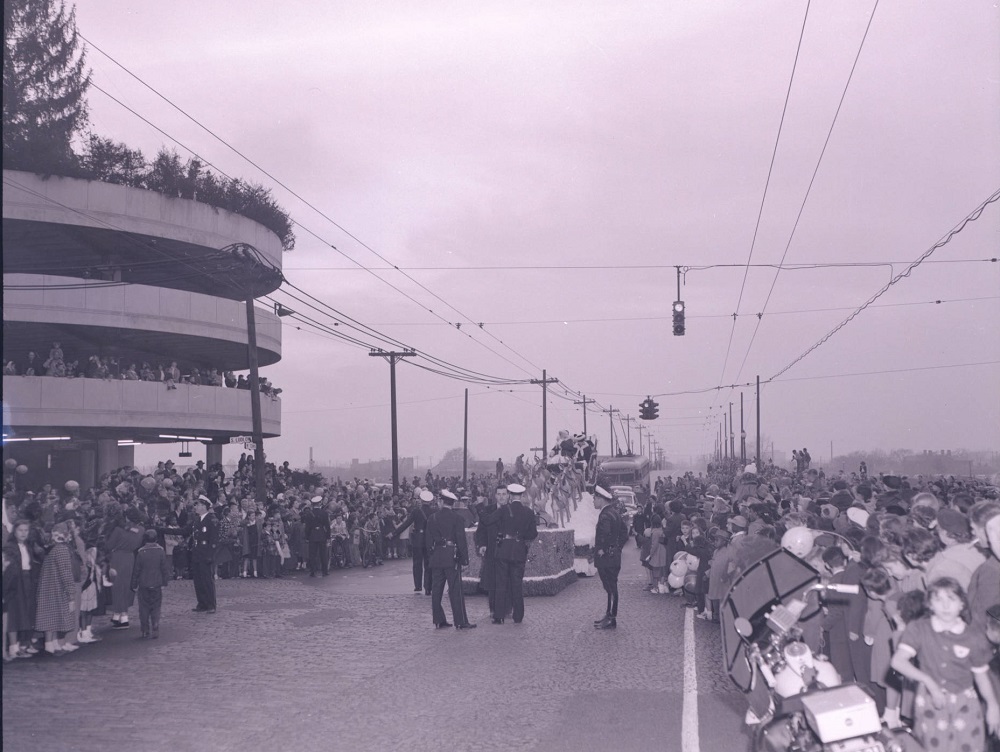
Santa and Mrs. Claus ride on a float in the annual Lazarus Christmas parade.

Date: 1980
Location: Ohio Expo Center Multipurpose Building at 717 E. 17th Avenue.

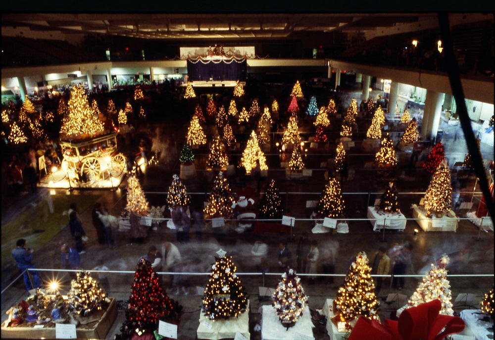
The Festival of Trees was an annual event sponsored by Children’s Hospital and Nationwide for charities. In 1980, there were 82 themed Christmas trees on display, which people could buy for at prices up to $1,000 each.

Date: Christmas Day, 1983
Location: Corner of Ebner and Columbus Street, German Village

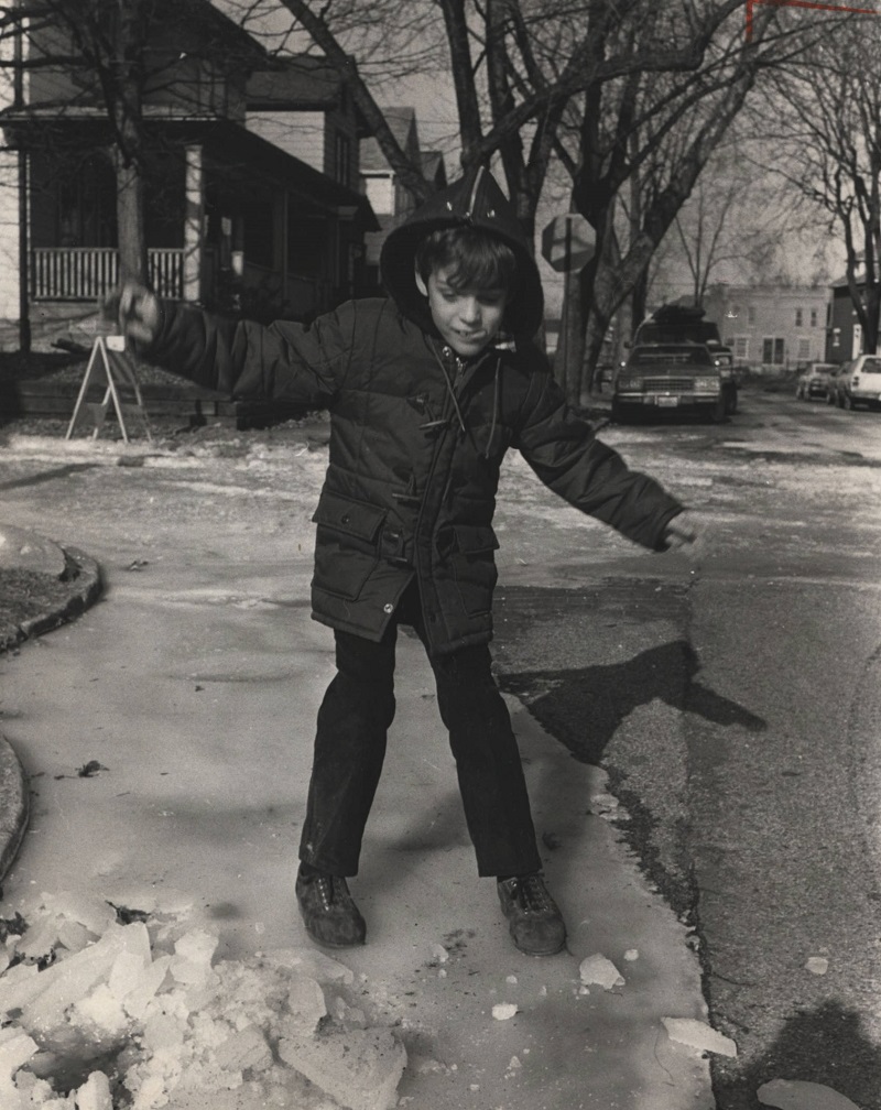
Christmas 1983 was one of the coldest on record, with a high of just 1 degree above zero and an average temperature of -6. The cold caused water mains to burst in several locations, including in German Village, which some children took advantage of for a little fun.

Date: 1965
Location: 518 E. Broad Street

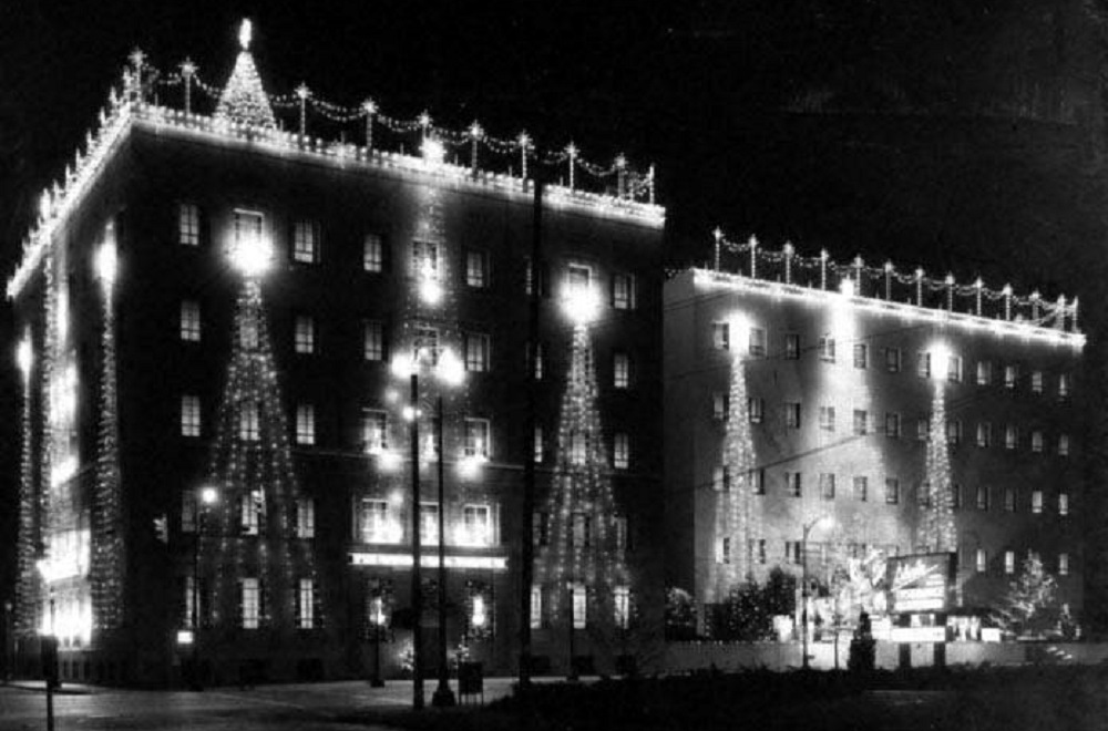
State Auto Mutual Insurance began holding a Christmas lighting event every year beginning in 1931.

Date: Around 1955
Location: Lazarus Department Store, South High Street

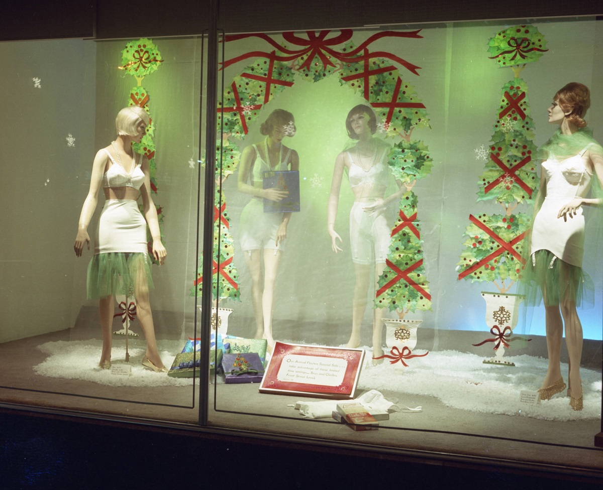
Lazarus was famous for its window Christmas displays for well over 100 years, with many being very elaborate. The Christmas displays continued until the 2000s.

Date: 1992
Location: Scioto Riverfront, Downtown

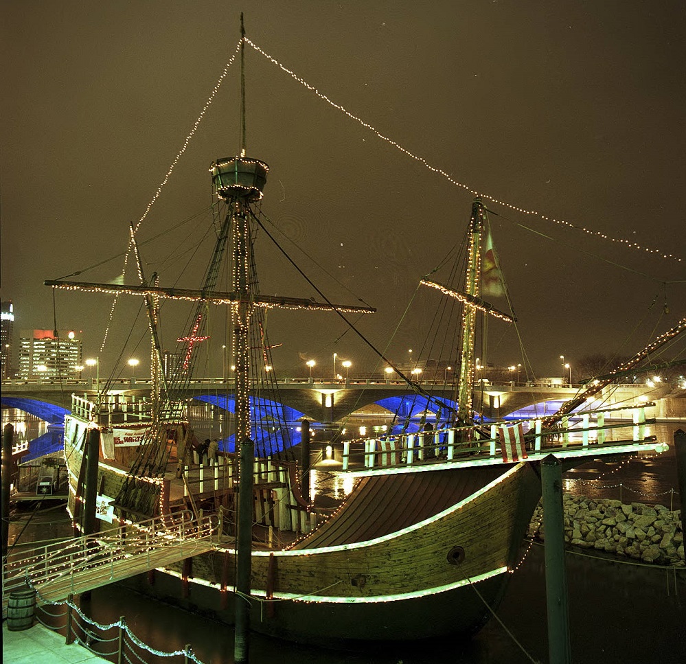
The replica of Christopher Columbus’ Santa Maria, decorated for Christmas in the photo, sat in Battelle Riverfront Park from 1991 until it was permanently dismantled during construction of Scioto Greenways in 2014.


Historic Buildings in Imminent Danger of Demolition

Columbus, like many cities, has a decidedly mixed history with historic preservation. It has lost so much, and it continues to lose more with every passing year. The Columbus Landmarks Foundation puts out of list every year of Columbus’ most endangered historic buildings in imminent danger of demolition. Here is 2019’s list. Not all of the threatened old buildings in Columbus get attention. Here are a few more that are likely to meet the wrecking ball relatively soon.

Highland and 11th Block
1619 Highland Street
Built: 1905
Ohio State recently purchased this building after reportedly trying to buy it for decades. The university now owns the entire block that this building sits on, and the plans are for eventual redevelopment within a few years. What might replace it is not yet known.

historic buildings in imminent danger

1619 Highland in 2019.

141 W. 11th Avenue
Built: 1890s
If OSU decides to redevelop the entire block, and that seems to be the plan, another historic building near 1619 Highland could also be lost. The German House is the last remaining original home this far west on 11th Avenue in what was once a historic neighborhood. OSU has systematically demolished almost all of the other homes along 11th Avenue, beginning in the 1950s. While there are no announced plans for its demolition, news of the block’s redevelopment seem to predict this old home’s doom.

The German House in 2015.

King and High Block
1343-1347 N. High Street
Built: Around 1920

1343-1347 North High in 2017.

1355-1359 N. High Street
Built: Around 1890

1355-1359 N. High Street in 2015.

Both of these High Street properties, directly across the street from the Weinland Park Kroger, are under threat from a proposed redevelopment plan. Originally, the developer had proposed an 11-story, mixed-use building for this block with the intention of incorporating both of the old buildings into the plan. However, it seems that they became frustrated with the approvals process, and so, in seemingly a total spite move, greatly reduced the size of the project as well as any intention of saving the old buildings. The out-of-state developer’s new design doesn’t require any variances, and so it seems like the final product is out of the hands of the local neighborhood commission and city, unfortunately. What could’ve been a great project is now essentially a middle finger from the developer and arguably one of the worst-designed proposals in recent years.


Weekly Update 5/27-6/2


On April 22nd of this year, All Columbus Data suffered a major hack. Several attempts were made to restore the website in full and to save the content through backups. At least twice, the site was restored only for it to fall back into the hacked configuration- some kind of jewelry website. Eventually, it was determined that there was corruption within the core files themselves, and since it could not be safely determined which ones, the host refused to restore any of the original content, as the attack was malicious enough to threaten the hosting servers themselves. So, the site was completely scrubbed and at least some of the original content that was not otherwise saved on archived websites was lost. After 7 years of work, it was a sickening result. Now, the rebuilding process has begun.
Fortunately, a lot of the core lost data much of the site was built upon still existed in my own personal files, so for many of the pages, it’s simply a matter of putting that information back up on new pages. That is what I’ve been working on this week. Here is what I’ve done so far this week:

-2 new articles were added.
-Monthly weather pages for April and May have been restored, complete with updated data for 2019.
-Several pages within the Historic Building Database have had at least a few buildings added.
-Partially restored the Completed page for Columbus Development .
-Added several population graphs to the Columbus city, county and metro area demographics pages.
-Partially restored- and expanded- the Columbus Tornado History page, one of All Columbus Data’s most popular.

I will continue to work to restore more pages and posts over time, but it will be an extended process.

How I Would Redevelop the Westland Mall Site


Westland mall site

The desolate view of the former Westland Mall.

Next up on the easy reposts is this Google Map I made on how I would redevelop the Westland Mall site. It was recently announced that Westland Mall will very likely be torn down sometime later this year, but the current owners have not yet given any details on a potential redevelopment plan. Here is the article about Westland’s imminent doom.

What I would like to see go into this huge site is a new neighborhood that employs a lot of urban-style characteristics. That means low to mid-rise mixed-use buildings that surround a large urban park. The buildings would contain ground floor retail with residential above. Offices, markets and hotel space would also be included in the new neighborhood. The buildings would front both West Broad and Georgesville Road. New multi-use paths would connect this development to existing paths on Georgesville and to the miles-long Camp Chase Trail along the railroad tracks near Sullivant and Georgesville. The main central park would have playground space, a ball field or two, and perhaps even a small pond. Bike lanes would go throughout, along with wide sidewalks for potential restaurant and retail patio space. Basically, this would be like the West Side’s version of the Bridge Park development in Dublin. Read more about that project here.
This would end up being a hugely transformative project for the West Side in a way that the new casino never could be. I suspect, however, that the developer will go with some kind of single-story, single-use big box retail concept like a Walmart, along with fast food outlets near West Broad. Hopefully, that is not the case and they are more forward thinking.

So here is the map I made on the general idea of what I think should happen:

Columbus Historic Buildings Mapped on Google


Columbus Historic Buildings Map

This link is continuously being updated because there are thousands and thousands of historic buildings in the Columbus area. I am focusing on just those within I-270. Information includes the address or name of the building, the year or approximate time built, height in stories, original and current uses, as well as whether or not it is on the National Register of Historic Buildings. If so, I included the year that it was added to the Register.

The buildings on the map go all the way back to 1804 and run through 1925.

Because this map is a work in progress, the link will be permanent under the City Resources links on the home page. Keep checking back to see more places being added over time.

Enjoy!