I have been wanting to do these maps for awhile now, as there have been several searches on the site for them and they weren’t available. It took a lot of work, but here are the maps for Columbus area murders by zip code 2008-2015.
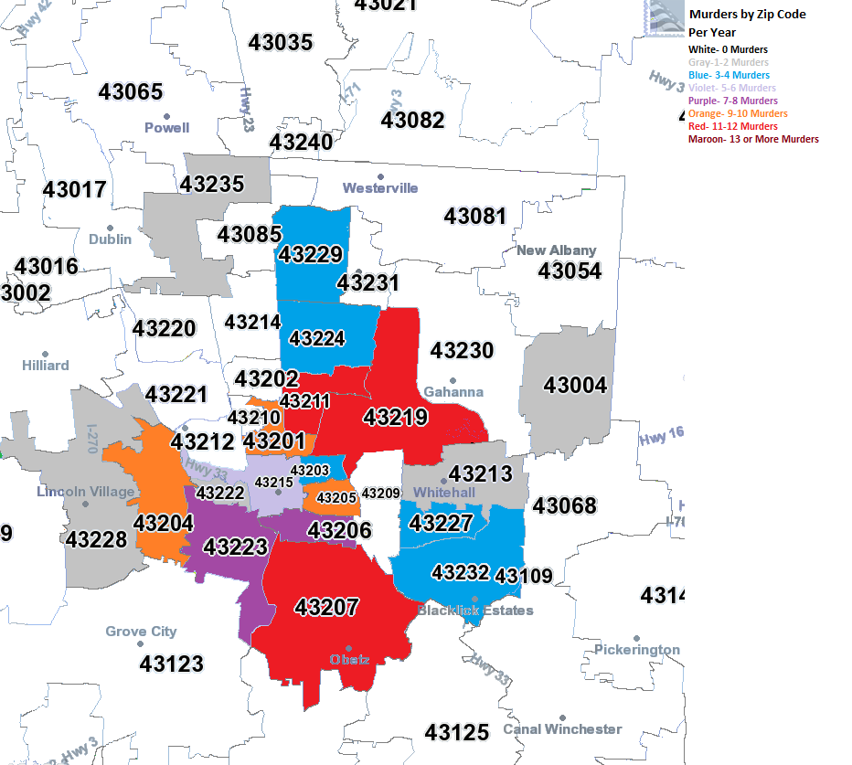
2008 In 2008, almost all murders were contained within the I-270 boundaries. The East and South Sides were the worst areas.
2009 In 2009, there began to be a bit of diffusion on where murder was taking place. While parts of the urban core remained the worst areas, suburban areas also saw the occasional murder.
2010 The diffusion continued in 2010.
2011 And in 2011.
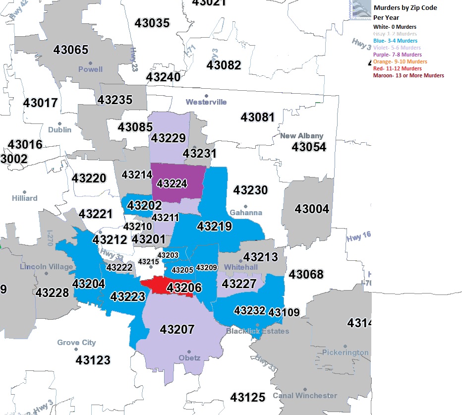
2012 2012 was the most diffuse of all the years, with no heavily concentrated areas, even in the urban core as much. Meanwhile, most of the suburban zip codes within Franklin County saw at least 1 murder.
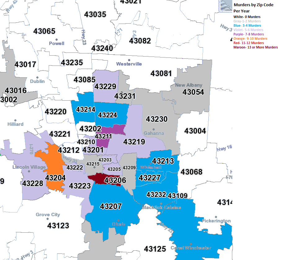
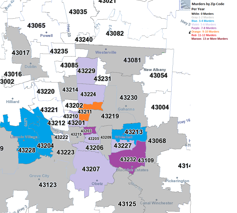
2013
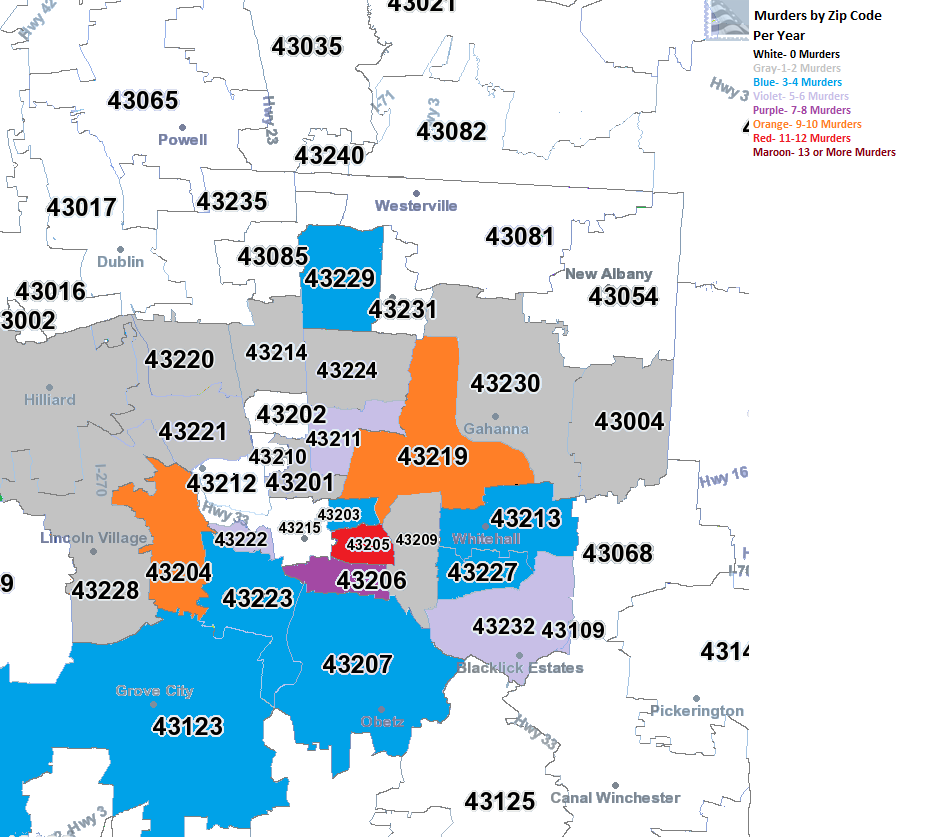
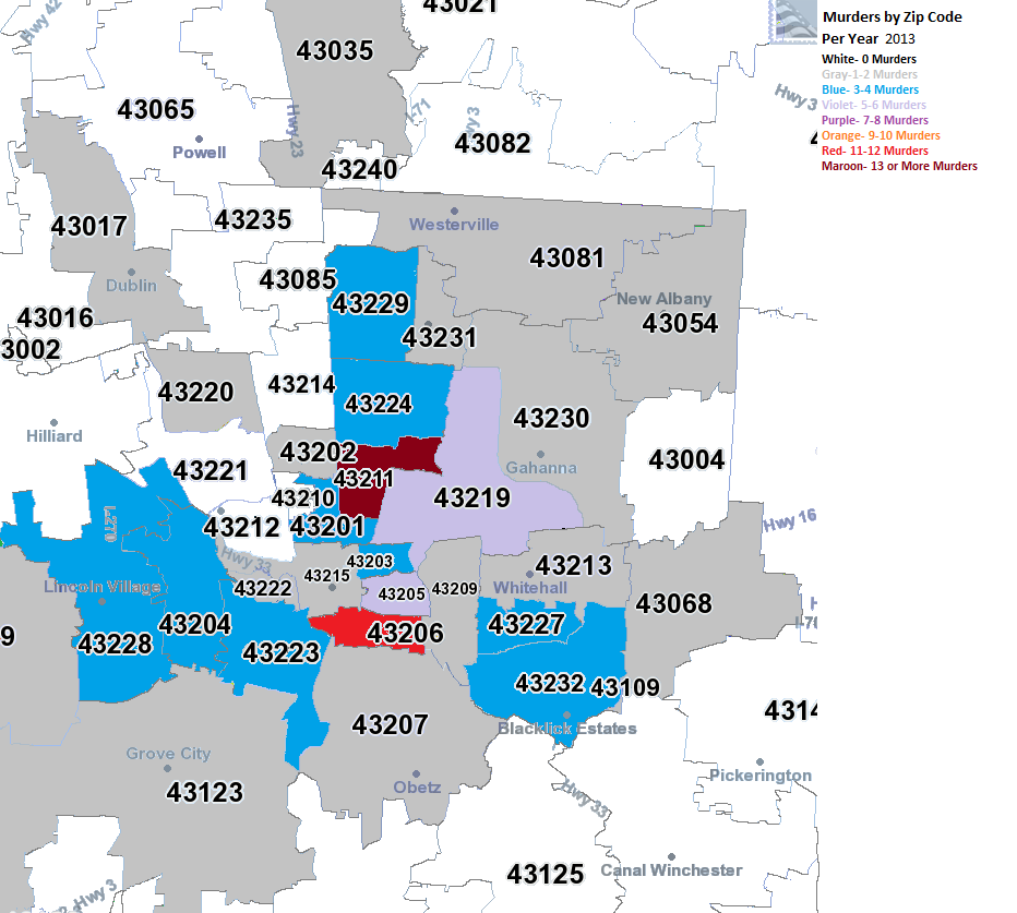
2014
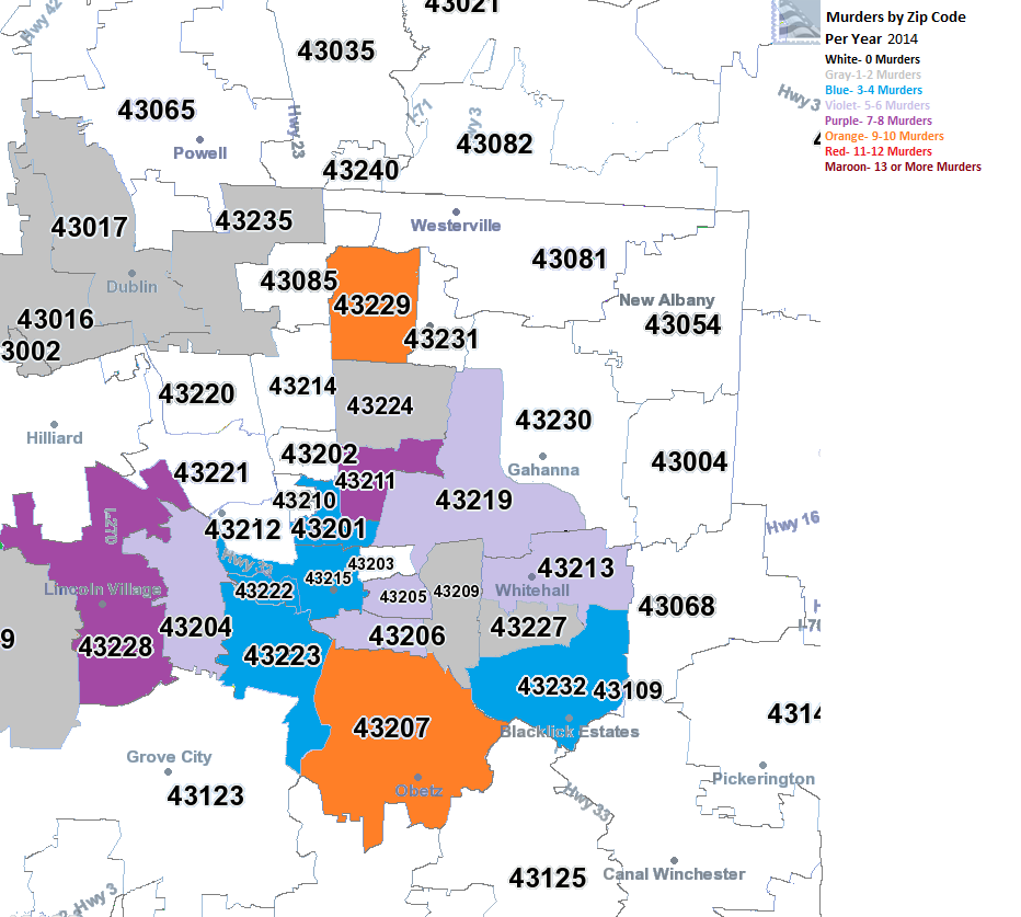
2015 By 2015, most activity was on the eastern side of the city, particular South Linden and the Far East Side around Whitehall and Reynoldsburg, but all areas along the 270 area on the Far East Side had the highest levels of murder in the county. The central core generally stayed a lot lower, creating a much more prominent donut shape than what existed back in 2008. This seems to indicate that as the central core gains in population and income, crime is also being pushed further out.
After a generally cold December, the January 1879 arctic outbreak would begin the new year, leading to Columbus’ 2nd coldest temperature ever officially recorded. The outbreak began on January 2nd, when a strong cold front moved in from the northwest in the early afternoon hours. The temperature fell rapidly during the evening, reaching a low of -13 on the 2nd for a total drop that day of 42 degrees. The core of the cold air moved across Ohio during the day of the 3rd, so temperatures warmed very little. Highs across the state were in the single digits south to below zero across the norther 2/3rds. Columbus had a rare below zero high of -4, which is the 2nd coldest January high on record and the 3rd coldest high of any month. The low on the 3rd was a frigid -20. This low stood as the coldest temperature in Columbus for 115 years, only being surpassed during the great arctic outbreak of January 1994, during which the temperature fell to -22.
The strong front was very moisture starved, and only a few tenths to an inch to an inch of snow fell with its passage.
Temperatures remained in the single digits for two more days before a gradual warming commenced. By the 8th temperatures went above freezing. The rest of January 1879 was fairly tame. 16 days after the 8th had highs of 35 or greater.
Of note is that the temperature of -20 occurred two more times before the end of the 19th century, in January 1884 and February 1899.
A severe 1913 hailstorm hit parts of the South Side on that Wednesday afternoon. In an issue of The Democratic Banner out of Mt. Vernon, the headline on July 11th read “Streets Covered with Ice Boulders: Destruction Wrought by Hail Storm at Columbus.”
The article went on: This city was visited by probably the most disastrous hailstorm in its history. The damage to crops and buildings in this immediate vicinity is estimated conservatively at $125,000. (About $3.1 million today). South Side florists alone report losses of approximately $50,000. In hundreds of houses practically every window was broken. The ground on the South Side was covered by a thick layer of “ice boulders” for an hour or two afterwards. As a midsummer phenomenon it probably was without a parallel in this state.
Accompanied by 45 mph winds, the hail that fell was reported to be about 3″ in diameter. The hail was large enough to hit and fracture the wrist of J.W. Sprouse, a teamster, and shattered glass from a greenhouse was driven through the arm of William Bernard, a florist.
The Before and After July 2014 edition shows a few famous Downtown buildings and what ultimately happened to them.
The Hippodrome Theater Operated from October 26th, 1914 to December 31st, 1933. Address: 77 N. High Street, Downtown Seats: 300+ First movie shown: “The Nightingale” with Ethel Barrymore Last movie shown: Unknown Opening Admission: 10 cents
Photo of the entrance to the Hippodrome Theater, 1915.
The silent-era Hippodrome Theater was developed by G.E. Overton, who took over the Bonnett Jewelry store that occupied the building previously. News articles at the time of its opening described the décor in this way:
The little theater, which seats over 300, is neatly decorated in yellow. The lobby is attractive in white marble and the foyer is in yellow and gold. There is no stage; the picture being projected against a large screen as in most picture theaters.
The Hipp, as it was referred by, had a 6-piece orchestra under the direction of W.H. Claspill. It was the first movie theater in Columbus to have an orchestra.
There seems to be a bit of confusion on just when this theater opened. The official first movie shown there was in 1914, but by some accounts, the theater actually opened in April, 1910. Also, there is some mystery on the lone photograph above. Some list it as having been originally taken in 1915, but others have it listed from 1934, after the theater had closed.
The Park Theater Operated until November 24, 1893. The date it opened is unknown. Address: 217 N. High Street, Downtown Seats: Unknown
The Park Theater began operations sometime in the 1880s or very early 1890s, and may have operated long after 1893 if not for a disaster from the building just to its south, the Chittenden Hotel. In 1889, Henry Chittenden purchased the office building of the B&O Railroad, added 2 floors and spent $400,000 (an enormous sum at the time) converting and renovating the building into a luxury hotel. In 1890, a fire broke out and gutted the entire building, but spared neighboring businesses like the Park Theater.
The second Chittenden Hotel. The Park Theater building can be seen on the very right. The photo is from 1892.
Chittenden decided to rebuild, and the 2nd Chittenden Hotel was completed in 1892. This second hotel had its own theater, the Henrietta, which was still partially under construction on November 24th, 1893. That evening at around 8pm, a fire started during a performance there. The fire originated in the auditorium, in an area that was still under construction and spread into the seating area itself. Once the flames breached the theater, strong winds quickly spread the fire and began to burn the hotel as well as surrounding buildings, including the one that housed the Park Theater. By the time the fire burned itself out just the next morning, both theaters, the hotel, a drug store, saloon, shoe house and clothing shop were all completely destroyed.
The second Chittenden and Park Theater, November 1893.
The Park Theater, November 25th, 1893.
Improbably, despite 2 hotels in the same locating burning down, Chittenden rebuilt for yet a 3rd time, with the largest and grandest version of all- not to mention with far better fire-resistant construction. The third time, it seems, was the charm, and the hotel survived from its completion in 1895 to its final demolition in 1973.
The unlucky Park Theater itself never rebuilt, though the lot had a new commercial building in its spot by 1895. That building also faced the wrecking ball in 1973.
The current location of where the Chittenden and Park Theater once stood.
For a good portion of the US, the winter of 2013-2014 was one of the worst, if not the worst, in recent memory. Cold and snow hit early in the season and didn’t let up until the first half of March. Now that April is behind us (the last month that snow typically might fall during a season), we can take a look back at the Winter 2013-2014 Review.
A Look Back at Snowfall For many in Central Ohio, winter provided its first taste on October 23rd, when a cold front briefly changed rain to a wet snow that coated car tops. This was merely a prelude to what would come.
2013-14 Winter Snowfall vs. Normal
November Notable Snow Events November 11-12th, 2013: This was the first real accumulating snowfall of the season, dropping a general 1″-2″ across the area. The highest total in Franklin County was 2″ reported just southeast of Clintonville. A map of the event can be found here.
November 26th-27th, 2013: The months 2nd and larger event occurred towards the end of the month, and dropped 1″-4″ across the county, with the higher totals on the east side of Columbus. A map of the event can be found here. The November total of 4.7″, while not anywhere near record breaking, was a top 20 snowiest, coming in at #14. November 2013 was also the snowiest Columbus had seen since 1972, when 6.3″ fell.
December Notable Snow Events December 6th, 2013: This was the first major event of the season. A low pressure center brought rain to the area on the 5th. As temperatures cooled, rain gradually changed to freezing rain and then heavy snow, dropping 3″-6″ across the area. A map of this event can be found here.
December 10th, 2013: The second event of the month was a persistent band of snow that set up alon I-71. The cold air produced high ratios, dropping 1″-3″. http://www.erh.noaa.gov/iln/events/20131210/
December 14th, 2013: Rain changed to snow along and north of I-71. http://www.erh.noaa.gov/iln/events/20131214/ December’s 12.7″ total was 2 1/2x normal, and the first 10 days of the month were the snowiest on record. It also made the month the 8th snowiest December on record. Further, it was the 2nd consecutive above average December and the 5th since 2007 to be so.
January Notable Snow Events January 2nd, 2014: The new year started off as snowy as the previous ended, when a low pressure brought occasionally heavy snow and 3″-5″ across the city. http://www.erh.noaa.gov/iln/events/20140102/
January 25th-26th, 2014: The months’ signature event, a strong storm brough a mixed bag of precipitation, including heavy snow to parts of the city. As the storm passed, additional snow squalls developed into the 26th and brought occasional whiteout conditions. Columbus’ official 2-day total was 8.3″. A map of the event can be found here, though it only lists totals for the 25th:
All told, the 17.7″ of snow for the month was the 16th snowiest on record, and the 8.3″ snow event tied for the 10th largest January event since records began.
February Notable Snow Events February 4th-5th, 2014: A low pressure brought heavy snow and mixed precipitation to the area, and proved to be winter’s largest snow event with 6″-10″ across the city. The 10.6″ at Columbus was the largest storm of the winter, tied as the 3rd largest February snowstorm, and provided the 7th largest daily February snowfall. http://www.erh.noaa.gov/iln/events/20140205/
February 14th-15th, 2014: Valentines Day brought a storm that skimmed the area with 2″-4″, with much higher totals to the south. http://www.erh.noaa.gov/iln/events/20140215/ February’s 15.9″ of snow was the 6th snowiest on record.
March did not break any records or have any large events, but it was more or less a capping month to a winter that kept snowing.
April saw just one snow event, on the 15th, when half an inch to 1″ fell, ending the snowfall season.
So ultimately, 2013-2014’s 56.4″ of snow ranks it as the 3rd snowiest winter since records began in 1878. It was also the #1 snowiest meteorological winter (December-February) on record. The graph below shows the top 10 snowiest winters. Notice that 4 of the 10 have occurred since 2002, with 3 since 2007. Are we possibly entering a snowier period? That remains to be seen.