2020 Election Results for Columbus Metro Counties


2020 election results

Although Ohio is technically still counting some votes, there shouldn’t be any significant movement in the overall numbers, so we can now take a look at how the local area voted down to the precinct level. In this post, though, the focus is on 2020 election results for Columbus metro counties, as well as past elections going back to 2000.

First, here are the voting total breakdowns by every metro county since 2000.

Delaware County
Total Votes By Election
2020: 126,374
2016: 105,639
2012: 98,899
2008: 92,581
2004: 80,456
2000: 55,403
Fairfield County
2020: 81,598
2016: 73,554
2012: 72,220
2008: 72,147
2004: 67,882
2000: 54,094
Franklin County
2020: 632,532
2016: 587,524
2012: 572,188
2008: 561,763
2004: 525,827
2000: 414,074
Hocking County
2020: 13,860
2016: 12,929
2012: 12,768
2008: 13,016
2004: 13,199
2000: 10,756
Licking County
2020: 94,396
2016: 83,624
2012: 81,550
2008: 82,570
2004: 79,420
2000: 62,466
Madison County
2020: 19,887
2016: 17,421
2012: 17,557
2008: 17,510
2004: 17,398
2000: 14,667
Morrow County
2020: 18,468
2016: 16,688
2012: 16,217
2008: 16,679
2004: 16,328
2000: 12,839
Perry County
2020: 16,676
2016: 15,101
2012: 15,020
2008: 15,437
2004: 15,189
2000: 12,828
Pickaway County
2020: 28,326
2016: 24,912
2012: 24,154
2008: 23,787
2004: 22,852
2000: 17,740
Union County
2020: 33,535
2016: 27,695
2012: 25,623
2008: 24,984
2004: 22,631
2000: 17,024

Total Metro Area
2020: 1,065,652
2016: 965,087
2012: 936,196
2008: 920,474
2004: 861,182
2000: 671,891

All of Columbus’ metro counties saw at or near record turnout levels, but also just high general vote totals. The metro added almost 400,000 total voters since 2000, partly explained by the area’s population growth.

Now let’s look at a breakdown of partisanship by total votes. With the margins, positive numbers are Republican, negative numbers are Democratic, again since 2000.

Delaware County
Democratic Votes
2020: 57,735
2016: 40,872
2012: 37,292
2008: 36,653
2004: 27,048
2000: 17,134
Republican Votes
2020: 66,356
2016: 57,568
2012: 60,194
2008: 54,778
2004: 53,143
2000: 36,639
Partisan Margin
2020: +8,621
2016: +16,696
2012: +22,902
2008: +18,125
2004: +26,095
2000: +19,505
Fairfield County
Democratic Votes
2020: 30,634
2016: 24,881
2012: 29,890
2008: 29,250
2004: 24,783
2000: 19,065
Republican Votes
2020: 49,714
2016: 44,314
2012: 41,034
2008: 41,580
2004: 42,715
2000: 33,523
Partisan Margin
2020: +19,080
2016: +19,433
2012: +11,144
2008: +12,330
2004: +17,932
2000: +14,458
Franklin County
Democratic Votes
2020: 409,144
2016: 351,198
2012: 346,373
2008: 334,709
2004: 285,801
2000: 202,018
Republican Votes
2020: 211,237
2016: 199,331
2012: 215,997
2008: 218,486
2004: 237,253
2000: 197,862
Partisan Margin
2020: -197,907
2016: -151,867
2012: -130,376
2008: -116,223
2004: -48,548
2000: -4,156
Hocking County
Democratic Votes
2020: 3,880
2016: 3,775
2012: 6,157
2008: 6,259
2004: 6,175
2000: 4,474
Republican Votes
2020: 9,737
2016: 8,497
2012: 6,285
2008: 6,364
2004: 6,936
2000: 5,702
Partisan Margin
2020: +5,857
2016: +4,722
2012: +128
2008: +105
2004: +761
2000: +1,228
Licking County
Democratic Votes
2020: 33,055
2016: 27,376
2012: 34,201
2008: 33,932
2004: 30,053
2000: 23,196
Republican Votes
2020: 59,514
2016: 51,241
2012: 45,503
2008: 46,918
2004: 49,016
2000: 37,180
Partisan Margin
2020: +26,459
2016: +23,865
2012: +11,302
2008: +12,986
2004: +18,963
2000: +13,984
Madison County
Democratic Votes
2020: 5,698
2016: 4,779
2012: 6,845
2008: 6,532
2004: 6,203
2000: 5,287
Republican Votes
2020: 13,835
2016: 11,631
2012: 10,342
2008: 10,606
2004: 11,117
2000: 8,892
Partisan Margin
2020: +8,137
2016: +6,852
2012: +3,497
2008: +4,074
2004: +4,914
2000: +3,605
Morrow County
Democratic Votes
2020: 4,048
2016: 3,761
2012: 5,933
2008: 6,177
2004: 5,775
2000: 4,529
Republican Votes
2020: 14,077
2016: 11,948
2012: 9,865
2008: 10,067
2004: 10,474
2000: 7,842
Partisan Margin
2020: +10,029
2016: +8,187
2012: +3,932
2008: +3,890
2004: +4,699
2000: +3,313
Perry County
Democratic Votes
2020: 4,098
2016: 4,138
2012: 7,033
2008: 7,261
2004: 7,257
2000: 5,895
Republican Votes
2020: 12,357
2016: 10,228
2012: 7,627
2008: 7,721
2004: 7,856
2000: 6,440
Partisan Margin
2020: +8,259
2016: +6,090
2012: +594
2008: +460
2004: +599
2000: +545
Pickaway County
Democratic Votes
2020: 7,304
2016: 6,529
2012: 9,684
2008: 9,077
2004: 8,579
2000: 6,598
Republican Votes
2020: 20,593
2016: 17,076
2012: 14,037
2008: 14,228
2004: 14,161
2000: 10,717
Partisan Margin
2020: +13,289
2016: +10,547
2012: +4,353
2008: +5,151
2004: +5,582
2000: +4,119
Union County
Democratic Votes
2020: 11,141
2016: 7,718
2012: 8,805
2008: 8,761
2004: 6,665
2000: 5,040
Republican Votes
2020: 21,669
2016: 18,096
2012: 16,289
2008: 15,744
2004: 15,870
2000: 11,502
Partisan Margin
2020: +10,528
2016: +10,378
2012: +7,484
2008: +6,983
2004: +9,205
2000: +6,462

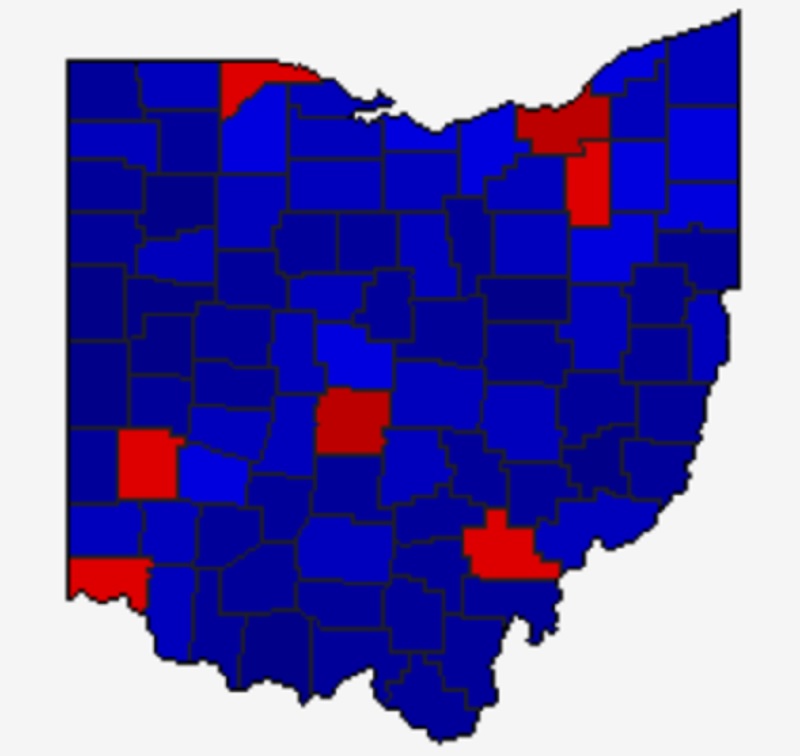
Only 3 metro counties- Delaware, Fairfield and Franklin- moved further blue since 2016. Franklin and Delaware moved strongly left, Fairfield only slightly. Delaware and Franklin also moved more blue from 2012 to 2016. Union stayed very similar to 2016. Delaware and Franklin are the 2 most urbanized counties in the metro, so it makes sense they moved bluer. The most rural counties tended to have the strongest movement to the right.

Total Metro Area
Democratic Votes
2020: 566,737
2016: 475,027
2012: 492,213
2008: 478,611
2004: 408,339
2000: 293,236
Republican Votes
2020: 479,089
2016: 429,930
2012: 427,173
2008: 426,492
2004: 448,541
2000: 356,299

2020 was the first election in which either party surpassed half a million votes.

Metro Area Margin Between Democratic and Republican Votes (Negative is Democrat, Positive is Republican)
2020: -87,648
2016: -45,097
2012: -65,040
2008: -52,119
2004: +40,202
2000: +63,063

2020 provided the largest margin for either party since 2000, and the metro has generally become more blue over time.


And here is the partisan vote breakdown by % since 2000.
Delaware County
Democratic
2020: 45.69%
2016: 38.69%
2012: 37,71%
2008: 39.59%
2004: 33.62%
2000: 30.93%
Republican
2020: 52.51%
2016: 54.50%
2012: 60.86%
2008: 59.17%
2004: 66.05%
2000: 66.13%
Fairfield County
Democratic
2020: 37.54%
2016: 33.83%
2012: 41.39%
2008: 40.54%
2004: 36.51%
2000: 35.24%
Republican
2020: 60.93%
2016: 60.25%
2012: 56.82%
2008: 57.63%
2004: 62.93%
2000: 61.97%
Franklin County
Democratic
2020: 64.68%
2016: 59.78%
2012: 60.53%
2008: 59.58%
2004: 54.35%
2000: 48.79%
Republican
2020: 33.40%
2016: 33.93%
2012: 37.75%
2008: 38.89%
2004: 45.12%
2000: 47.78%
Hocking County
Democratic
2020: 27.99%
2016: 29.20%
2012: 48.22%
2008: 48.09%
2004: 46.78%
2000: 41.60%
Republican
2020: 70.25%
2016: 65.72%
2012: 49.22%
2008: 48.89%
2004: 52.55%
2000: 53.01%
Licking County
Democratic
2020: 35.02%
2016: 32.74%
2012: 41.94%
2008: 41.09%
2004: 37.84%
2000: 37.13%
Republican
2020: 63.05%
2016: 61.28%
2012: 55.80%
2008: 56.82%
2004: 61.72%
2000: 59.52%
Madison County
Democratic
2020: 28.65%
2016: 27.43%
2012: 38.99%
2008: 37.30%
2004: 35.65%
2000: 36.05%
Republican
2020: 69.57%
2016: 66.76%
2012: 58.91%
2008: 60.57%
2004: 63.90%
2000: 60.63%
Morrow County
Democratic
2020: 21.92%
2016: 22.54%
2012: 36.59%
2008: 37.03%
2004: 35.37%
2000: 35.28%
Republican
2020: 76.22%
2016: 71.60%
2012: 60.83%
2008: 60.36%
2004: 64.15%
2000: 61.08%
Perry County
Democratic
2020: 24.57%
2016: 27.40%
2012: 46.82%
2008: 47.04%
2004: 47.78%
2000: 45.95%
Republican
2020: 74.10%
2016: 67.73%
2012: 50.78%
2008: 50.02%
2004: 51.72%
2000: 50.20%
Pickaway County
Democratic
2020: 25,79%
2016: 26.21%
2012: 40.09%
2008: 38.16%
2004: 37.54%
2000: 37.19%
Republican
2020: 72.70%
2016: 68.55%
2012: 58.11%
2008: 59.81%
2004: 61.97%
2000: 60.41%
Union County
Democratic
2020: 33.22%
2016: 27.87%
2012: 34.36%
2008: 35.07%
2004: 29.45%
2000: 29.61%
Republican
2020: 64.62%
2016: 65.34%
2012: 63.57%
2008: 63.02%
2004: 70.13%
2000: 67.56%

Metro Area Partisan % By Year
Democratic
2020: 53.18%
2016: 49.22%
2012: 52.58%
2008: 52.00%
2004: 47.42%
2000: 43.64%
Republican
2020: 44.96%
2016: 44.55%
2012: 45.63%
2008: 46.33%
2004: 52.08%
2000: 53.03%

% Margin Between Democratic and Republican Vote (Negative is Democratic, Positive is Republican)
2020: -8.22
2016: -4.67
2012: -6.95
2008: -5.67
2004: +4.66
2000: +9.39

To see national election results back to the 1700s, visit here:
US Election Atlas


Columbus Halloween Climatology


Columbus' Halloween climatology

Halloween in Columbus has historically not been as volatile as some other holidays. If anything, a bit of rain and chilly temperatures are what ruin the festivities more often than not. This post examines Columbus Halloween climatology across several categories. Data comes from historic records and the Wilmington National Weather Service.

Here are the temperature extremes that have occurred.

Top 10 Coldest Highs
1. 1906: 38
2. 1993: 39
3. 1878, 1895: 40
4. 1913, 1923, 1954: 41
5. 1885, 1917, 2012: 42
6. 1890: 43
7. 1908, 1925, 1926, 2017: 44
8. 1898, 1905: 45
9. 1930, 1976: 46
10. 1879, 1931, 2002: 47

Top 10 Coldest Lows
1. 1887: 20
2. 1962, 1988: 25
3. 1923: 27
4. 1908, 1925: 28
5. 1885, 1893, 1913, 1917, 1953, 1975: 29
6. 1904, 1906: 30
7. 1878, 1938, 1954, 1968: 31
8. 1928, 1934, 1949, 1958, 1964, 1976, 1980, 2000: 32
9. 1879, 1926, 1930, 2017: 33
10.1890, 1936, 1951, 1966, 1969, 1993, 1996, 2002, 2008, 2010: 34

Top 10 Coldest Means
1. 1906, 1923: 34
2. 1913: 35
3. 1878, 1885, 1908, 1917, 1925, 1954: 36
4. 1887, 1962, 1993: 37
5. 1895: 38
6. 1890, 1926, 1976, 1988, 2017 39
7. 1879, 1930, 2012: 40
8. 2002: 41
9. 1893, 1894, 1898, 1905, 1975, 1996: 42
10. 1939, 1955, 2010: 43

Top 10 Warmest Highs
1. 1950: 83
2. 1974: 80
3. 1900: 79
4. 1927, 1933: 78
5. 1979, 2003: 75
6. 1882, 1901, 1982, 1999: 74
7. 1909, 1990: 73
8. 1888, 1935, 1944, 1987 72
9. 1915, 1971: 71
10. 1919: 70

Top 10 Warmest Lows
1. 1919: 61
2. 1882: 60
3. 2003: 59
4. 1927, 1929: 58
5. 1900, 1956, 2013: 57
6. 1921, 1941, 1982, 2018: 56
7. 1950: 55
8. 1959, 1979: 54
9. 1971: 53
10. 1881, 1891, 1933, 1946, 1974, 1991: 52

Top 10 Warmest Means
1. 1950: 69
2. 1900, 1927: 68
3. 1882, 2003: 67
4. 1919, 1974: 66
5. 1933, 1979, 1982: 65
6. 1901, 1929, 1956: 63
7. 1971, 2013: 62
8. 1890, 1999: 61
9. 1909, 1921, 1935, 1941, 1946, 1991, 2018: 60
10. 1984, 2001: 59

Halloween High Temperatures by Occurrence since 1878
Below 40: 2
40-49: 27
50-59: 35
60-69: 59
70-79: 18
80 and Above: 2

Halloween Low Temperature by Occurrence since 1878
Below 20: 0
20-29: 12
30-39: 54
40-49: 51
50-59: 24
60 and Above: 2

And the precipitation extremes.

Top 10 Wettest
1. 2019: 1.51″
2. 1932: 1.44″
3. 2009: 1.21″
4. 2013: 0.98″
5. 1941: 0.97″
6. 1919: 0.91″
7. 2018: 0.63″
8. 1942: 0.51″
9. 1960: 0.45″
10. 1905, 1973: 0.43″

Halloween Precipitation by Amount Occurrence since 1878
None: 78
Trace: 11
0.01-0.24: 37
0.25-0.49: 9
0.50-0.99: 5
1.00 or More: 3

Snow has been very rare for Halloween, especially accumulating snow. 1993 saw the only time that an inch or more of snow fell.

Top 10 Snowiest
1. 1993: 1.0″
2. 1954: 0.2″
3. 1906, 1917, 1926, 1930, 2012, 2019: Trace


Does Fall Weather Correlate to Winter Severity?


winter severity

Republished with data through the 2019-2020 winter.

As we go into the winter season, it’s time to talk about how this one might end up. There’s a belief that fall weather is a good sign of how cold or warm winter will be. Let’s see if that holds true.

First, let’s just look at October temperatures.
The October normal mean temperature for Columbus is 55 degrees.

Between 1878 and 2019, there have been 47 Octobers that featured a mean temperature of 53.9 degrees or lower, what we’re considering a Cold October for the purposes of this comparison.
Of those 47 Octobers, 27 of the 47 had following winters that were colder than normal, or 57.4%, 13 had average temperature winters, or 27.7%, and the remaining 7 were warmer than normal, or 14.9%.
Interestingly, this category contains both the warmest winter on record- 1889-1890 and the coldest on record- 1976-1977- as shown by the chart below.

Next, we look at Normal Octobers, which are +/- 1 degree of the 1981-2010 Average of 55 degrees.
Between 1878 and 2019, there were 45 normal Octobers. Of those, 21 had colder than normal following winters, or 46.7%. 11 were followed by normal winters, or 24.4%, and 13 had warmer than normal winters, or 28.9%.

Finally, let’s look at warm Octobers, which are those with means of 56.1 degrees or higher. There were 49 Octobers with warmer than normal means since 1878. Of those, 18 featured following winters that were colder than normal, or 36.7%. Another 19, or 38.8%, were followed by average winters. The final 12 winters, or 24.5%, were warmer than normal. Here’s the graph.

So just based on the October mean temperature, Octobers that are colder than normal are almost twice as likely as normal Octobers and almost 4x as likely as warm Octobers to be followed by a cold winter. But what about Novembers? It is closer to winter itself, so does its weather matter even more?

Colder than normal Novembers- 43.3 degrees or lower- included 80 Novembers since 1878. Of those, 38 or 47.5% had colder than normal winters. 22 (27.5%) had normal winters and 19, or 23.8%, had warmer than normal winters.

With the 39 normal Novembers, 43.4 to 45.4 degrees, there were 18 that had colder than normal winters, or 46.2%, with 12 normal winters (30.8%) and 9 warmer than normal winters (23.1%).

Finally, there were 24 warmer than normal Novembers since 1878- 45.5 degrees or higher. Only 6, or 25%, were followed by cold winters. An additional 9 (37.5%) were normal, while the last 9 (37.5%) were warmer than normal.

To reiterate, here are the ranked percentages of cold winters by the preceding October or November.
1. Cold Octobers: 57.4%
2. Cold Novembers: 47.5%
3. Normal Octobers: 46.7%
4. Normal Novembers: 46.2%
5. Warm Octobers: 36.7%
6. Warm Novembers: 25.0%

It should be no surprise that cold Octobers and Novembers have a stronger correlation to the following winters also being colder, with colder winters becoming increasingly unlikely as those months warm. What is surprising is that October weather, across the board, was more predictive of cold winters than Novembers were.

Going further, though, what about bi-monthly combinations?

Rank of Bi-Monthly Combinations and the percentage of colder than normal following winters, along with total years in sample:
Normal October/Normal November: 87.5% 8 Years
Cold October/Warm November: 57.1% 7 Years
Cold October/Cold November: 53.8% 26 Years
Normal October/Cold November: 48.1% 27 Years
Warm October/Cold November: 40.7% 27 Years
Cold October/Normal November: 38.5% 13 Years
Warm October/Warm November: 28.6% 7 Years
Warm October/Normal November: 25.0% 16 Years
Normal October/Warm November: 0.0% 8 Years

So a normal fall is clearly the best, but the sample size is not particularly high. Normal to Warm is unanimously warm, but again, it has a small sample size.

So does fall weather ultimately have a correlation to winter severity? To some degree yes, as patterns established in the fall tend to appear in the winter as well, but October, rather than November, has a clear higher correlation. But as with everything, there are many other factors involved.

October 2020 looks to at least begin with below normal temperatures, but it remains to be seen how it ends up.

To see records for Columbus falls and winters going back to 1878, visit the following links.
Autumn Weather Records
Winter Season Records

And to see current local weather and forecasts, visit: Wilmington National Weather Service


Ohio Census 2020 Response Rates


Ohio census 2020 response rates

The 2020 US Census is currently winding down, perhaps somewhat earlier than planned, but wrapping up nonetheless.
The accuracy of the Census relies heavily on enough people responding to the surveys. Because of the pandemic this year, the internet has played a bigger role in the response rates than normal, but there were still plenty of door to door workers doing surveys. How did Columbus, Central Ohio and other parts of the state do? Here are the Ohio census 2020 response rates.

First, let’s look at Ohio counties. These numbers are through September 2nd.

Top 10 counties for Census Response
1. Medina County: 81.9%
2. Delaware County: 79.7%
3. Geauga County, Warren County: 78.7%
4. Union County: 78.0%
5. Lake County: 77.4%
6. Auglaize County: 76.9%
7. Wayne County: 76.8%
8. Greene County: 76.0%
9. Miami County: 75.9%
10. Fulton County: 75.2%

Bottom 10 Counties for Census Response
1. Harrison County: 55.5%
2. Morgan County: 57.7%
3. Vinton County: 57.9%
4. Pike County: 58.5%
5. Monroe County: 58.8%
6. Lawrence County: 59.3%
7. Scioto County: 59.4%
8. Meigs County: 59.6%
9. Adams County: 59.9%
10. Ashtabula County, Athens County: 60.8%

Most of the high-reporting counties were large metro counties, while most of the low ones were Appalachia. This may be related to access to the internet, which again, played a crucial role this year.

Here are the counties that anchor Ohio’s largest metros
Lucas County: 64.6%
Cuyahoga County: 65.5%
Franklin County: 66.7%
Hamilton County: 66.7%
Mahoning County: 67.4%
Montgomery County: 68.0%
Stark County: 74.3%

Columbus’ Franklin County was tied for 3rd worst.

Now let’s look at Central Ohio cities and towns.
Minerva Park: 88.6%
Worthington: 86.8%
Upper Arlington: 85.7%
Westerville: 83.2%
Dublin: 82.7%
Canal Winchester: 81.8%
Grandview Heights: 81.8%
Gahanna: 81.1%
New Albany: 81.1%
Bexley: 79.5%
Grove City: 78.9%
Groveport: 78.9%
Pataskala: 77.4%
Hilliard: 77.0%
Valleyview: 76.5%
Reynoldsburg: 75.3%
Obetz: 72.7%
Pickerington: 71.6%
Columbus: 62.1%
Whitehall: 58.5%

Generally, the more urban commmunities tended to do worse than the outer suburbs. This has implications on urban areas possibly being undercounted, though the response rates are generally similar to what they were in 2010, so that concern is probably overblown to some extent.

If your’e interested in taking a further look at Ohio’s and other states numbers, visit the following link, in which response rates are tracked all the way down to the Census Tract level: https://2020census.gov/en/response-rates/self-response.html


Cool Link: Columbus Urban Forestry Plan

Only about 22% of Columbus’ land is made up by tree cover, which is lower than many of its national peers. Because of this, the city has come up with the Columbus Urban Forestry Plan, which in part seeks to plant millions of trees in the coming years, potentially beginning next year. You can view the plan, timeline, tree canopy statistics and neighborhood maps all the way down to a block by block level at the following link: Forestry Plan