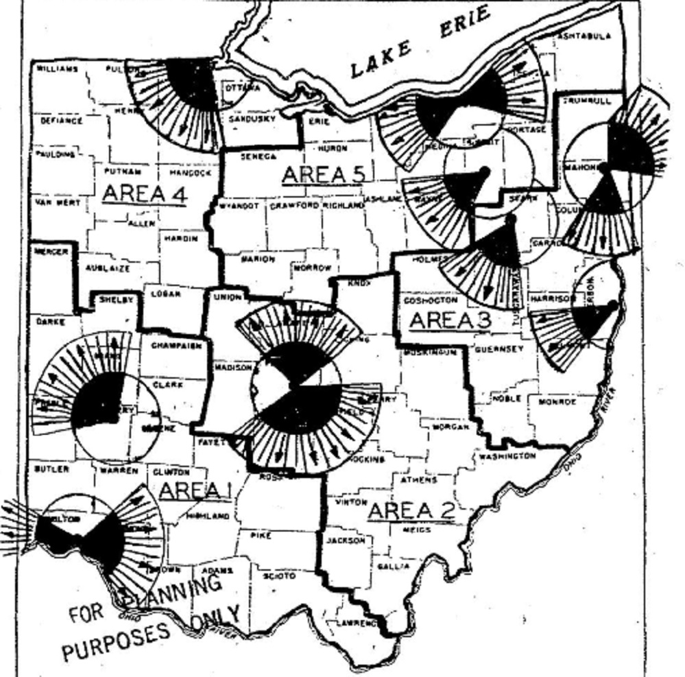
In this short edition of Strange Columbus Things, we look at Ohio’s atomic bomb evacuation routes. Back in the 1950s, many were still grappling with the implications of the birth of the Atomic Age. The US was busily testing bombs both on and outside of US soil, and souring relationships with international adversaries presented the threat of nuclear war. In March, 1955, the director of Ohio’s Civil Defense, Major General Leo M. Kreber, release evacuation routes for Ohio’s major cities should an attack take place.
For Columbus, it was either north or south. In the description of why these directions are preferred, it was suggested that it was to prevent conflict with evacuees from the Dayton area to the west, but in reality, the truth is much darker. In the event of a nuclear attack, it wouldn’t just be Columbus. Dayton and Cincinnati would also be hit, and due to prevailing winds in this part of the world, fallout would generally move eastward. Therefore, the safest routes were thought to be up towards Morrow County or south and southeast towards Hocking County. The logic hasn’t changed much in the past 70 years. North and south would still be the safest evacuation routes. However, evacuation from targeted locations would only offer temporary refuge. The cruel reality is that in the event of a true, global nuclear war, few places anywhere on the planet would be left unscathed. If not destroyed by bombs or irradiated by fallout, nuclear winter would bring incredibly devastation to most of the planet, even those completely untouched by bombs. As true today as it was in 1955, the only way to really be safe is for no one to ever push the button.
Iuka Ravine, much like Glen Echo Ravine to its north, is a hidden gem in the heart of the city. Columbus isn’t exactly known for its interesting topography, so such features offer welcome variety from the otherwise endless flatness of Central Ohio. That the feature sits in the middle of the Campus area makes it even more special.
Iuka Ravine was named by Robert Neil when he returned home from the Civil War and built a home along it. Neil gave names to many local streets in the area, all based on his time in the Union Army and the places he had visited. He named the ravine after the Battle of Iuka, and Indianola Avenue was named after the location of that battle, Indianola, Mississippi.
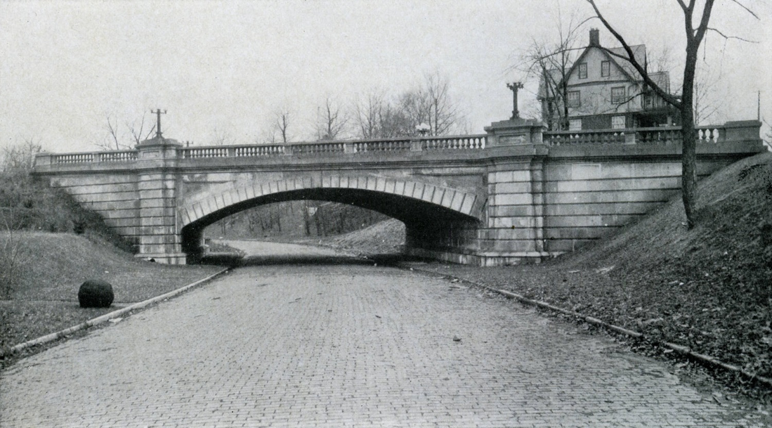
The ravine went largely untouched until the early part of the 20th Century. Large homes sprung up along its edges beginning in the early 1900s, built to take advantage of the natural scenery. Iuka Avenue seems to have been built around 1905 given references for it don’t appear in any media before then. In 1912, Iuka Avenue was improved and the viaducts were built over the ravine at Indianola and Summit.
Before The before photo shows the Indianola viaduct over Iuka Avenue in 1916. Strangely enough, the ravine appears rather treeless, most likely due to construction of the viaducts and improvements 4 years prior to the time of the photo. A large building behind the bridge to the right was home to the Chi Phi fraternity at 2000 Indianola Avenue.
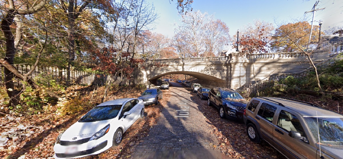
After In the 2020 image, Iuka Ravine is now filled with trees- and, unfortunately, many cars- but otherwise remains remarkably untouched. Even the old Chi Phi house can still be seen peeking above the viaduct.
Over the years, Iuka has been threatened by development, but is now on the National Register of Historic Places. This popular running road and adjacent Iuka Park will likely continue to offer a bit of nature in the growing city for generations to come.
The Battle of Iuka was not a huge battle overall in comparison to other Civil War events, but over 400 soldiers still lost their lives during the fighting.
For a long time, Columbus has had a reputation for having a relatively easy commute, at least in terms of driving. Its abundant highway and road system allowed commuters to travel to work quickly, with most commutes 20 minutes or less. However, as the city has grown and traffic has increased, the local commute may not be as quick as it once was. Story after story has shown that Columbus’ commute is steadily getting worse.
This post seeks to answer both how people are getting to work, how fast they get to work, and how commuters in Columbus differ from those in other cities. For this comparison, I used cities from metro areas most similar to Columbus’ size- 1.5-2.5 million- as well as major Midwest and Ohio cities.
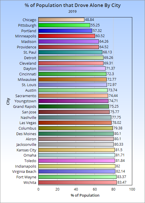
First, let’s look at just how people get to work by the % of workers in 2019, the latest year available.
Out of the 31 cities looked out, Columbus is the 10th most car-dependent city. It is also the 3rd most car-dependent in Ohio after Akron and Toledo.
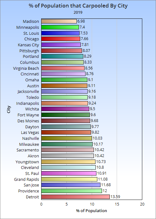
The heavy use of cars in Columbus did not translate to more people carpooling.
With only the COTA bus system available, the portion of the population that uses public transit is also in the bottom half. This despite the city seeing strong bus ridership growth over the last several years.
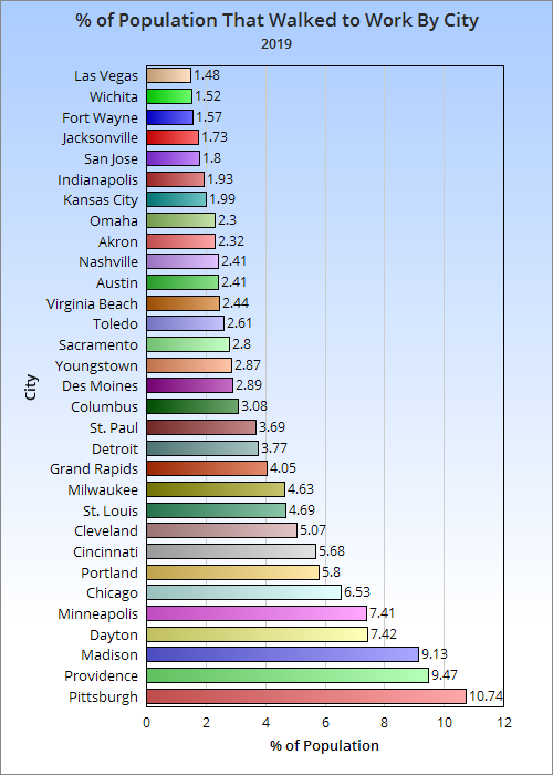
Columbus sat right in the middle of cities with the number of walking commuters. Several parts of the city lack sufficient walking infrastructure. For example, large parts of Linden and the South Side were built without sidewalks of any kind. Crosswalks and other safety features are also lacking in many areas.
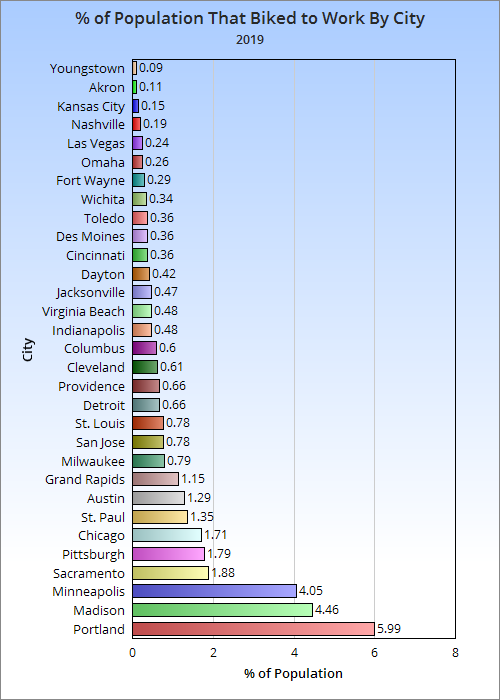
Columbus is again in the middle of the pack on biking commutes, and again infrastructure is the likely reason. There is only a single section of one bike lane that is protected anywhere in the city. Creating more bike lanes, let alone protected ones, remains a low priority for the city. Instead, they have relied on “Shared Use” type signage, along with painting sharrows.
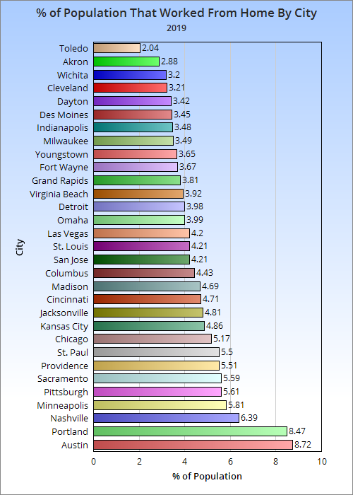
Columbus was in the top half of at-home workers. These numbers were all prior to the pandemic, so it’s likely that there will be significant increases in long-term or permanent home workers in post-2019 numbers.
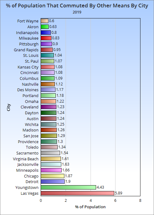
Other types of commuting include everything from taxis to commercial airline flights.
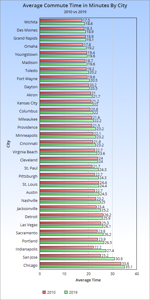
Columbus was in the bottom half of cities for the average commute time. Like almost everywhere else, that time has been increasing, however. Columbus saw the 11th biggest commute time increase and had the 2nd largest in Ohio. With its far larger population growth recently and predicted, that commute time is only going to get worse.
It’s pretty clear that Columbus has significant car dependency. With increasing commute times, it is crucial to plan for how people will get to work in the future. That is why it’s so important that new development is built to be walkable and dense while the average commute is still relatively short. This will promote walking, biking and new transit forms, all of which is better for a more vibrant, healthier city. It will also perhaps keep the number of cars on the road from growing as much. To assist in this process, the city must invest in more pedestrian and bike-friendly infrastructure, while also writing building codes that promote better planning in development.
To be fair, Columbus has made some progress. In 2010, the % of the population that drove alone was 80.76%, 1.38 points above where it was in 2019. Furthermore, the city has promoted more bus usage with its CPASS program. That said, the culture changes could’ve been much better had more policy and infrastructure been in place years ago like many other cities have had. Columbus has a lot of work to do.
Columbus is the 2nd largest city in the United States without any form of passenger rail. It hasn’t had passenger rail since the last train pulled out of Union Station in 1977. Some might argue that rail is an outdated form of transit, and therefore unnecessary anyway. Others argue that not having a multi-modal transit system holds the city back economically and developmentally.
However one views rail, Amtrak’s latest national route plan, called Connect US is still arguably mediocre. In fact, one could say that the new Amtrak route plan underserves Columbus completely.
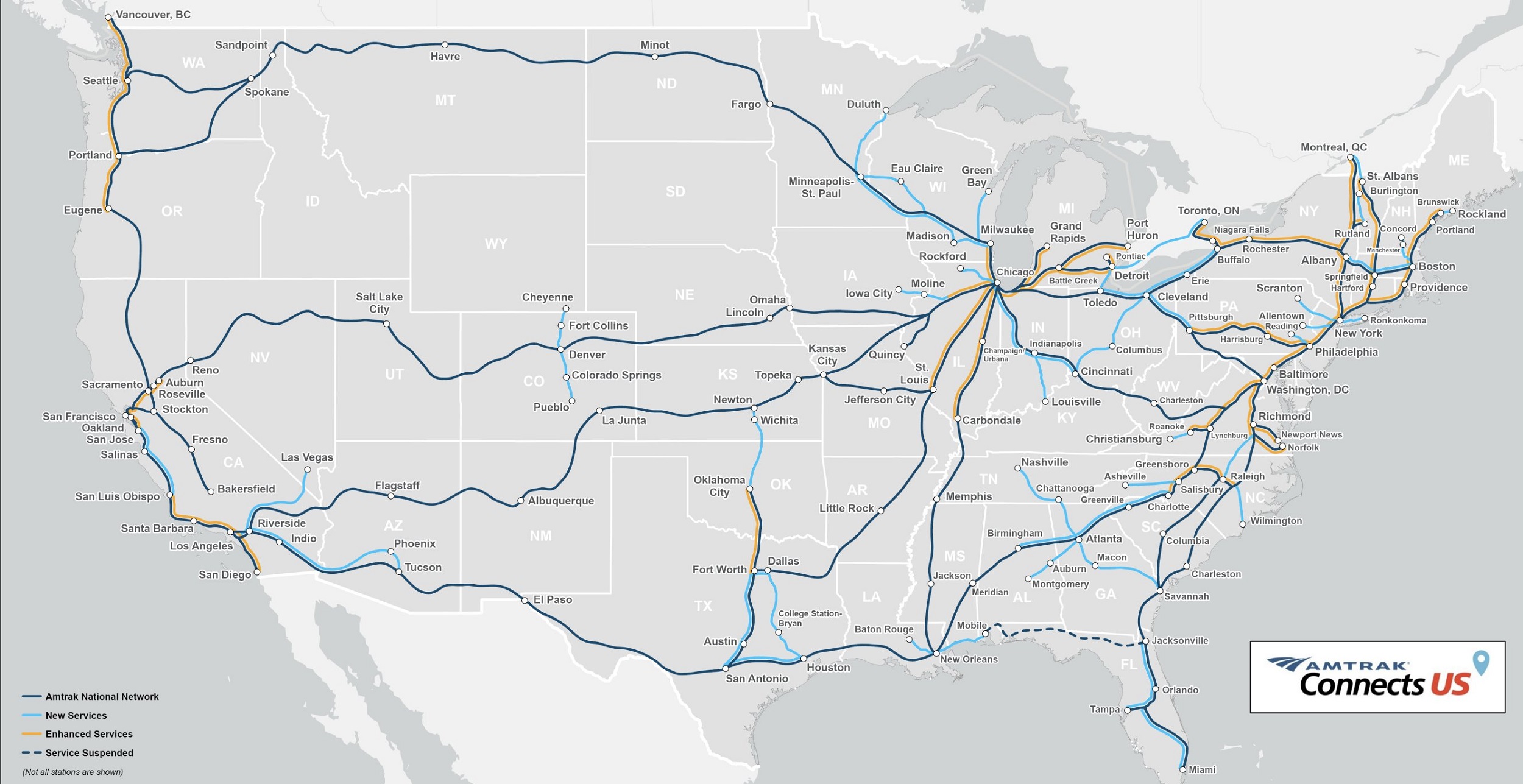
The route plan.
As shown in the above map, Columbus would only have direct connections to Cincinnati and Cleveland. To go anywhere else, passengers from Columbus would first have to travel to those cities and then make transfers. While a direct connection to Cleveland and Cincinnati is important, this plan would present more of a challenge to potential travelers who want direct connections outside of the state. Columbus is currently the largest city in Ohio and will soon be the largest metro area. It is one of the fastest-growing cities in the United States and has added more people the past 10 years than any other Midwest city. On top of all that, it is the capital of the 7th most-populated state.
Amtrak’s plan attempts to largely use existing rail lines, but in many places the routes would be brand new. Columbus doesn’t have existing passenger rail routes, so it may be more expensive to build them there. However, it seems to be a wasted opportunity to not make Columbus more of the state’s hub by having direct connections to cities like Chicago, Indianapolis and Pittsburgh. Incidentally, the proposed Hyperloop project would be a Chicago-Columbus-Pittsburgh route that would eventually connect all the way to New York. Most people view Hyperloop as a gimmick more than a real proposal, so more traditional rail is still taken more seriously.
It is in all our best interests to want the best possible infrastructure. Amtrak’s plan treats Columbus as a 2nd or 3rd-rate city. That’s unfortunate, and works against all the momentum the city has had in recent decades. The current Amtrak plan would provide less economic benefit and options to Ohio’s fastest-growing city and capital. The city deserves so much better than being an afterthought.
The Transportation Climate Impact Indexmeasures how the 100 largest US metros rank in terms of climate impact from everything from walkability to vehicles miles.
Ohio cities don’t rank highly, unfortunately. Columbus clocks in at #85, with its worst ranking coming from how much its residents drive. Columbus’ bus system only goes so far, and without any other form of transit, much of the area is completely car-dependent.