2020 Census State Populations


2020 census state populations

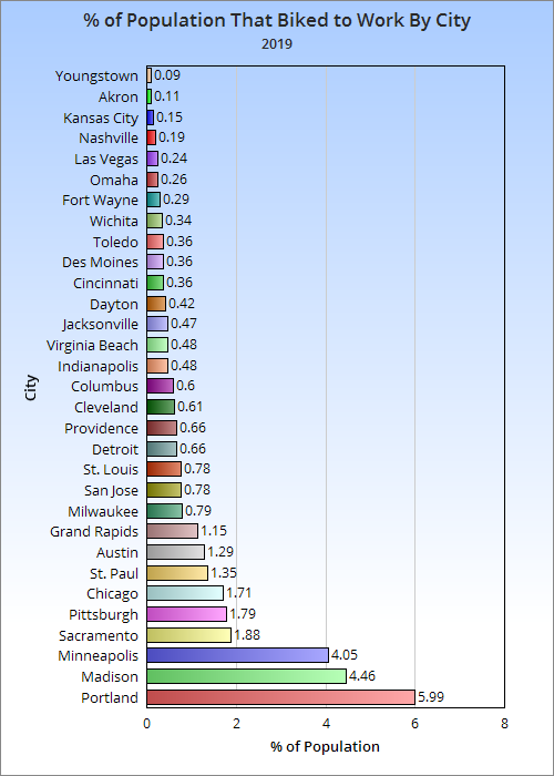
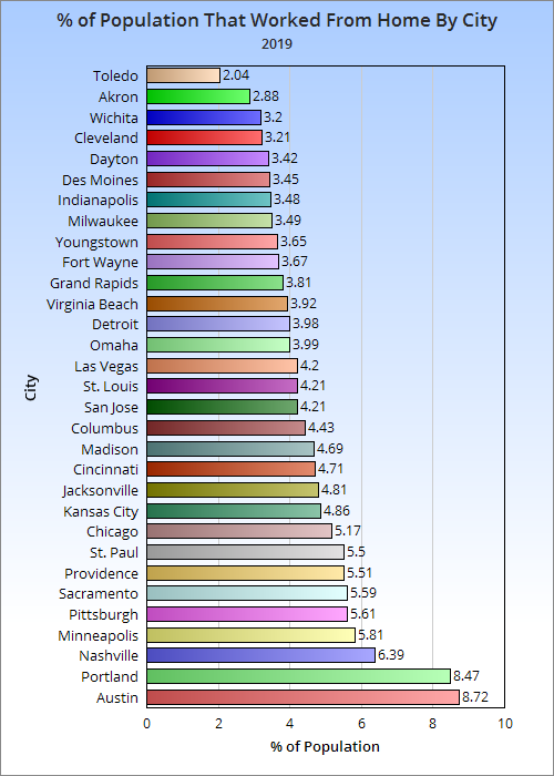
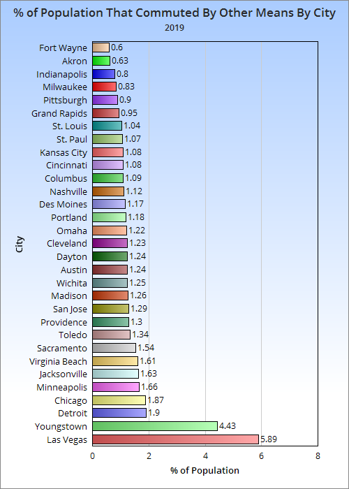
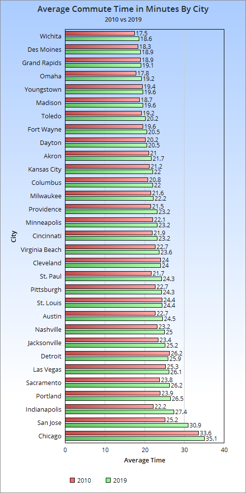
Happy day! The 2020 Census data is finally beginning to be released after months of delays, including 2020 census state populations. Let’s take a look.

State Population Census 2010 vs. 2020 Estimate vs. 2020 Census
2010 Census———————–2020 Estimate——————-2020 Census
1. California:37,253,956—–1. California: 39,368,078—- 1. California: 39,538,223
2. Texas: 25,145,561———-2. Texas: 29,360,759———2. Texas: 29,145,505
3. New York: 19,378,102—–3. Florida: 21,733,312——–3. Florida: 21,538,187
4. Florida: 18,801,310———4. New York: 19,336,776—-4. New York: 20,201,249
5. Illinois: 12,830,632———-5. Pennsylvania: 12,783,254–5. Pennsylvania: 13,002,700
6. Pennsylvania: 12,702,379-6. Illinois: 12,587,530——–6. Illinois: 12,812,508
7. Ohio: 11,536,504————-7. Ohio: 11,693,217———-7. Ohio: 11,799,448
8. Michigan: 9,883,640———8. Georgia: 10,710,017——8. Georgia: 10,711,908
9. Georgia: 9,687,653———-9. N. Carolina: 10,600,823–9. N. Carolina: 10,439,388
10. N. Carolina: 9,535,483—-10. Michigan: 9,966,555—–10. Michigan: 10,077,331
11. New Jersey: 8,791,894—-11. New Jersey: 8,882,371–11. New Jersey: 9,288,994
12. Virginia: 8,001,024———-12. Virginia: 8,590,563——-12. Virginia: 8,631,393
13. Washington: 6,724,540—–13. Washington: 7,693,612–13. Washington: 7,705,281
14. Massachusetts: 6,547,629–14. Arizona: 7,421,401——14. Arizona: 7,151,502
15. Indiana: 6,483,802—-15. Massachusetts: 6,893,574–15. Massachusetts: 7,029,917
16. Arizona: 6,392,017———–16. Tennessee: 6,886,834–16. Tennessee: 6,910,840
17. Tennessee: 6,346,105——-17. Indiana: 6,754,953——-17. Indiana: 6,785,528
18. Missouri: 5,988,927———–18. Missouri: 6,151,548——18. Maryland: 6,177,224
19. Maryland: 5,773,552———-19. Maryland: 6,055,802—–19. Missouri: 6,154,913
20. Wisconsin: 5,686,986———20. Wisconsin: 5,832,655—-20. Wisconsin: 5,893,718
21. Minnesota: 5,303,925———21. Colorado: 5,807,719—-21. Colorado: 5,773,714
22. Colorado: 5,029,196———–22. Minnesota: 5,657,342—-22. Minnesota: 5,706,494
23. Alabama: 4,779,736———23. S. Carolina: 5,218,040——23. S. Carolina: 5,118,425
24. S. Carolina: 4,625,364———24. Alabama: 4,921,532——24. Alabama: 5,024,279
25. Louisiana: 4,533,372———-25. Louisiana: 4,645,318——25. Louisiana: 4,657,757
26. Kentucky: 4,339,367———–26. Kentucky: 4,477,251——26. Kentucky: 4,505,836
27. Oregon: 3,831,074————–27. Oregon: 4,241,507——–27. Oregon: 4,237,256
28. Oklahoma: 3,751,351———-28. Oklahoma: 3,980,783—–28. Oklahoma: 3,959,353
29. Connecticut: 3,574,097——29. Connecticut: 3,557,006—29. Connecticut: 3,605,944
30. Iowa: 3,046,355—————-30. Utah: 3,249,879————30. Utah: 3,271,616
31. Mississippi: 2,967,297——–31. Iowa: 3,163,561———–31. Iowa: 3,190,369
32. Arkansas: 2,915,918———-32. Nevada: 3,138,259——-32. Nevada: 3,104,614
33. Kansas: 2,853,118————-33. Arkansas: 3,030,522——33. Arkansas: 3,011,524
34. Utah: 2,763,885—————–34. Mississippi: 2,966,786—-34. Mississippi: 2,961,279
35. Nevada: 2,700,551————-35. Kansas: 2,913,805———35. Kansas: 2,937,880
36. New Mexico: 2,059,179—-36. New Mexico: 2,106,319—36. New Mexico: 2,117,522
37. W. Virginia: 1,852,994——–37. Nebraska: 1,937,552——-37. Nebraska: 1,961,504
38. Nebraska: 1,826,341———38. Idaho: 1,826,913———–38. Idaho: 1,839,106
39. Idaho: 1,567,582—————39. W. Virginia: 1,784,787—–39. W. Virginia: 1,793,716
40. Hawaii: 1,360,301————40. Hawaii: 1,407,006———-40. Hawaii: 1,455,271
41. Maine: 1,328,361——–41. N. Hampshire: 1,366,275—41. N. Hampshire: 1,377,529
42. N. Hampshire: 1,316,470—-42. Maine: 1,350,141——–42. Maine: 1,362,359
43. Rhode Island: 1,052,567—–43. Montana: 1,080,577—-43. Rhode Island: 1,097,379
44. Montana: 989,414———-44. Rhode Island: 1,057,125——–44. Montana: 1,084,225
45. Delaware: 897,934————45. Delaware: 986,809———45. Delaware: 989,948
46. S. Dakota: 814,180———–46. S. Dakota: 892,717——–46. S. Dakota: 886,667
47. Alaska: 710,231————–47. N. Dakota: 765,309——–47. N. Dakota: 779,094
48. N. Dakota: 672,591———–48. Alaska: 731,158———–48. Alaska: 733,391
49. Vermont: 625,741——-49. Washington DC: 712,816—-49. Washington DC: 689,545
50. Washington DC: 601,723——-50. Vermont: 623,347———-50. Vermont: 643,077
51. Wyoming: 563,626————-51. Wyoming: 582,328———-51. Wyoming: 576,851

In many cases, the 2020 estimates had significant errors. New York was found to have more than 800,000 people above what the estimate was. The estimate assumed the state had lost population the past decade, but it had actually gained well over 800,000. Ohio was also undercounted by more than 106,000. In general, the Census estimates had Northern states with either too large losses/too slow growth than reality, while Southern states were generally estimated to have grown more than they really did. This has been a long-standing bias within the Census estimates program.


Total Population Change Comparison By Decade
2000-2010——————————————2010-2020
1. Texas: 4,293,741————————–1. Texas: 3,999,944
2. California: 3,382,308———————2. Florida: 2,736,877
3. Florida: 2,818,932————————3. California: 2,284,267
4. Georgia: 1,501,200———————–4. Georgia: 1,024,255
5. N. Carolina: 1,486,170——————-5. Washington: 980,741
6. Arizona: 1,261,385————————6. N. Carolina: 903,905
7. Virginia: 922,509—————————7. New York: 823,147
8. Washington: 830,419———————8. Arizona: 759,485
9. Colorado: 727,934————————-9. Colorado: 744,518
10. Nevada: 702,294——————–     10. Virginia: 630,369
11. Tennessee: 656,822——————–11. Tennessee: 564,735
12. S. Carolina: 613,352——————-12. Utah: 507,731
13. Utah: 530,716—————————-13. New Jersey: 497,100
14. Maryland: 477,066———————-14. S. Carolina: 493,061
15. Pennsylvania: 421,325————— -15. Massachusetts: 482,288
16. Illinois: 411,339————————–16. Oregon: 406,182
17. Oregon: 409,675————————17. Nevada: 404,063
18. Indiana: 403,317————————18. Maryland: 403,672
19. New York: 401,645———————-19. Minnesota: 402,569
20. Missouri: 393,716———————–20. Indiana: 301,726
21. Minnesota: 384,446———————21. Pennsylvania: 300,321
22. New Jersey: 377,544——————-22. Idaho: 271,524
23. Alabama: 332,645———————–23. Ohio: 262,944
24. Wisconsin: 323,311———————24. Alabama: 244,543
25. Oklahoma: 300,697———————25. Oklahoma: 208,002
26. Kentucky: 297,598———————-26. Wisconsin: 206,732
27. Idaho: 273,629—————————27. Michigan: 193,691
28. Arkansas: 242,518———————-28. Kentucky: 166,469
29. New Mexico: 240,133——————29. Missouri: 165,986
30. Massachusetts: 198,532————–30. Iowa: 144,014
31. Ohio: 183,364—————————31. Nebraska: 135,163
32. Connecticut: 168,532——————32. Louisiana: 124,385
33. Kansas: 164,700————————33. N. Dakota: 106,503
34. Hawaii: 148,764————————-34. Arkansas: 95,606
35. Mississippi: 122,639——————–35. Hawaii: 94,970
36. Iowa: 120,031—————————-36. Montana: 94,810
37. Nebraska: 115,078———————-37. Delaware: 92,014
38. Delaware: 114,334———————-38. Washington DC: 87,822
39. Montana: 87,220————————39. Kansas: 84,762
40. Alaska: 83,299—————————40. S. Dakota: 72,487
41. N. Hampshire: 80,684—————–41. N. Hampshire: 61,059
42. Wyoming: 69,844———————–42. New Mexico: 58,343
43. Louisiana: 64,396———————–43. Rhode Island: 44,812
44. S. Dakota: 59,336———————–44. Maine: 33,998
45. Maine: 53,438—————————-45. Connecticut: 31,847
46. W. Virginia: 44,650———————-46. Alaska: 23,160
47. N. Dakota: 30,391———————–47. Vermont: 17,336
48. Washington DC: 29,664—————48. Wyoming: 13,225
49. Vermont: 16,914————————-49. Mississippi: -6,018
50. Rhode Island: 4,248——————–50. Illinois: -18,124
51. Michigan: -54,804———————–51. W. Virginia: -59,278

Rank by Difference between 2010-2020 vs. 2000-2010
1. New York: +421,502
2. Massachusetts: +283,756
3. Michigan: +248,495
4. Washington: +150,322
5. New Jersey: +119,556
6. Ohio: +79,580
7. North Dakota: +76,112
8. Louisiana: +59,989
9. Washington DC: +58,158
10. Rhode Island: +40,564
11. Iowa: +23,983
12. Nebraska: +20,085
13. Minnesota: +18,123
14. Colorado: +16,584
15. South Dakota: +13,151
16. Montana: +7,590
17. Vermont: +422
18. Idaho: -2,105
19. Oregon: -3,493
20. Maine: -19,440
21. New Hampshire: -19,625
22. Delaware: -22,320
23. Utah: -22,985
24. Hawaii: -53,794
25. Wyoming: -56,619
26. Alaska: -60,139
27. Maryland: -73,394
28. Kansas: -79,938
29. Florida: -82,055
30. Alabama: -88,102
31. Tennessee: -92,087
32. Oklahoma: -92,695
33. Indiana: -101,591
34. West Virginia: -103,928
35. Wisconsin: -116,579
36. South Carolina: -120,291
37. Pennsylvania: -121,004
38. Mississippi: -128,657
39. Kentucky: -131,129
40. Connecticut: -136,685
41. Arkansas: -146,912
42. New Mexico: -181,790
43. Missouri: -227,730
44. Virginia: -292,140
45. Texas: -293,797
46. Nevada: -298,231
47. Illinois: -429,463
48. Georgia: -476,945
49. Arizona: -501,900
50. North Carolina: -582,265
51. California: -1,098,041

Total Change By Region Between 2000-2010 and 2010-2020
South: -2,571,014
Midwest: -475,772
Northeast: +531,490
West: -2,104,601

Ohio moved into the top 25 in total growth and was one of the top states for the biggest improvement between the 2000s and 2010s. However, because it was already one of the most-populated states in the nation, its total growth still wasn’t enough for it to not lose another House district. The state will have to keep improving if it wants to maintain its level of representation in Congress.
Meanwhile, the fast-growing South and West regions clearly slowed down in growth the past decade. Combined, they added 4.675 million fewer people the past decade than they did during the 2000s. The Midwest was more of a mixed bag, with more states improving, but Illinois cancelling out all of that positive momentum. Only the Northeast managed to add more people the past decade than it did during the 2000s, mostly led by a huge improvement in New York.

The Census will release 2020 population numbers for counties, cities and other places over the next few months, and will be posted here when they are.

For more local and national population data, follow the links.
United States Census
Columbus City Population and Demographics
Columbus Metro Area Population and Demographics
Columbus vs. Other Places


Before and After History: Dublin’s Stone Bridge


Bridge Street gets its name from the lone bridge that has connected Dublin with areas east of the Scioto River for well over a century. Dublin’s stone bridge, however, is not original. It is the 3rd iteration over the lifespan of the crossing, replacing an 1879 iron version that replaced the original wooden covered bridge. The iron bridge crossed the river just to the north of the current bridge.

The bridge was constructed between 1935-1936. It was built by the Works Progress Administration (WPA), a Depression-era infrastructure building and jobs program. The project employed about 300 workers.

Since its construction, the bridge has been repaired and altered several times, with the original roadway itself now much wider than it once was.

Construction of the bridge in 1935.

An aerial photo of the old iron bridge taken around 1934.

The new bridge around 1937.

The bridge in the present.

Much has changed between the old images and the present one. Long gone are the fields and quieter life of 1930s Dublin.


Late Season Snowfalls Through History


Much to the potential annoyance of many, parts of Ohio- including Columbus are predicted to see a late-season snowfall Tuesday night into Wednesday morning. As late as it may seem, Columbus has seen even later season snowfalls since 1878. Though rare, these events do happen, and have sometimes been significant.

late season snowfalls Columbus, Ohio

The US weather map on the morning of May 21, 1883.

The absolute latest measurable snow occurred on May 21st, 1883, when 0.4″ fell. The amount was not impactful, but the date certainly was. People are normally thinking about summer by then, but instead got a nasty taste of winter. The present-day I-71 corridor in the state generally had had an inch or less- Cincinnati had upwards of 2″, with 3″ near Hamilton. However, areas just to the north and west were hammered with the heaviest May snow ever recorded.

An excerpt from the book “Thunder in the Heartland” by Thomas W. Schmidlin:
“A drizzling rain on Monday morning, 21 May, turned to snow at 9AM, and the air was filled with large, damp flakes all day. The Sidney Journal reported that ‘though it thawed, it lay six inches deep on Tuesday morning.’ Considering that much of the snow melted as it fell, a total of fifteen to twenty inches was estimated for Sidney. Snow depts of ten inches were measured on the north side of buildings at Houston in Shelby County.”

The Columbus Dispatch reported that snow fell in every major city from Lancaster north and west. Crops and trees were damaged by the heavy, wet snow across Western Ohio during the event. Temperatures at most locations were at or above freezing during the snow, so it did not stick around long after. Just 3 days later, it hit 80 degrees in Columbus.

Dates of Measurable Snowfalls After April 15th
1. May 21, 1883: 0.4″
2. May 9, 1923: 0.3″
3. May 7, 1989: 0.8″
4. April 30, 1908: 2.4″
5. April 24, 2005: 3.0″
6. April 22, 1893: 0.8″
6. April 22, 1901: 0.1″
7. April 21, 1934: 0.4″
7. April 21, 1936: 0.2″
7. April 21, 1953: 0.2″
8. April 20, 1910: 2.4″
8. April 20, 1962: 0.1″
9. April 19, 1887: 0.1″
9. April 19, 1907: 0.4″
9. April 19, 1969: 0.5″
9. April 19, 2019: 0.3″
10. April 18, 1983: 0.1″
10. April 18, 1984: 0.3″
11. April 17, 1961: 1.0″
11. April 17, 2001: 0.6″
12. April 16, 1935: 0.4″
12. April 16, 1956: 0.3″
12. April 16, 1996: 0.1″

Trace amounts have occurred many additional times after April 15th, including into early May. Measurable snow, however, has only occurred 23 times after April 15th since 1878. So snow after that date has occurred roughly once out of every 6.2 years. That rate is not going to be matched this time, as measurable snow fell on April 19th last year. Snow is predicted sometime tomorrow night, the 20th. If it ends up being measurable, it would fall into the tie of 8th latest such ever recorded.

To see more winter season records and local weather information and forecasts, go to the below links.
Wilmington National Weather Service
Winter Season Records
Winter Storms


Columbus Commute Comparison to Other Cities


Columbus commute comparison

Light Rail in Portland, Oregon

For a long time, Columbus has had a reputation for having a relatively easy commute, at least in terms of driving. Its abundant highway and road system allowed commuters to travel to work quickly, with most commutes 20 minutes or less. However, as the city has grown and traffic has increased, the local commute may not be as quick as it once was. Story after story has shown that Columbus’ commute is steadily getting worse.

This post seeks to answer both how people are getting to work, how fast they get to work, and how commuters in Columbus differ from those in other cities. For this comparison, I used cities from metro areas most similar to Columbus’ size- 1.5-2.5 million- as well as major Midwest and Ohio cities.

First, let’s look at just how people get to work by the % of workers in 2019, the latest year available.

Out of the 31 cities looked out, Columbus is the 10th most car-dependent city. It is also the 3rd most car-dependent in Ohio after Akron and Toledo.

The heavy use of cars in Columbus did not translate to more people carpooling.

With only the COTA bus system available, the portion of the population that uses public transit is also in the bottom half. This despite the city seeing strong bus ridership growth over the last several years.

Columbus sat right in the middle of cities with the number of walking commuters. Several parts of the city lack sufficient walking infrastructure. For example, large parts of Linden and the South Side were built without sidewalks of any kind. Crosswalks and other safety features are also lacking in many areas.


Columbus is again in the middle of the pack on biking commutes, and again infrastructure is the likely reason. There is only a single section of one bike lane that is protected anywhere in the city. Creating more bike lanes, let alone protected ones, remains a low priority for the city. Instead, they have relied on “Shared Use” type signage, along with painting sharrows.

Columbus was in the top half of at-home workers. These numbers were all prior to the pandemic, so it’s likely that there will be significant increases in long-term or permanent home workers in post-2019 numbers.

Other types of commuting include everything from taxis to commercial airline flights.

Columbus was in the bottom half of cities for the average commute time. Like almost everywhere else, that time has been increasing, however. Columbus saw the 11th biggest commute time increase and had the 2nd largest in Ohio. With its far larger population growth recently and predicted, that commute time is only going to get worse.

It’s pretty clear that Columbus has significant car dependency. With increasing commute times, it is crucial to plan for how people will get to work in the future. That is why it’s so important that new development is built to be walkable and dense while the average commute is still relatively short. This will promote walking, biking and new transit forms, all of which is better for a more vibrant, healthier city. It will also perhaps keep the number of cars on the road from growing as much. To assist in this process, the city must invest in more pedestrian and bike-friendly infrastructure, while also writing building codes that promote better planning in development.

To be fair, Columbus has made some progress. In 2010, the % of the population that drove alone was 80.76%, 1.38 points above where it was in 2019. Furthermore, the city has promoted more bus usage with its CPASS program. That said, the culture changes could’ve been much better had more policy and infrastructure been in place years ago like many other cities have had. Columbus has a lot of work to do.

To see about Columbus transit history, visit the following links.
Roads and Highways
Rail Transportation
Planes and Buses


Housing Market Update March 2021


housing market update March 2021 Columbus, Ohio

The popular monthly series continues with the local housing market update March 2021 report. Let’s drill down into the results.

Note: LSD= Local School District, CSD= City School District. In both cases, school district boundaries differ from city boundaries.

Top 15 Most Expensive Locations By Median Sales Price in March 2021
1. New Albany: $652,000
2. New Albany Plain LSD: $523,500
3. Powell: $519,000
4. Upper Arlington CSD: $476,600
5. German Village: $475,550
6. Grandview Heights: $474,000
7. Dublin: $462,000
8. Olentangy LSD: $443,685
9. Buckeye Valley LSD: $420,000
10. Dublin CSD: $419,000
11. Bexley: $413,000
12. Short North: $399,900
13. Granville LSD: $388,500
14. Big Walnut LSD: $384,900
15. Worthington: $358,000

New Albany continued to dominate the top of the market in terms of median sales price, and it wasn’t even close.

Top 15 Least Expensive Locations by Median Sales Price in March 2021
1. Whitehall: $140,100
2. Newark CSD: $146,000
3. Lancaster CSD: $160,500
4. Hamilton LSD: $166,000
5. Groveport Madison LSD: $185,000
6. Jefferson LSD: $185,000
7. Reynoldsburg CSD: $205,250
8. Columbus CSD: $209,718
9. Circleville CSD: $210,000
10. Columbus: $217,000
11. Obetz: $227,420
12. South-Western CSD: $230,000
13. Johnstown-Monroe LSD: $230,000
14. London CSD: $251,000
15. Teays Valley LSD: $253,092

Whitehall remains the area’s biggest bargain. This inner suburb hasn’t always had the best reputation, but the city has been making efforts to improve both its commercial corridors and residential options. Columbus is relatively cheap compared to most of the metro, yet has by far the largest variety of options and neighborhood types to choose from.

Overall Market Median Sales Price in March 2021: $242,550
The overall market is defined by Columbus Metro Area counties.

Top 15 Locations with the Highest Median Sales Price % Growth Between March 2020 and March 2021
1. London CSD: +52.2%
2. Circleville CSD: +44.3%
3. New Albany Plain LSD: +32.5%
4. German Village: +29.4%
5. Obetz: +26.4%
6. Gahanna Jefferson CSD: +26.0%
7. Grandview Heights: +25.4%
8. Powell: +23.9%
9. Upper Arlington CSD: +23.8%
10. Lancaster CSD: +23.7%
11. Jonathan Alder LSD: +23.6%
12. Grove City: +22.0%
13. Gahanna: +21.9%
14. Teays Valley: +21.5%
15. Pickerington LSD: +20.8%
16. Pickerington: +20.8%

Top 15 Locations with the Lowest Median Sales Price % Growth Between March 2020 and March 2021
1. Johnstown Monroe LSD: -25.0%
2. Downtown Columbus: -14.5%
3. Granville LSD: -13.2%
4. Big Walnut LSD: -10.5%
5. Short North: -10.0%
6. Bexley: -6.1%
7. Minerva Park: -5.4%
8. Worthington: -5.0%
9. Hamilton LSD: -3.8%
10. Hilliard: +0.8%
11. New Albany: +1.7%
12. Newark CSD: +4.3%
13. Dublin CSD: +4.6%
14. Hilliard CSD: +5.5%
15. Dublin: +7.5%

Urban areas and some inner suburbs had either the biggest price declines or smallest increases in March vs. March 2020 as the fallout continued from Covid and protest-related activities. These declines may be seen by potential buyers as a positive from the high prices that otherwise continue, however.

Overall Market Median Sales Price % Change March 2021 vs. March 2020: +16.3%

Top 10 Locations with the Most New Listings in March 2021
1. Columbus: 1,156
2. Columbus CSD: 811
3. South-Western CSD: 187
4. Olentangy LSD: 161
5. Hilliard CSD: 138
6. Westerville CSD: 125
7. Dublin CSD: 125
8. Gahanna Jefferson CSD: 78
9. Dublin: 77
10. Upper Arlington CSD: 76

To no surprise, Columbus remains strongly at the top. There were about 300 more new listings in Columbus in March than in February as warmer weather prompted more sellers to put their homes on the market.

Top 10 Locations with the Fewest New Listings in March 2021
1. Valleyview: 0
2. Lithopolis: 2
3. Minerva Park: 2
4. Jefferson LSD: 8
5. Jonathan Alder: LSD: 11
6. Sunbury: 12
7. Grandview Heights: 12
8. Obetz: 12
9. Whitehall: 12
10. German Village: 13

Total New Listings in the Columbus Metro in March 2021: 2,797
Overall Metro New Listings % Change March 2021 vs March 2020: +3.3%
The small increase overall was pushed by big increases smaller counties like Perry, Pickaway and Union.


Top 10 Fastest-Selling Locations by # of Days Homes Remain on the Market Before Sale in March 2021
1. Canal Winchester CSD: 3
2. Johnstown-Monroe LSD: 4
3. Minerva Park: 6
4. Hilliard: 7
5. Jefferson LSD: 7
6. Gahanna: 8
7. Groveport Madison LSD: 8
8. Whitehall: 9
9. London CSD: 10
10. Jonathan Alder LSD: 11
11. Marysville CSD: 11
12. South-Western CSD: 11

Top 10 Slowest-Selling Locations by # of Days Homes Remain on the Market Before Sale in March 2021
1. Lithopolis: 59
2. Powell: 55
3. Downtown Columbus: 54
4. Short North: 52
5. Big Walnut LSD: 49
6. Lancaster CSD: 39
7. Olentangy LSD: 38
8. Dublin: 37
9. Grandview Heights: 36
10. Buckeye Valley LSD: 34

Top 10 Locations with the Greatest % Decline of # of Days on the Market Before Sale March 2021 vs March 2020
1. Johnstown-Monroe LSD: -92.7%
2. Canal Winchester CSD: -92.5%
3. Minerva Park: -90.2%
4. Jefferson LSD: -89.9%
5. Sunbury: -85.0%
6. Jonathan Alder LSD: -83.8%
7. New Albany: -81.9%
8. New Albany Plain LSD: -75.5%
9. Marysville CSD: -71.8%
10. Whitehall: -71.0%

Top 10 Locations with the Lowest % Decline of # of Days on the Market Before Sale March 2021 vs March 2020
1. Worthington CSD: +50.0%
2. Worthington: +38.5%
3. Powell: +12.2%
4. Lancaster CSD: +2.6%
5. Hilliard CSD: -4.3%
6. Obetz: -5.3%
7. Short North: -10.3%
8. Newark CSD: -14.3%
9. Downtown Columbus: -23.9%
10. Pataskala: -26.1%

% Change for the # of Days Homes Remain on the Market Before Sale Across the Metro Overall:
-24.5%

The market remained hot in March, with faster sales and higher prices than in the previous. Inventory did inch up some as spring arrived, but not nearly enough to counter overall demand. Urban areas are still a bit off their peaks from pre-Covid and protests, but seem to have recovered slightly from some previous months.

The previous housing market report and the Columbus Realtors site offers additional information on the Columbus market.