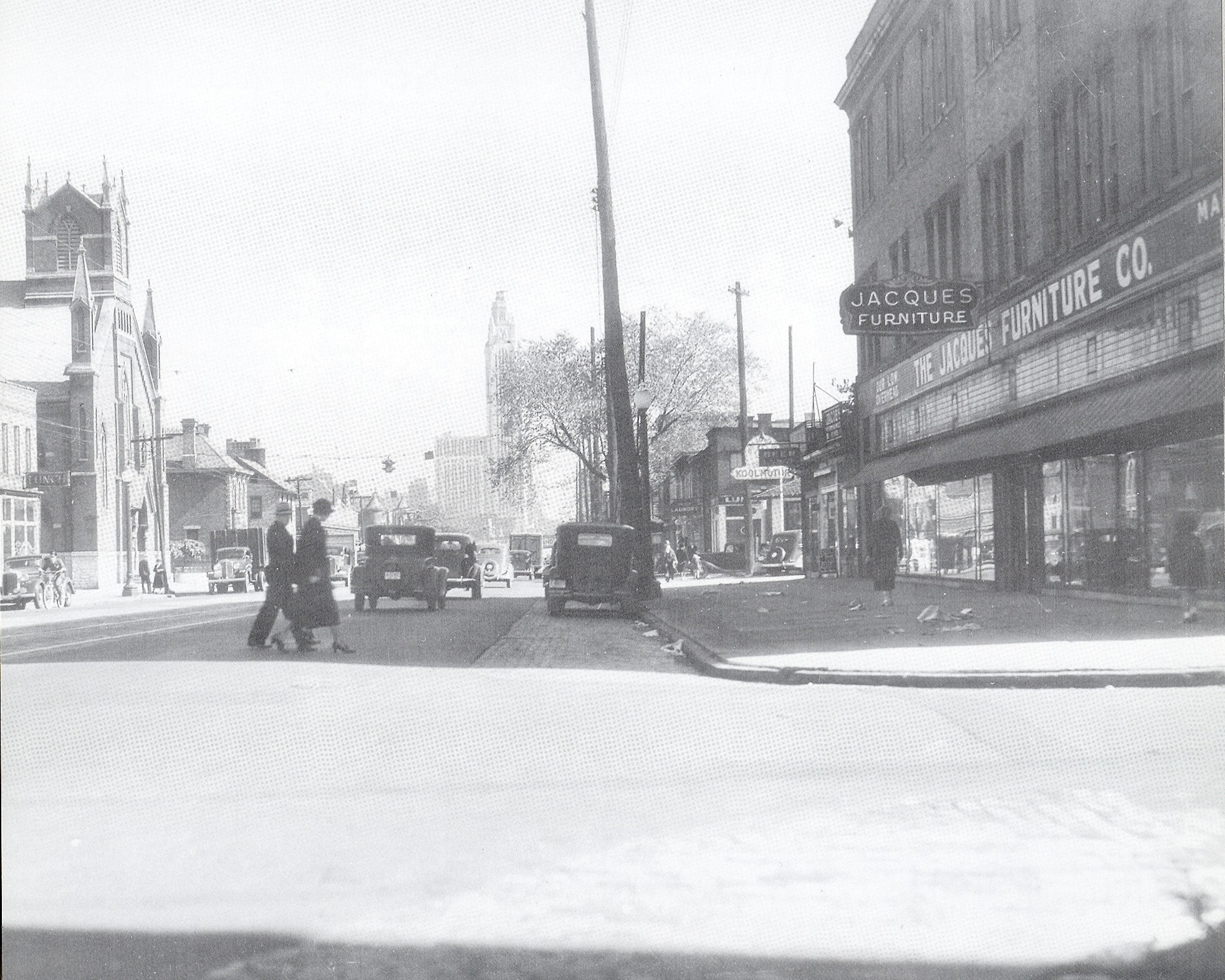
Photo Location: West Broad Street at Grubb Street, looking east. Photo Date: 1937 Photo History: Franklinton was bustling in this pre-WWII era-photo of Broad Street. It had been 24 years since the Great Flood, and the neighborhood was reaching for its historic population high along with the rest of the urban core. Unfortunately, within 2 decades, the neighborhood would be devastated by yet another flood and would be followed by 50 years of stagnation and decline.
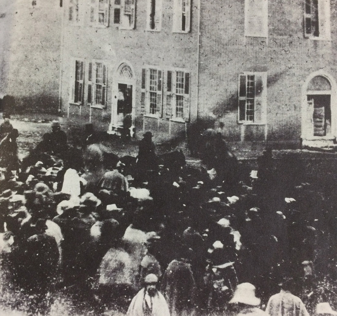
Photo Location: Broad and High Photo Date: Sometime in 1849 Photo History: Random Columbus photo 5 is one of the earliest ever known to have been taken in Columbus, and shows a group of bystanders looking at several people on horseback. The year this was taken, 1849, is significant in that it references the events taking place. 1849, of course, was the year that gold was discovered in California. The men on horseback are 49-ers, getting ready to depart Columbus to join the great California Gold Rush, and the crowd was gathered to see them off.
Click on the image for a better look.
Unfortunately, not much else is known about the photo, who the people were, or in what direction the photo was even taken.
The Random Columbus Photos 4 edition takes a look back at Downtown in the 1980s.
Date Photo Taken: 1989 Photo Location: Looking west on Broad Street from LeVeque Tower. This photo is interesting for a few reasons. First, it shows the beginning of construction to replace the Broad Street Bridge over the Scioto River. After the Great Flood of 1913 destroyed an earlier Broad Street Bridge, the one in the photo was finished in 1921. By the early 1980s, the bridge was rapidly deteriorating and the decision was made to replace it. It’s reconstruction start, however, was delayed until 1988 due to a contract to keep the Columbus 500 auto race going, which used the bridge. The nearly identical new bridge was completed in 1992 at a cost of $13.2 million. Across the bridge is the Scioto Peninsula. On the right is Vets Memorial, built in the 1950s and recently demolished to make way for a new memorial and museum as part of the redevelopment of the peninsula. On the left is the old Central High School, years before it was converted into COSI’s new location. Also of note are warehouse and other buildings that still existed on the peninsula, remnants of when this area was largely manufacturing. These were mostly demolished in the 1990s and early 2000s and were left as vacant lots for well over a decade, some of them becoming parking lots for COSI. These lots will soon become part of a large mixed-use development and park.
Believe it or not, 32 years ago and long before the urban revival began in earnest, a paid study of High Street in 1984 by a Barton-Aschman Associates of Washington, DC, made the ahead-of-its-time suggestion of a High Street road diet through Downtown. High Street had been studied over and over again since 1972 in order to figure out how to reduce traffic, but this was the most radical one to come out of them all- at least until 2010.
When the 1984 study was released, it contained the following suggestions: -Reducing High from 6 lanes to 4. -Restricting traffic to buses, taxis and emergency vehicles Monday-Friday from 7am-6:30PM. -Rebuilding the street to include pedestrian/bike friendly infrastructure and new landscaping. -A new transit mall. The changes would’ve included 11 blocks between Fulton Street and Nationwide Boulevard.
Inexplicably, the $25 million plan was endorsed by just about everyone at first, from the City of Columbus, COTA, local business owners, the Chamber of Commerce and other community leaders. There was even funding for it, through a mix from COTA and the US Urban Mass Transit Association. The plan was hailed as transformative and was thought to be a plan to create a “world-class” street. At the time, very few cities had done anything like this.
But then what always seems to happen in Columbus… happened again. Slowly, opposition built up. First, city leaders didn’t really like the 30-year commitment required for the transit mall. Then Les Wexner, a prominent and very influential member of the Chamber of Commerce at the time, publicly spoke out against the plan, which gradually convinced more and more to oppose it. It seems no shock that Wexner was opposed to such a forward-thinking urban plan considering that his dream community he would be primarily responsible for exploding- New Albany- largely eschews such concepts even to this day. The final nail however may have been the departure of James Reading, who was the general manager of COTA at the time. Reading would accept a job in Santa Clara, California, and since he was considered the “glue” that held the project together, things fell apart thereafter. Reading’s departure would have a much more widespread impact on Columbus’ transit future than just the High Street project, as he had also been a big proponent of rail transit. Early-mid 1980s proposals to bring rail to the city also largely died after he left, as his replacement shared little to none of Reading’s vision. Instead, his replacement, Richard Simonetta, largely focused on getting COTA’s bus service out of the red instead of spending time and energy on potential transit expansion. It’s hard to speculate what could’ve been, but there is a distinct possibility that High Street and transit would be very different in Columbus had Reading stayed in the city. Santa Clara today has more than 80 bus lines, 3 light rail lines and is building a dedicated-lane BRT system.
In any case, the Chamber of Commerce officially pulled support for the High project in July 1985. No alternative plan existed at the time, and for the next few years the city struggled to come up with something else with little to show for it. Ultimately, High Street pretty much stayed as it was. It was not until 2010 that the road diet idea would show up again, but this was focused more for Broad Street than High. The diet plan was officially adopted in 2012, but as of this writing, there has been no movement on the project.
Next up on the easy reposts is this Google Map I made on how I would redevelop the Westland Mall site. It was recently announced that Westland Mall will very likely be torn down sometime later this year, but the current owners have not yet given any details on a potential redevelopment plan. Here is the article about Westland’s imminent doom.
What I would like to see go into this huge site is a new neighborhood that employs a lot of urban-style characteristics. That means low to mid-rise mixed-use buildings that surround a large urban park. The buildings would contain ground floor retail with residential above. Offices, markets and hotel space would also be included in the new neighborhood. The buildings would front both West Broad and Georgesville Road. New multi-use paths would connect this development to existing paths on Georgesville and to the miles-long Camp Chase Trail along the railroad tracks near Sullivant and Georgesville. The main central park would have playground space, a ball field or two, and perhaps even a small pond. Bike lanes would go throughout, along with wide sidewalks for potential restaurant and retail patio space. Basically, this would be like the West Side’s version of the Bridge Park development in Dublin. Read more about that project here. This would end up being a hugely transformative project for the West Side in a way that the new casino never could be. I suspect, however, that the developer will go with some kind of single-story, single-use big box retail concept like a Walmart, along with fast food outlets near West Broad. Hopefully, that is not the case and they are more forward thinking.
So here is the map I made on the general idea of what I think should happen: