Random Columbus photos 1 is the first edition in a new, very occasional series highlighting historic views in and around the city.
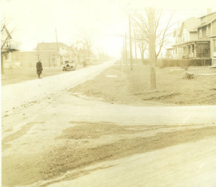
Photo Date: January 15, 1936 Location: Parkwood Avenue, East Linden
This random street scene photo was taken during the frigid winter of 1935-36. I couldn’t pinpoint exactly where the photo was taken, only that the style of homes indicates that it was taken looking north between Earl and Denune Avenues. Little has changed on Parkwood in the last 79 years. The area still looks and feels a little rural, and there are still no sidewalks. The one change, however, is that the roads are no longer dirt.
The day of the photo was fairly mild, with highs in the mid-40s. The next day, however, a snowstorm struck that dropped about 5″ of snow, and just a week later, temperatures hit 16 degrees below zero.
After a generally cold December, the January 1879 arctic outbreak would begin the new year, leading to Columbus’ 2nd coldest temperature ever officially recorded. The outbreak began on January 2nd, when a strong cold front moved in from the northwest in the early afternoon hours. The temperature fell rapidly during the evening, reaching a low of -13 on the 2nd for a total drop that day of 42 degrees. The core of the cold air moved across Ohio during the day of the 3rd, so temperatures warmed very little. Highs across the state were in the single digits south to below zero across the norther 2/3rds. Columbus had a rare below zero high of -4, which is the 2nd coldest January high on record and the 3rd coldest high of any month. The low on the 3rd was a frigid -20. This low stood as the coldest temperature in Columbus for 115 years, only being surpassed during the great arctic outbreak of January 1994, during which the temperature fell to -22.
The strong front was very moisture starved, and only a few tenths to an inch to an inch of snow fell with its passage.
Temperatures remained in the single digits for two more days before a gradual warming commenced. By the 8th temperatures went above freezing. The rest of January 1879 was fairly tame. 16 days after the 8th had highs of 35 or greater.
Of note is that the temperature of -20 occurred two more times before the end of the 19th century, in January 1884 and February 1899.
This kind of post seems obligatory at this time of year. I thought about making just one big post, but there was so much that happened this year that I decided to break it up by month. This won’t include every single piece of news, of course, but rather just the highlights. First up is the January 2014 review.
Weather January 2014 continued what December 2013 had started. Snowfall was nearly 2x above normal and temperatures were almost 7 degrees below normal. The month tied for the 15th coldest January and the 16th snowiest. The coldest low was -11 and the low hit 0 or below 7 times, the most since 1994. The biggest snow event occurred on the 25th-26th with 8.3″. This was the 10th largest January snowstorm of all time. Snow depth reached at least 1″ on 19 days.
A severe 1913 hailstorm hit parts of the South Side on that Wednesday afternoon. In an issue of The Democratic Banner out of Mt. Vernon, the headline on July 11th read “Streets Covered with Ice Boulders: Destruction Wrought by Hail Storm at Columbus.”
The article went on: This city was visited by probably the most disastrous hailstorm in its history. The damage to crops and buildings in this immediate vicinity is estimated conservatively at $125,000. (About $3.1 million today). South Side florists alone report losses of approximately $50,000. In hundreds of houses practically every window was broken. The ground on the South Side was covered by a thick layer of “ice boulders” for an hour or two afterwards. As a midsummer phenomenon it probably was without a parallel in this state.
Accompanied by 45 mph winds, the hail that fell was reported to be about 3″ in diameter. The hail was large enough to hit and fracture the wrist of J.W. Sprouse, a teamster, and shattered glass from a greenhouse was driven through the arm of William Bernard, a florist.
For a good portion of the US, the winter of 2013-2014 was one of the worst, if not the worst, in recent memory. Cold and snow hit early in the season and didn’t let up until the first half of March. Now that April is behind us (the last month that snow typically might fall during a season), we can take a look back at the Winter 2013-2014 Review.
A Look Back at Snowfall For many in Central Ohio, winter provided its first taste on October 23rd, when a cold front briefly changed rain to a wet snow that coated car tops. This was merely a prelude to what would come.
2013-14 Winter Snowfall vs. Normal
November Notable Snow Events November 11-12th, 2013: This was the first real accumulating snowfall of the season, dropping a general 1″-2″ across the area. The highest total in Franklin County was 2″ reported just southeast of Clintonville. A map of the event can be found here.
November 26th-27th, 2013: The months 2nd and larger event occurred towards the end of the month, and dropped 1″-4″ across the county, with the higher totals on the east side of Columbus. A map of the event can be found here. The November total of 4.7″, while not anywhere near record breaking, was a top 20 snowiest, coming in at #14. November 2013 was also the snowiest Columbus had seen since 1972, when 6.3″ fell.
December Notable Snow Events December 6th, 2013: This was the first major event of the season. A low pressure center brought rain to the area on the 5th. As temperatures cooled, rain gradually changed to freezing rain and then heavy snow, dropping 3″-6″ across the area. A map of this event can be found here.
December 10th, 2013: The second event of the month was a persistent band of snow that set up alon I-71. The cold air produced high ratios, dropping 1″-3″. http://www.erh.noaa.gov/iln/events/20131210/
December 14th, 2013: Rain changed to snow along and north of I-71. http://www.erh.noaa.gov/iln/events/20131214/ December’s 12.7″ total was 2 1/2x normal, and the first 10 days of the month were the snowiest on record. It also made the month the 8th snowiest December on record. Further, it was the 2nd consecutive above average December and the 5th since 2007 to be so.
January Notable Snow Events January 2nd, 2014: The new year started off as snowy as the previous ended, when a low pressure brought occasionally heavy snow and 3″-5″ across the city. http://www.erh.noaa.gov/iln/events/20140102/
January 25th-26th, 2014: The months’ signature event, a strong storm brough a mixed bag of precipitation, including heavy snow to parts of the city. As the storm passed, additional snow squalls developed into the 26th and brought occasional whiteout conditions. Columbus’ official 2-day total was 8.3″. A map of the event can be found here, though it only lists totals for the 25th:
All told, the 17.7″ of snow for the month was the 16th snowiest on record, and the 8.3″ snow event tied for the 10th largest January event since records began.
February Notable Snow Events February 4th-5th, 2014: A low pressure brought heavy snow and mixed precipitation to the area, and proved to be winter’s largest snow event with 6″-10″ across the city. The 10.6″ at Columbus was the largest storm of the winter, tied as the 3rd largest February snowstorm, and provided the 7th largest daily February snowfall. http://www.erh.noaa.gov/iln/events/20140205/
February 14th-15th, 2014: Valentines Day brought a storm that skimmed the area with 2″-4″, with much higher totals to the south. http://www.erh.noaa.gov/iln/events/20140215/ February’s 15.9″ of snow was the 6th snowiest on record.
March did not break any records or have any large events, but it was more or less a capping month to a winter that kept snowing.
April saw just one snow event, on the 15th, when half an inch to 1″ fell, ending the snowfall season.
So ultimately, 2013-2014’s 56.4″ of snow ranks it as the 3rd snowiest winter since records began in 1878. It was also the #1 snowiest meteorological winter (December-February) on record. The graph below shows the top 10 snowiest winters. Notice that 4 of the 10 have occurred since 2002, with 3 since 2007. Are we possibly entering a snowier period? That remains to be seen.