
Ever wonder how Columbus got so big in area? Its city limits stretch into parts of other counties and include about a third of Franklin County. Today, it has a reputation for annexing its way to growth, but how true is this?
Well, 50 years ago, it was more or less true. Today, not so much. Aggressive annexation began in Columbus in 1953, when Mayor Maynard “Jack” Sensenbrenner began his policy of requiring annexation into the city if communities wanted city water service. Between 1953 and 1960, the area size of the city more than doubled, and that rate continued through the 1960s and 1970s, even after Sensenbrenner was no longer mayor. After 1980, annexation rates gradually began to decline.
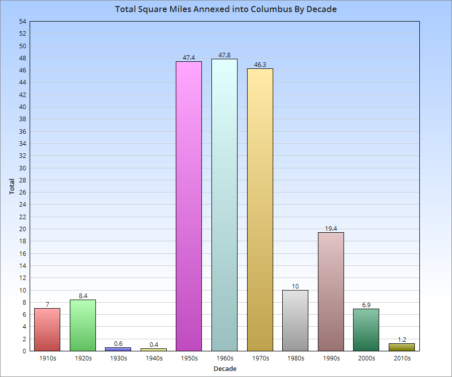
As the chart above shows, you can see the rapid rate of growth during the 1950s-1970s and the decline in more recent decades. Through the first 5 years of the 2010s, Columbus is on pace to add fewer than 3 square miles by 2020. Despite that fact, the city’s annual population growth since 2010 is exceeding the average annual growth of any decade during the mass annexation years. This strongly supports that the dynamic, and indeed, the story of Columbus’ growth is no longer about “fake” growth through the addition of existing land and population, but rather though the influx of new residents from outside of the city limits altogether. This is helping to gradually raise the city’s population density, which exceeded Cincinnati’s last year, as the chart below shows, along with a few other Columbus peers.