Before and After April 2017


**Note: Some photos have been updated for 2018.

I haven’t done a Before and After installment for a while. This time around, I chose to not focus on any single neighborhood.

First up is a photo of the construction of the Columbus Interurban Terminal, looking northwest from 3rd. The photo was taken on October 5, 1911, about 3 months before the building opened. The interurban system was relatively short-lived in the city, and the terminal closed after only 26 years in 1938. The building survived as a grocery store through the mid-1960s before the building was demolished in 1967 as part of the construction of the Greyhound Bus Terminal across the street. The actual location of the building was not on the Greyhound site, but was used as an overflow parking lot. It remained a parking lot until the mid-1980s, when it became part of the City Centre Mall site. Today, plans are for the site to become the location for the 12-story, 80 on the Commons mixed-use project.

Before and after April 2017

October, 1911.

Here is the same place in October, 2018.

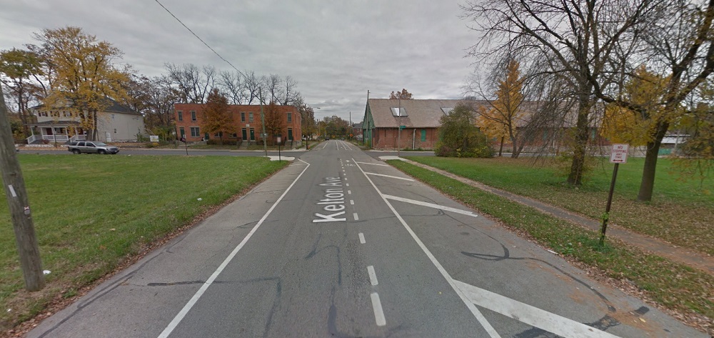
The second historic photo is of the #57 streetcar on Kelton Avenue just south of the Oak Street intersection. The photo, which looks north, was taken on June 30, 1915 and includes 3 separate visible buildings as well. The house on the left actually survived until 1977, when it and the rest of the east half of the block was demolished. The building visible on the right is the surviving streetcar barn. Today, it is in bad shape, and while many would like to see it renovated and saved, time seems to be running out. The other surviving building, barely visible in the 1915 photo, is the tenement building on the northwest corner of Oak and Kelton.
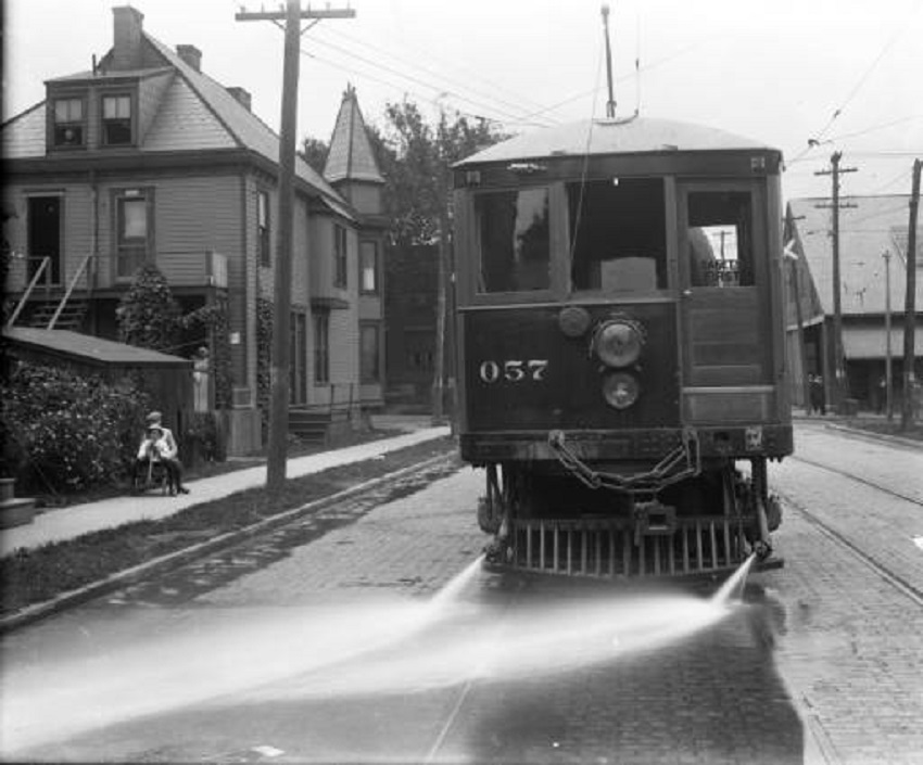
And in 2015:

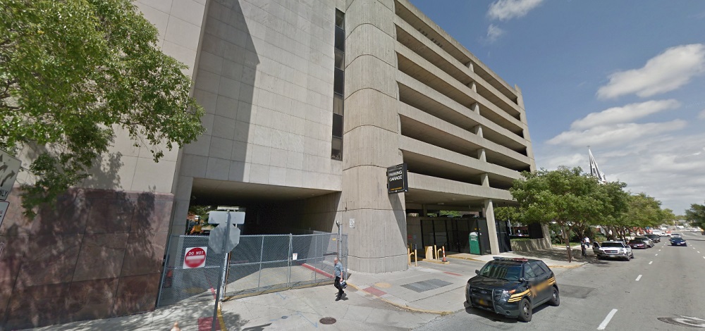
Third in this list is a photo of the demolition of the old Franklin County Jail, once located at 36 E. Fulton Street in Downtown. Built in 1889, the structure survived until the fall of 1971, when the building, which by then had become outdated for its intended purpose, was torn down to make way for- what else- a parking garage. The parking garage remains to the present day. Columbus leaders at the time should’ve been flogged for such short-sighted thinking, something that was repeated over and over and over again during that era. Today, such a very cool, unique building would’ve made an excellent candidate for mixed-use conversion.

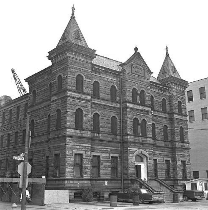
And in August, 2016:

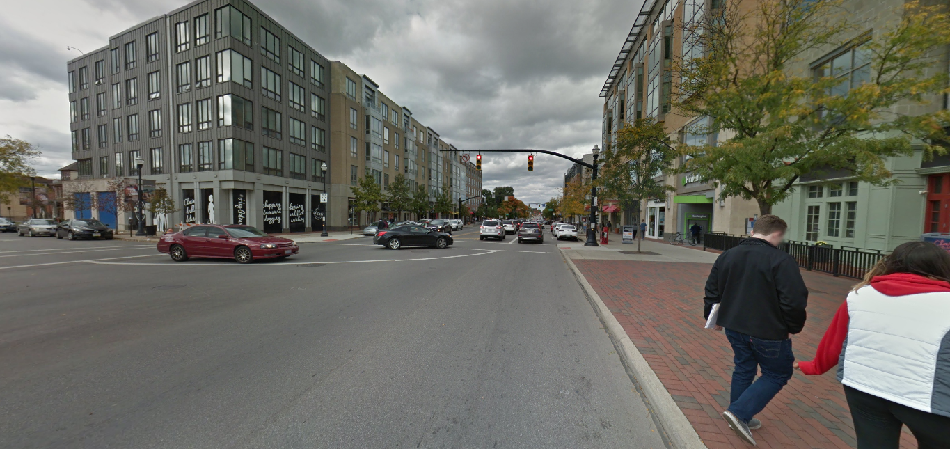
Finally, this next photo isn’t really historic. It was taken a mere 15 years ago in February, 2002, looking northwest from the corner of N. High Street and 10th Avenue. At the time, this area had been made up of low-rise historic buildings that had long held bars for OSU students. All these buildings in the photo, and many more, were demolished not long after the photo was taken in order to make room for the South Campus Gateway, now more or less just called the Gateway. Similar large-scale demolitions are taking place to the north and south as the entirety of the High Street corridor around Campus is transformed. Whether that is good or bad depends on who you ask. What can be agreed upon, however, is that the corridor will be almost unrecognizable in the end.

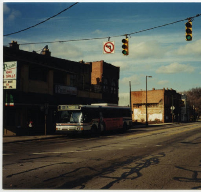
And in October, 2016:


Random Columbus Photos 4


The Random Columbus Photos 4 edition takes a look back at Downtown in the 1980s.

Date Photo Taken: 1989
Photo Location: Looking west on Broad Street from LeVeque Tower.
Random Columbus photos 4
This photo is interesting for a few reasons. First, it shows the beginning of construction to replace the Broad Street Bridge over the Scioto River. After the Great Flood of 1913 destroyed an earlier Broad Street Bridge, the one in the photo was finished in 1921. By the early 1980s, the bridge was rapidly deteriorating and the decision was made to replace it. It’s reconstruction start, however, was delayed until 1988 due to a contract to keep the Columbus 500 auto race going, which used the bridge. The nearly identical new bridge was completed in 1992 at a cost of $13.2 million.
Across the bridge is the Scioto Peninsula. On the right is Vets Memorial, built in the 1950s and recently demolished to make way for a new memorial and museum as part of the redevelopment of the peninsula. On the left is the old Central High School, years before it was converted into COSI’s new location. Also of note are warehouse and other buildings that still existed on the peninsula, remnants of when this area was largely manufacturing. These were mostly demolished in the 1990s and early 2000s and were left as vacant lots for well over a decade, some of them becoming parking lots for COSI. These lots will soon become part of a large mixed-use development and park.

Failed Project The 1985 High Street Road Diet


Believe it or not, 32 years ago and long before the urban revival began in earnest, a paid study of High Street in 1984 by a Barton-Aschman Associates of Washington, DC, made the ahead-of-its-time suggestion of a High Street road diet through Downtown. High Street had been studied over and over again since 1972 in order to figure out how to reduce traffic, but this was the most radical one to come out of them all- at least until 2010.

When the 1984 study was released, it contained the following suggestions:
-Reducing High from 6 lanes to 4.
-Restricting traffic to buses, taxis and emergency vehicles Monday-Friday from 7am-6:30PM.
-Rebuilding the street to include pedestrian/bike friendly infrastructure and new landscaping.
-A new transit mall.
The changes would’ve included 11 blocks between Fulton Street and Nationwide Boulevard.

Inexplicably, the $25 million plan was endorsed by just about everyone at first, from the City of Columbus, COTA, local business owners, the Chamber of Commerce and other community leaders. There was even funding for it, through a mix from COTA and the US Urban Mass Transit Association. The plan was hailed as transformative and was thought to be a plan to create a “world-class” street. At the time, very few cities had done anything like this.

But then what always seems to happen in Columbus… happened again. Slowly, opposition built up. First, city leaders didn’t really like the 30-year commitment required for the transit mall. Then Les Wexner, a prominent and very influential member of the Chamber of Commerce at the time, publicly spoke out against the plan, which gradually convinced more and more to oppose it. It seems no shock that Wexner was opposed to such a forward-thinking urban plan considering that his dream community he would be primarily responsible for exploding- New Albany- largely eschews such concepts even to this day. The final nail however may have been the departure of James Reading, who was the general manager of COTA at the time. Reading would accept a job in Santa Clara, California, and since he was considered the “glue” that held the project together, things fell apart thereafter. Reading’s departure would have a much more widespread impact on Columbus’ transit future than just the High Street project, as he had also been a big proponent of rail transit. Early-mid 1980s proposals to bring rail to the city also largely died after he left, as his replacement shared little to none of Reading’s vision. Instead, his replacement, Richard Simonetta, largely focused on getting COTA’s bus service out of the red instead of spending time and energy on potential transit expansion. It’s hard to speculate what could’ve been, but there is a distinct possibility that High Street and transit would be very different in Columbus had Reading stayed in the city. Santa Clara today has more than 80 bus lines, 3 light rail lines and is building a dedicated-lane BRT system.

In any case, the Chamber of Commerce officially pulled support for the High project in July 1985. No alternative plan existed at the time, and for the next few years the city struggled to come up with something else with little to show for it. Ultimately, High Street pretty much stayed as it was. It was not until 2010 that the road diet idea would show up again, but this was focused more for Broad Street than High. The diet plan was officially adopted in 2012, but as of this writing, there has been no movement on the project.

High Street road diet

The Broad Street road diet rendering from 2010.


Columbus’ Shrinking Annexation Rate

Ever wonder how Columbus got so big in area? Its city limits stretch into parts of other counties and include about a third of Franklin County. Today, it has a reputation for annexing its way to growth, but how true is this?

Well, 50 years ago, it was more or less true. Today, not so much. Aggressive annexation began in Columbus in 1953, when Mayor Maynard “Jack” Sensenbrenner began his policy of requiring annexation into the city if communities wanted city water service. Between 1953 and 1960, the area size of the city more than doubled, and that rate continued through the 1960s and 1970s, even after Sensenbrenner was no longer mayor. After 1980, annexation rates gradually began to decline.

As the chart above shows, you can see the rapid rate of growth during the 1950s-1970s and the decline in more recent decades. Through the first 5 years of the 2010s, Columbus is on pace to add fewer than 3 square miles by 2020. Despite that fact, the city’s annual population growth since 2010 is exceeding the average annual growth of any decade during the mass annexation years. This strongly supports that the dynamic, and indeed, the story of Columbus’ growth is no longer about “fake” growth through the addition of existing land and population, but rather though the influx of new residents from outside of the city limits altogether. This is helping to gradually raise the city’s population density, which exceeded Cincinnati’s last year, as the chart below shows, along with a few other Columbus peers.


How I Would Redevelop the Westland Mall Site


Westland mall site

The desolate view of the former Westland Mall.

Next up on the easy reposts is this Google Map I made on how I would redevelop the Westland Mall site. It was recently announced that Westland Mall will very likely be torn down sometime later this year, but the current owners have not yet given any details on a potential redevelopment plan. Here is the article about Westland’s imminent doom.

What I would like to see go into this huge site is a new neighborhood that employs a lot of urban-style characteristics. That means low to mid-rise mixed-use buildings that surround a large urban park. The buildings would contain ground floor retail with residential above. Offices, markets and hotel space would also be included in the new neighborhood. The buildings would front both West Broad and Georgesville Road. New multi-use paths would connect this development to existing paths on Georgesville and to the miles-long Camp Chase Trail along the railroad tracks near Sullivant and Georgesville. The main central park would have playground space, a ball field or two, and perhaps even a small pond. Bike lanes would go throughout, along with wide sidewalks for potential restaurant and retail patio space. Basically, this would be like the West Side’s version of the Bridge Park development in Dublin. Read more about that project here.
This would end up being a hugely transformative project for the West Side in a way that the new casino never could be. I suspect, however, that the developer will go with some kind of single-story, single-use big box retail concept like a Walmart, along with fast food outlets near West Broad. Hopefully, that is not the case and they are more forward thinking.

So here is the map I made on the general idea of what I think should happen: