2015 County Population Estimates Report


The US Census has released its population estimates for both counties and metros for the year ending July 1, 2015. Here is a detailed look at Ohio’s counties in this 2015 county population estimates report.

Ohio’s Top 25 Largest Counties
2010……………………………….2014………………………………..2015

1. Cuyahoga: 1,280,109….1. Cuyahoga: 1,263,796……1. Cuyahoga: 1,255,921
2. Franklin: 1,163,545……..2. Franklin: 1,234,126………2. Franklin: 1,251,722
3. Hamilton: 802,270……….3. Hamilton: 806,332……….3. Hamilton: 807,598
4. Summit: 541,671………..4. Summit: 542,600………….4. Summit: 541,968
5. Montgomery: 536,216….5. Montgomery: 532,515…..5. Montgomery: 532,258
6. Lucas: 441,575…………..6. Lucas: 434,615…………….6. Lucas: 433,689
7. Stark: 375,461…………….7. Stark: 375,638…………….7. Butler: 376,353
8. Butler: 369,064…………..8. Butler: 373,948…………….8. Stark: 375,165
9. Lorain: 301,471…………..9. Lorain: 304,187……………9. Lorain:305,147
10. Mahoning: 238,398……10. Mahoning: 233,398…….10. Mahoning: 231,900
11. Lake: 230,004…………..11. Lake: 229,220……………11. Lake: 229,245
12. Warren: 213,524………..12. Warren: 221,816………..12. Warren: 224,469
13. Trumbull: 209,854………13. Trumbull: 205,255……..13. Trumbull: 203,751
14. Clermont: 197,795……..14. Clermont: 201,375……..14. Clermont: 201,973
15. Delaware: 175,146……..15. Delaware: 189,237…….15. Delaware: 193,0134
16. Medina: 172,542………..16. Medina: 175,963………..16. Medina: 176,395
17. Licking: 166,480…………17. Licking: 169,407………..17. Licking: 170,570
18. Greene: 161,608………..18. Greene: 164,660………..18. Greene: 164,427
19. Portage: 161,448……….19. Portage: 162,235………..19. Porage: 162,275
20. Fairfield: 146,385……….20. Fairfield: 150,432………..20. Fairfield: 151,408
21. Clark: 148,246…………..21. Clark: 136,482……………21. Clark: 135,959
22. Wood: 125,940………….22. Wood: 129,575…………..22. Wood: 129,730
23. Richland: 124,173……..23. Richland: 121,914……….23. Richland: 121,707
24. Wayne: 114,439………..24. Wayne: 115,572………….24. Wayne: 116,063
25. Columbiana: 107,863…25. Columbiana: 105,597…..25. Columbiana: 104,806

From the numbers above, Columbus’ Franklin County was just below Cuyahoga last year. It is likely that, given each county’s growth rates, Franklin has now passed up Cuyahoga to become Ohio’s most populated county.

Top 25 Total Growth Counties 2010-2015
1. Franklin: +88,177
2. Delaware: +18,824
3. Warren: +11,601
4. Butler: +8,223
5. Fairfield: +5,256
6. Hamilton: +5,224
7. Clermont: +4,610
8. Wood: +4,242
9. Licking: +4,090
10. Medina: +4,062
11. Lorain: +3,791
12. Greene: +2,858
13. Union: +2,010
14. Miami: +1,718
15. Wayne: +1,549
16. Holmes: +1,543
17. Pickaway: +1,300
18. Athens: +1,113
19. Portage: +854
20. Hancock: +791
21. Geauga: +692
22. Madison: +664
23. Tuscarawas: +334
24. Morrow: +247
25. Muskingum: +216
2015 county population estimates report

Components of County Population Change

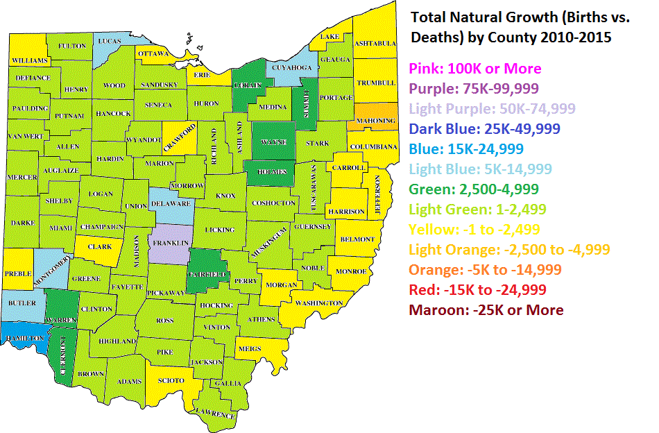
Top 25 Counties for Natural Growth (Births vs. Deaths) 2010-2015
1. Franklin: +50,736
2. Hamilton: +17,256
3. Butler: +7,785
4. Cuyahoga: +7,409
5. Lucas: +7,053
6. Delaware: +6,260
7. Montgomery: +5,007
8. Warren: +4,688
9. Clermont: +3,987
10. Summit: +3,194
11. Fairfield: +2,676
12. Lorain: +2,630
13. Holmes: +2,613
14. Wayne: +2,554
15. Licking: +2,482
16. Greene: +2,309
17. Medina: +2,040
18. Wood: +1,824
19. Union: +1,475
20. Hancock: +1,196
21. Allen: +1,115
22. Shelby: +1,038
23. Miami: +902
24. Putnam: +849
25. Huron: +815

Franklin County’s natural growth rate destroys every other county in the state. It gains almost 7x that of Cuyahoga County, despite Cuyahoga having a larger population during this period, and nearly 3x that of Hamilton County.

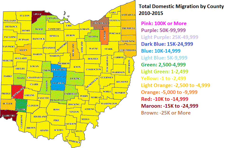
Top 25 Counties for Domestic Migration 2010-2015
1. Franklin: +11,715
2. Delaware: +10,532
3. Warren: +4,496
4. Fairfield: +1,691
5. Licking: +1,249
6. Medina: +1,234
7. Wood: +1,120
8. Pickaway: +711
9. Miami: +475
10. Union: +249
11. Madison: +246
12. Ottawa: +5
13. Clermont: -39
14. Morrow: -159
15. Morgan: -162
16. Monroe: -167
17. Washington: -177
18. Harrison: -198
19. Belmont: -221
20. Geauga: -320
21. Vinton: -361
22. Meigs: -401
23. Noble: -421
24. Van Wert: -431
25. Perry: -464

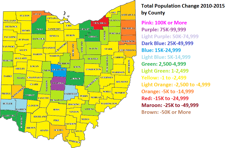
Again, Franklin County leads the pack, with Columbus metro counties performing the best statewide, as shown in the map below.

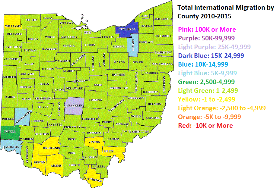
Top 25 Counties for International Migration 2010-2015
1. Franklin: +26,977
2. Cuyahoga: +16,926
3. Hamilton: +9,016
4. Montgomery: +5,380
5. Summit: +5,307
6. Butler: +4,066
7. Greene: +2,400
8. Lorain: +2,303
9. Warren: +2,198
10. Lucas: +2,194
11. Portage: +1,991
12. Delaware: +1,610
13. Athens: +1,586
14. Mahoning: +1,383
15. Wood: +1,026
16. Stark: +881
17. Lake: +729
18. Fairfield: +658
19. Clermont: +612
20. Medina: +578
21. Tuscarawas: +468
22. Wayne: +408
23. Licking: +404
24. Allen: +375
25. Miami: +359

Most Ohio counties saw increases in international migration, but once again, none came close to Franklin County’s total.

So there you have it, the updated numbers for Ohio’s counties.


2013 Census Tract Estimates


The Census released updated 2013 census tract estimates, and they showed some interesting things. There are 285 census tracts that make up Franklin County.

First, let’s take a look at the Franklin County trends 2000-2013.
2013 census tract estimates

In regards to the above map, it’s a mix of both the 2013 official estimates and some that I did. For example, the official estimates had the Downtown tracts 30 and 40 losing population, as well as most of the Short North. That’s rather absurd considering the level of residential construction in these areas, as well as population estimates the city has done in the last few years for Downtown. In fact, the 2013 official estimates have Downtown tract population BELOW 2010. That’s just not the reality. So I looked over the tracts and adjusted them according to their long-term growth/decline trends. Most of them I left alone, but some adjustments had to be made. However, I was very conservative with any changes, and several tracts that the official estimates showed gains, I actually had losses.

Here are all the tracts that grew by at least 300 people between 2010 and 2013 in Franklin County, as well as their locations.
Blacklick #7395: +1,609
Dublin #6230: +1,214
Columbus-West Side #7951: +1,002
Columbus-Northwest #6372: +966
Columbus Northeast #6931: +963
Hilliard #7921: +955
Columbus-East Side #9361: +952
Columbus-West Side #8350: +951
Columbus-Northwest: #6384: +949
Dublin #6220: +933
Columbus-West Side #8141: +921
Columbus-Easton #7551: +793
Columbus-Southeast #9373: +749
Hilliard #7933: +688
Minerva Park #7112: +675
Columbus-South Side #8340: +652
Hilliard #7954: +643
Columbus North Side #7044: +636
Columbus Northeast #7132: +615
Columbus Northwest #6396: +557
Dublin #6386: +549
Columbus North Side #6921: +540
Columbus Northwest #6393: +492
Columbus-West Side: +489
Gahanna #7492: +473
New Albany #7209: +472
Columbus-Hilltop #8321: +466
Columbus-Southeast #9374: +455
Grove City #9740: +441
Columbus Northeast #6945: +438
Hillard #7931: +432
Columbus-West Side #7812: +427
Columbus-South Side #9590: +411
Columbus-South Side #8710: +407
Hilliard #10602: +407
Columbus-South Side #8822: +403
Whitehall #9230: +398
Columbus-West Side #8163: +397
Columbus-East Side #9362: +389
Columbus-Downtown #30: +387
Hilliard #7953: +382
Columbus-West Side #6330: +371
Columbus-Northwest #6387: +361
Columbus-East Side #9322: +352
Columbus-South Side #8825: +349
Columbus-Southwest #8161: +346
West Side-Marble Cliff #43: +345
Columbus-Southwest #8370: +340
Grandview #85: +332
Columbus-Downtown #40: +321
Hilliard #7922: +320
Dublin #6371: +312
Grove City #9751: +304
Columbus-Campus Area #13: +303

As far as the core of the city, the 1950 boundaries, here are the results.

There are 78 tracts that make up the original 1950 city boundary. Using the official estimates, 38 of the 78 tracts grew between 2010-2013, yet had a total loss of 3,229. However, again, it had all the Downtown and adjacent tracts inexplicably losing population, yet the opposite is occurring in these areas. For Downtown, the combined loss was about 370, and for the Short North, it had the loss at more than 700.

Using my adjusted estimates, 35 tracts are growing, adding 1,166 people 2010-2013. Most of the gains were made in the Downtown and adjacent tracts, and some of the losses were simply not as steep. For example, the official estimates had tract #10, in the Campus area, losing nearly 1,300 people since 2010, which is a ridiculous loss, especially considering it grew by almost 8% 2000-2010. In fact, most of the largest losses from the official estimates were around Campus and the Short North. Nonsense.

2013 City Population Estimates


2013 city population estimates

Today, the Census released new population figures for cities and incorporated places. I looked at all those places within the Columbus metro area and came up with the following stats on 2013 city population estimates.

Top 25 Largest Places in the Columbus Metro, July 1, 2013
1. Columbus: 822,553
2. Newark: 47,777
3. Dublin: 43,607
4. Lancaster: 39,325
5. Westerville: 37,530
6. Grove City: 37,490
7. Reynoldsburg: 36,526
8. Delaware: 36,459
9. Upper Arlington: 34,420
10. Gahanna: 34,051
11. Hilliard: 31,012
12. Marysville: 22,396
13. Pickerington: 19,085
14. Whitehall: 18,503
15. Pataskala: 15,160
16. Worthington: 13,837
17. Bexley: 13,455
18. Circleville: 13,444
19. Powell: 12,237
20. Heath: 10,45
21. London: 9,978
22. New Albany: 8,820
23. Canal Winchester: 7,543
24. Logan: 7,146
25. Grandview Heights: 6,943

Top 25 Largest Total Change 2012-2013
1. Columbus: +12,450
2. Dublin: +710
3. Grove City: +637
4. Delaware: +534
5. Lancaster: +422
6. Hilliard: +421
7. Pickerington: +375
8. Westerville: +321
9. Marysville: +284
10. New Albany: +282
11. Powell: +258
12. Gahanna: +215
13. Upper Arlington: +183
14. Reynoldsburg: +172
15. Bexley: +163
16. Canal Winchester: +143
17. Sunbury: +109
18. London: +107
19. Pataskala: +98
20. Groveport: +88
21. Whitehall: +87
22. Worthington: +69
23. Hanover: +67
24. Heath: +63
25. Lithopolis/Obetz/West Jefferson: +35

Top 25 Largest Total Change 2010-2013
1. Columbus: +35,520
2. Hilliard: +2,577
3. Grove City: +1,915
4. Dublin: +1,856
5. Delaware: +1,706
6. Westerville: +1,410
7. New Albany: +1,096
8. Gahanna: +806
9. Pickerington: +794
10. Powell: +737
11. Upper Arlington: +649
12. Reynoldsburg: +633
13. Lancaster: +545
14. Canal Winchester: +442
15. Whitehall: +441
16. Grandview Heights: +407
17. Bexley: +388
18. Sunbury: +326
19. Marysville: +302
20. Groveport: +269
21. Worthington: +262
22. Newark: +204
23. Johnstown: +200
24. Pataskala: +198
25. Heath: +142

Top 25 Largest % Changes 2012-2013
1. Hanover: +6.74%
2. New Albany: +3.30%
3. Lithopolis: +2.93%
4. Sunbury: +2.37%
5. Powell: +2.15%
6. Shawnee Hills: +2.12%
7. Pickerington: +2.00%
8. Canal Winchester: +1.93%
9. Grove City: +1.73%
10. Dublin: +1.66%
11. Groveport: +1.59%
12. Columbus: +1.54%
13. Delaware: +1.49%
14. Hilliard: +1.38%
15. Marysville: +1.28%
16. Bexley: +1.23%
17. Lancaster and London: +1.08%
18. Midway: +0.93%
19. Harrisburg: +0.92%
20. Westerville: +0.86%
21. Brice: +0.85%
22. Kirkersville and Obetz: +0.76%
23. Milford Center: +0.75%
24. Pataskala: +0.65%
25. Gahanna and Hemlock: +0.64%

Top 25 Largest % Changes 2010-2013
1. Hanover: +15.20%
2. New Albany: +14.19%
3. Lithopolis: +11.21%
4. Hilliard: +9.06%
5. Sunbury: +7.43%
6. Powell: +6.41%
7. Grandview Heights: +6.23%
8. Canal Winchester: +6.22%
9. Shawnee Hills: +6.17%
10. Grove City: +5.38%
11. Groveport: +5.02%
12. Delaware: +4.91%
13. Columbus: +4.51%
14. Dublin: +4.45%
15. Brice: +4.39%
16. Pickerington: +4.34%
17. Johnstown: +4.32%
18. Westerville: +3.90%
19. New Holland: +3.25%
20. Bexley: +2.97%
21. Harrisburg: +2.91%
22. Obetz: +2.74%
23. Riverlea: +2.57%
24. Lockbourne: +2.53%
25. Galena: +2.45%

Trends
Average Annual Growth 2000-2010 vs. 2010-2013 for the Top 25 Largest Places
2000-2010————2010-2013——–% Change

1. Upper Arlington: +9 +216 +2,300%
2. Bexley: -15 +129 +960.0%
3. Grandview Heights: -16 +136 +950.0%
4. Westerville: +80 +470 +487.50%
5. Circleville: -17 +43 +352.94%
6. Gahanna: +61 +269 +340.98%
7. Worthington: -55 +87 +258.18%
8. Whitehall: -114 +147 +228.95%
9. Hilliard: +400 +859 +114.75%
10. Columbus: +7,556 +11,840 +56.70%
11. New Albany: +400 +365 -8.75%
12. Grove City: +850 +638 -24.94%
13. Delaware: +951 +569 -40.17%
14. Dublin: +1,036 +619 -40.25%
15. Canal Winchester: +262 +147 -43.89%
16. Reynoldsburg: +382 +211 -44.76%
17. Lancaster: +345 +182 -47.25%
18. Newark: +129 +68 -47.29%
19. Powell: +525 +246 -53.14%
20. Pickerington: +850 +265 -68.82%
21. Heath: +178 +47 -73.60%
22. London: +113 +25 -77.88%
23. Marysville: +615 +107 -82.60%
24. Pataskala: +471 +66 -85.99%
25. Logan: +45 -2 -104.44%

So by the trends, it definitely appears that most suburbs have slowed, while Columbus and its inner suburbs increased. This seems like a pretty good indication of the ongoing urban movement to me.


2013 Ohio County Population Estimates


Along with the metro estimates, the latest 2013 Ohio county population estimates were released on Thursday by the US Census.

Here are the statewide county maps for recent estimate years as well as previous decades, just to show how growth patterns have been changing.
2013 Ohio county population estimates


Top 10 Largest Counties
1. Cuyahoga: 1,263,154
2. Franklin: 1,212,263
3. Hamilton: 804,520
4. Summit: 541,824
5. Montgomery: 535,846
6. Lucas: 436,393
7. Stark: 375,432
8. Butler: 371,272
9. Lorain: 302,827
10. Mahoning: 233,869

Top 10 Counties with the Largest Numerical Change 2012-2013
1. Franklin: +16,193
2. Delaware: +3,791
3. Hamilton: +2,004
4. Warren: +1,859
5. Fairfield: +1,358
6. Lorain: +1,230
7. Medina: +1,190
8. Clermont: +1,190
9. Summit: +718
10. Licking: +660