Strange Columbus The Wow Signal


Strange Columbus The Wow Signal Columbus, Ohio

No, we’re not talking about being able to get HBO from the modern cable company. This signal had even worse consistency.
On August 15, 1977, the Big Ear telescope– officially known as the Ohio State University Radio Observatory- recorded a surprisingly strong signal of non-terrestrial origin. At the time, the telescope was being utilized to search for signs of extraterrestrial life, a task that many large installations around the world had been occasionally involved in, with very little to show for the effort.

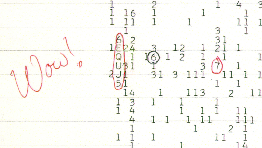
The observatory, located of of US 23 between Columbus and Delaware, had been working with SETI (Search for Extraterrestrial Intelligence) since 1973, after the installation had been deemed “defunct”. Equipment listening for frequencies would print out results on long sheets of paper, and while reviewing the data, the signal was first detected by astronomer Jerry Ehman at around 10:16PM. The readout featured the sequence 6EQEJ5, a combination that indicated frequency and signal intensity. The signal’s intensity was 30 standard deviations above normal background noise, and lasted for the full 72 seconds that the Big Ear was able to listen. Both the length and strength fell in line with expectations of what an alien signal would be like. Ehman was so shocked by it, that he circled the sequence and marked it with a “Wow!”, which is how the signal got its name.

The exact origin of the signal is even today unknown, but it was narrowed down to somewhere in the Sagittarius Constellation. Despite multiple attempts by the team at Big Ear, as well other other Earth-bound observatories to locate the signal again, they were unable to. This lack of repetition has meant that theories to its origin- either natural or otherwise- remain unconfirmed. Ehman himself was later skeptical of it actually coming from space and suggested it was signal from Earth that just happened to bounce off a satellite of some kind, but subsequent studies suggested this was highly unlikely.

For the next few decades, astronomers made multiple attempts to locate the signal again, but it was never heard again. To date, it remains one of the most mysterious space signals ever captured.

In 1997, the Big Ear ended all operations after 40 years of use. The following year, it was demolished to expand a golf course.


Strange Columbus August 1, 1949 UFO


Strange Columbus August 1, 1949 UFO Columbus, Ohio

From the files of Project Blue Book, this event involved two objects- a “smoke” trail and a bright light.


To view more incidents around the world, visit this link.
UFO Database


Before and After Iuka Ravine


Iuka Ravine, much like Glen Echo Ravine to its north, is a hidden gem in the heart of the city. Columbus isn’t exactly known for its interesting topography, so such features offer welcome variety from the otherwise endless flatness of Central Ohio. That the feature sits in the middle of the Campus area makes it even more special.

Iuka Ravine was named by Robert Neil when he returned home from the Civil War and built a home along it. Neil gave names to many local streets in the area, all based on his time in the Union Army and the places he had visited. He named the ravine after the Battle of Iuka, and Indianola Avenue was named after the location of that battle, Indianola, Mississippi.

The ravine went largely untouched until the early part of the 20th Century. Large homes sprung up along its edges beginning in the early 1900s, built to take advantage of the natural scenery. Iuka Avenue seems to have been built around 1905 given references for it don’t appear in any media before then. In 1912, Iuka Avenue was improved and the viaducts were built over the ravine at Indianola and Summit.

Before
before and after Iuka Ravine Columbus, Ohio
The before photo shows the Indianola viaduct over Iuka Avenue in 1916. Strangely enough, the ravine appears rather treeless, most likely due to construction of the viaducts and improvements 4 years prior to the time of the photo. A large building behind the bridge to the right was home to the Chi Phi fraternity at 2000 Indianola Avenue.

After

In the 2020 image, Iuka Ravine is now filled with trees- and, unfortunately, many cars- but otherwise remains remarkably untouched. Even the old Chi Phi house can still be seen peeking above the viaduct.

Over the years, Iuka has been threatened by development, but is now on the National Register of Historic Places. This popular running road and adjacent Iuka Park will likely continue to offer a bit of nature in the growing city for generations to come.

The Battle of Iuka was not a huge battle overall in comparison to other Civil War events, but over 400 soldiers still lost their lives during the fighting.


Today in History: The First Columbus Gay Pride


Depending on the source, the first official Columbus Gay Pride event was held in either June 1981 or June 1982. Going through newspaper and other records, it does seem like the first official Pride Parade in Columbus occurred on June 26, 1982. There were smaller demonstrations prior to 1982, but nothing officially recognized. In the 1970s, before events became more commonplace, small marches would take place through Downtown. Some participants of those early events would wear bags over their heads so that they would not be recognized. Very few protections, if any, existed for the LGBT community then, so a public outing could be very detrimental to someone’s life. In 1982, Columbus City Council passed a resolution recognizing Gay Pride Week 13 years after the Stonewall Riots, and allowed the parade to take place. The City had been somewhat of an early adoptee of LGBT equality when, in 1974, it passed an ordinance expanding housing and other public accommodation protections based on sexual orientation.

Columbus Ohio gay pride

The 1982 parade.

Between 500-1000 people showed up to Columbus’ first Pride. The group took a route from Goodale Park, down Front Street and eventually to Capitol Square for a rally. The first parade was somewhat low key compared to today’s enormous party atmosphere. Participants carried signs, sang songs and waved American flags. The now iconic rainbow flag had only existed since 1978 and was not yet in widespread use.
The parade faced surprisingly few hecklers along the route for a time in which support for LGBT equality was very much a minority position within the greater population. Some local churches organized small protest groups that shouted at the crowd to repent, but were booed down by the parade- a scene that unfortunately continues to the present day.

These brave participants helped pave the way for what is now one the largest such events in the nation and possibly the world. From less than 1000 marchers and spectators, the still-growing event now attracts in excess of half a million. Based on global statistics, this would put Columbus’ Pride in the top 25 largest in the world and around 8th in the United States.

Happy Pride!

For more information on local Pride history and events, as well as LGBT resources, visit the following:
Stonewall Columbus
LGBT Resources
LGBT Health Resources


Before and After: Downtown Aerial Photos


Aerial photos have been around for more than a century, ever since someone thought to take photos from airplanes. These photos go back to at least the 1910s, when the airplane was still very much a new technology. I thought it might be interesting to do show a few of these before and after Downtown aerial photos to give an idea of how the same areas look today.

Before

before and after downtown aerial photos

Downtown around 1923.


This photo of Downtown was likely taken sometime between 1922 and 1923. The main clue is that the old Central High School is clearly under construction on the Scioto Peninsula, but seemingly in the early phases. The school would later open in the fall of 1924.
Also in the photo is the new Scioto River floodwall under construction just a decade after the Great Flood of 1913. The buildings near and along the riverfront would eventually be demolished for this project, as well as the eventual Civic Center project that would later build the Post Office and Ohio Supreme Court building. Notice as well the lack of Columbus’ signature building- LeVeque Tower. That project would be constructed over the next few years.
After
before and after downtown aerial photos

Downtown in 2019.


Downtown has obviously changed enormously in the past century. Skyscrapers now dominate Downtown, and the highway system now cuts through many neighborhoods. The riverfront itself is also significantly nicer and less industrial looking.
Before
before and after downtown aerial photos

Photo taken in 1929.


This 1929 photo looks west over Franklinton towards Downtown. The most revealing part of this photo is how compact the developed area of Columbus really was at the time. Farm fields can be seen to the south and west of Columbus.
After
before and after downtown aerial photos

Photo taken in 2019.


In the after photo, nearly all the vacant land is gone except for park space, Greenlawn Cemetery and areas along the rivers.

Before
before and after downtown aerial photos
This photo of Capitol Square in 1919 is one of the earliest aerials of Downtown I was able to find. This photo predates all highrise construction. The city was compact, dense and dominated by brick buildings.
After
before and after downtown aerial photos
In the 2019 image, skyscrapers have now replaced many of the older buildings. While the Capitol itself a handful of other buildings remain, the density has largely been lost over the years, with parking lots where many once stood.
Before
before and after downtown aerial photos
The 1919 image shows the intersection of High and Broad Streets, arguably the very center of Columbus.
After
before and after downtown aerial photos
Aside from the 8 on the Square building, virtually everything else from 1919 is long gone.

Before
before and after downtown aerial photos
This much more modern image of Downtown and the riverfront was taken in 1980.
After
before and after downtown aerial photos
The 2019 Google Earth image from the same angle shows significant changes in 40 years. New skyscrapers and other development are obvious, but the massive changes to the riverfront itself almost make this look like a different city altogether.

What might these areas look like in another century?

Thousands of additional before and after photo sequences can be found at the Historic Building Database
General information about Downtown can be found at https://www.experiencecolumbus.com/neighborhoods/downtown/