Things Developers Say


On occasion, city leaders and developers say some absurd, ridiculous and hilariously tone-deaf comments regarding development and other urban issues in and around Columbus. And sometimes, as is the case with this example, those comments will highlight the often underwhelming results compared to the rhetoric.

15 years ago, the southeast corner of West Henderson and Reed Road was filled with a family-owned Italian restaurant called Da Vinci’s Ristorante. The restaurant had sat at the location since the mid-1970s and had become something of a local institution for the area.

For reasons that have been lost if ever reported, Da Vinci’s was closed and torn down in the spring of 2006. The family, it seems were either tired of the restaurant business, or had decided that a prominent location such as theirs could be a better money-making operation if it was redeveloped. Hence, Arlington Pointe, the current development on the site, came into being.

In a Dispatch article from that time, the developer- Ruscilli Real Estate Services- talked about the development in somewhat glowing terms.
“We wanted something that had more of a streetscape appeal,” said Ruscilli Real Estate President Tim Kelton. “There’s a lot of parking in the back and a hallway in the center. We wanted the shops and restaurants and everything very close to Henderson Road to fit into the neighborhood better.”

And what exactly did this development with lots of “streetscape appeal” look like? Yeah, it was just a standard strip center, the same kind that has been built 100,000x over across Ohio and the country, and now dominate the suburbs.
Things developers say Columbus, Ohio
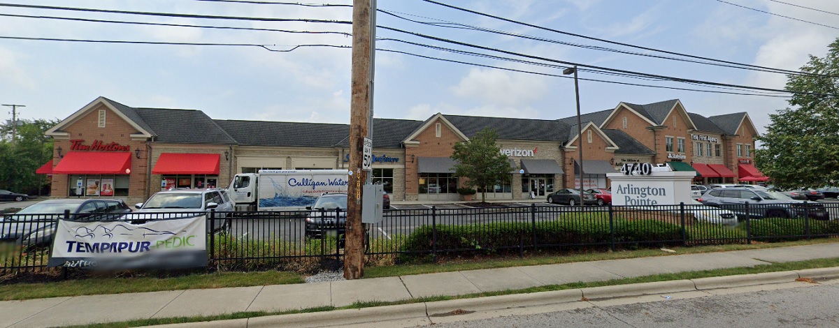
Do the shops look close to Henderson? They are set well back from Henderson, actually, and a large parking lot wraps the entire way around the building. In fact, there is more parking fronting Reed and Henderson than there is in the lot behind the building, as can be seen from the aerial.

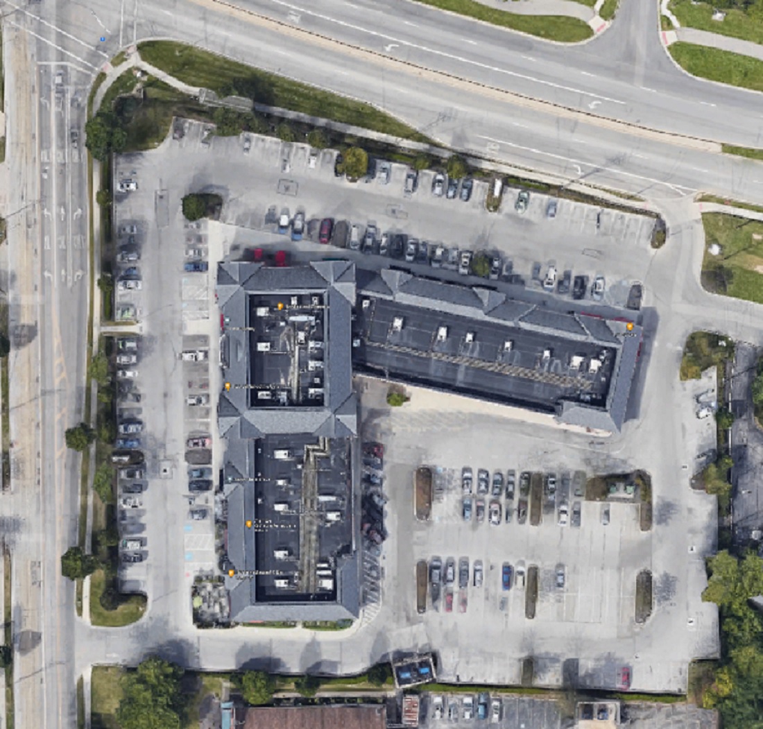
Like so many of these suburban strip centers, getting to the shops and office space by any means other than a car was completely ignored. In fact, the development caters to cars so thoroughly that it actually has its own mini-off ramp from Henderson.

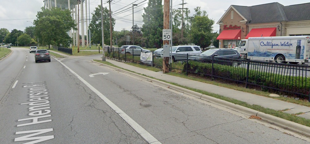
Now, there are sidewalks around, but the chances that anyone actually uses them in what must be an unpleasant, loud and dangerous walk seem slim.

Ruscilli did get one thing correct, though- the project did fit in with the area given that the vast majority of neighboring development is much the same.

You can peruse the Proposed Development for upcoming projects.


How Columbus Changed in 10 Years Part 2


how Columbus changed in 10 years part 2 Columbus, Ohio

An overcast day in 2011.

I received a massive positive response for the first version of this series, which was just a simple mashup of before and after photos of different parts of Columbus urban neighborhoods over the course of a decade. Because of that response, I have decided to do this How Columbus has changed in 10 years part 2 series. This time, besides adding more photos from core neighborhoods, I will expand the series out to other parts of the city and some suburbs, though still remaining within the 270 Outerbelt. In some ways, these before and after photos are even more drastic than the first set.

Downtown

Front Street, looking north from Main Street.
Before: 2011

After: 2021

Gay Street, looking west from Front Street.
Before: 2011

After: 2020

Gay Street, looking northeast from Normandy Avenue.
Before: 2011

After: 2021

High Street, looking north at the Convention Center.
Before: 2011

After: 2021

Nationwide Boulevard, looking north just east of Front Street.
Before: 2011

After: 2021

Nationwide Boulevard, looking east from the Olentangy River.
Before: 2011

After: 2021

Spring Street, looking northeast from Neil Avenue.
Before: 2011

After: 2020

Spruce Street, looking south from 670.
Before: 2011

After: 2021

Goodale Street, looking west from the 315 Exit.
Before: 2011

After: 2021

Short North

High Street, looking south just north of 3rd Avenue.
Before: 2009

After: 2021

Weinland Park

High Street, looking north at 7th Avenue.
Before: 2011

After: 2021

Italian Village

Detroit Avenue, looking east at Hamlet.
Before: 2009

After: 2019

4th Street, looking north from 4th Avenue.
Before: 2011

After: 2021

OSU Campus

Fred Taylor Drive, looking east at Defiance Drive.
Before: 2011

After: 2021

High Street, looking east at 15th Avenue.
Before: 2011

After: 2021

Medical Center Drive, looking north at Old Cannon Drive.
Before: 2009

After: 2021

Olentangy River Road, looking west at J Edward Weaver Memorial Drive.
Before: 2011

After: 2021

Milo-Grogan

Cleveland Avenue, looking north towards 5th Avenue.
Before: 2011

After: 2021

American Addition

Lee Avenue, looking south from 12th Avenue.
Before: 2009

After: 2019

Linden

Cleveland Avenue, looking north at Agler Road.
Before: 2011

After: 2021

Easton

Worth Avenue, looking east from Fenlon Street.
Before: 2011

After: 2021

Worth Avenue, looking east from Stelzer Road.
Before: 2011

After: 2021

Franklinton

Souder Avenue, looking west just south of I-70.
Before: 2011

After: 2021

Fifth by Northwest

Norton Avenue, looking north halfway between 3rd and 5th.
Before: 2011

After: 2020

Chesapeake Avenue, looking west.
Before: 2011

After: 2020

King-Lincoln

Long Street, looking west at I-71.
Before: 2011


After: 2021

Long Street, looking northeast at Garfield Avenue.
Before: 2011


After: 2021

Long Street, looking north just west of 21st Street.
Before: 2011


After: 2021

West Side

Georgesville Road, looking east south of Broad Street.
Before: 2011

After: 2021


North Side

Wakeford Street, looking west from Olentangy River Road.
Before: 2011

After: 2021

Ohio Health Parkway, looking north from Healthy Community Way.
Before: 2015

After: 2021

East North Broadway, looking north at 315.
Before: 2011

After: 2021

Grandview Heights

Yard Street, looking north from just south of Burr Avenue.
Before: 2011

After: 2020

First Avenue, looking northeast at Edgehill Road.
Before: 2012

After: 2021

Dublin

Edwards Farms Drive, looking south at Frawley Drive.
Before: 2011

After: 2021

Dale Drive, looking northwest north of Banker Drive.
Before: 2011

After: 2021

High Street, looking north from North Street.
Before: 2011

After: 2021

High Street, looking east at Rock Cress Parkway.
Before: 2011

After: 2021

Upper Arlington

Riverside Drive, looking east just south of Bethel Road.
Before: 2011

After: 2021

Bexley

Parkview Avenue, looking southwest just north of Main Street.
Before: 2011


After: 2021

Main Street, looking northwest at Cassady Avenue.
Before: 2011


After: 2021

As I stated in the previous installment, these photos still just represent a small fraction of the development and changes that have occurred across the city and its suburbs in the past decade. These are meant to be representative of those changes, not to suggest that other neighborhoods not featured didn’t change as well. Either way, enjoy!

This 2-part before and after series highlights many projects that have changed the landscape around the city. Many other projects that will continue to transform the area for the next decade and beyond are still in development or construction phases. A list of local area commissions provide monthly updates on potential new projects around the city.


Before and After: How Columbus Changed in 10 Years


How Columbus changed in 10 years

Part 2 is now available for more great before and after comparisons.

How Columbus has changed in 10 years is not always easily quantifiable. Columbus added more people in the past decade than during any previous similar period in its history. I’ve posted a lot about the 2020 Census data and updated many pages worth of information to the site. However, examining only population change through numbers is just one part of the story. How has that population growth manifested in terms of how the city appears in its built environment? This before and after look shows how the city has been transformed on a visual scale, and shows how some of the hottest neighborhoods have been radically altered in a short time.

Downtown
High Street, looking north from Rich Street
Before: 2011

After: 2021

High Street, looking north from Gay Street
Before: 2011

After: 2021

Long Street, looking east from 6th Street
Before: 2011

After: 2020

Neil Avenue, looking east at Broadbelt Lane
Before: 2011

After: 2021

The Short North
High Street, looking north from Milay Alley
Before: 2011

After: 2020

High Street, looking south from Buttles Avenue
Before: 2011

After: 2021

Fourth Street, looking east at Auden Avenue
Before: 2011

Before: 2021

Summit Street, looking west at 5th Avenue
Before: 2011

After: 2021

Perry Street, looking south at Quality Place
Before: 2011

After: 2021

Weinland Park
Grant Avenue, looking north from 7th Avenue
Before: 2012

After: 2021

Eighth Avenue, looking west from Section Alley
Before: 2011

After: 2020

Franklinton
Rich Street, looking east from McDowell Street
Before: 2011

After: 2021

Broad Street, looking west from the railroad tracks.
Before: 2011

After: 2021

South Side
Livingston Avenue, looking east at Parsons Avenue
Before: 2009

After: 2020

Washington Avenue, looking southeast from Innis Avenue
Before: 2011

After: 2020

Front Street, looking south at Whittier Street
Before: 2011

After: 2021


Campus
High Street, looking south from Lane Avenue
Before: 2011

After: 2020

10th Avenue near Dodd Drive, looking northwest.
Before: 2011

After: 2021

High Street, looking south from 8th Avenue
Before: 2011

After: 2021

West Side
Parsons Avenue, looking northeast from Chapel Street
Before: 2011

After: 2020

Champion Avenue, looking northwest at Phale D. Hale Drive
Before: 2011

After: 2021

17th Avenue, looking north from Gay Street
Before: 2011

After: 2020

Broad Street, looking northeast west of Woodland Avenue
Before: 2011

After: 2021

Oak Street, looking east from Ohio Avenue
Before: 2011

After: 2021

These images represent just a small fraction of the development and changes that have occurred in and around the city, and don’t even include the large developments in suburban areas like Grandview Yard in Grandview or Bridge Park in Dublin. The next 10 years looks to be even more significant, with new mixed-use towers for Downtown, potential skyscrapers for Easton, and large numbers of infill development projects continuing in central neighborhoods from Franklinton to Linden to the South Side. With them, the city will continue to grow more dense and more vibrant and- with any luck- will also help spur much needed change to Columbus’ underwhelming transit system.

These Columbus development links show many of the projects seen in the photos, as well as projects that are still just in the proposal stages. The City provides a master list of area development commissions to keep track of the latest proposals.


Before and After Iuka Ravine


Iuka Ravine, much like Glen Echo Ravine to its north, is a hidden gem in the heart of the city. Columbus isn’t exactly known for its interesting topography, so such features offer welcome variety from the otherwise endless flatness of Central Ohio. That the feature sits in the middle of the Campus area makes it even more special.

Iuka Ravine was named by Robert Neil when he returned home from the Civil War and built a home along it. Neil gave names to many local streets in the area, all based on his time in the Union Army and the places he had visited. He named the ravine after the Battle of Iuka, and Indianola Avenue was named after the location of that battle, Indianola, Mississippi.

The ravine went largely untouched until the early part of the 20th Century. Large homes sprung up along its edges beginning in the early 1900s, built to take advantage of the natural scenery. Iuka Avenue seems to have been built around 1905 given references for it don’t appear in any media before then. In 1912, Iuka Avenue was improved and the viaducts were built over the ravine at Indianola and Summit.

Before
before and after Iuka Ravine Columbus, Ohio
The before photo shows the Indianola viaduct over Iuka Avenue in 1916. Strangely enough, the ravine appears rather treeless, most likely due to construction of the viaducts and improvements 4 years prior to the time of the photo. A large building behind the bridge to the right was home to the Chi Phi fraternity at 2000 Indianola Avenue.

After

In the 2020 image, Iuka Ravine is now filled with trees- and, unfortunately, many cars- but otherwise remains remarkably untouched. Even the old Chi Phi house can still be seen peeking above the viaduct.

Over the years, Iuka has been threatened by development, but is now on the National Register of Historic Places. This popular running road and adjacent Iuka Park will likely continue to offer a bit of nature in the growing city for generations to come.

The Battle of Iuka was not a huge battle overall in comparison to other Civil War events, but over 400 soldiers still lost their lives during the fighting.


Columbus Historic Church Demolition


Columbus historic church demolition

The former Washington Avenue United Methodist Church in 2019.

Columbus historic church demolition is a tricky subject, but has happened far more times over the years than people might believe. The Washington Avenue United Methodist Church at 359 East Markison Avenue has been part of the community since its dedication in 1923. While neither the oldest church in the city, nor the most elaborate, it has its own charms that would be lost to history should it fall to the wrecking ball.

It stopped functioning as a church at the beginning of 2015, perhaps part of the national decline in church attendance. Because of that relatively recent closure, the building remains in relatively good condition.

Churches used to just be torn down after their congregation abandoned them, but in recent years, they have found new life. They have become unique restaurants or retail shops, but the most popular conversion has been residential. Whether one of faith or not, churches offer a kind of architecture not found in any other building type.

Beyond adaptive reuse, however, is the issue of historic preservation. As mentioned, many such buildings have ended up rotting away before they are eventually demolished, and that scenario has played out many times in Columbus. This phenomenon is unfortunately not just part of our past. It continues to happen even now. Recently, a Franklinton church’s demolition was approved for new housing. Unlike the Washington Avenue building, this church had seen long-term abandonment and neglect by its owners. It’s poor overall condition from that neglect was then used to justify its demolition. It survived the 1913 flood when many surrounding buildings didn’t, but it won’t survive the Columbus building boom or intentional neglect.

Sadly, it looks like the same fate is in store for the Washington Avenue United Methodist Church. A company called Bexley Manning 569 Holdings has proposed demolishing all but the church’s steeple tower in order to construct 17 townhomes. Columbus is in the midst of one of the largest housing crunches in its history, so the city desperately needs more homes. Sacrificing yet another beautiful old building still seems wrong, though. Columbus has already lost so much of its architectural history to the wrecking ball.

The original site plan for the Markison project.

The project is still in initial approval phases, so it’s possible the demolition will receive some pushback. The fact that the steeple tower is being preserved is actually a change from the original design. Perhaps more of the church may be saved in subsequent project updates.
That said, the location is outside of established historic zones and lacks formal protection. Therefore, it seems likely that the WAUMC is facing its last days.

Proposed projects of all types around the city can be found at Columbus Development